Categories
Building Sustainable, Inclusive and Just Cities (Hons module)

An Open Letter to The Residents of Stuttgart

Dear inhabitants of Stuttgart, 

The following report intends to equip you, that is, the Stuttgart Mitte community, with the tools required to counteract the various present and future challenges and disruptions that the Stuttgart 21 mega-project has brought to your day-to-day lives. Bearing the probable extension to the infrastructural plans in mind, this comprehensive report delves deep into the underlying causes of tensions and past administrative missteps, drawing insight from academic literature. By looking at the history of your struggle, I was able to provide several viable recommendations that can increase your involvement in the decision-making processes. Therefore, this briefing aims to do more than just present information; it seeks to empower each member of this community with the knowledge and tools to actively engage in the future of this unique district within the context of Stuttgart 21.  

Positionality 

First of all, it is essential to clarify my positionality in the context of Stuttgart 21 as a contentious issue. While providing guidelines for any community, it is crucial to engage in self-reflection regarding one’s standpoint and background since imposing a particular agenda is, by no means, my intention. Instead, I chose to rely on available relevant literature and data showing the impact and potential solutions to the described problem. Even though I am not a resident of Stuttgart, I am not a stranger to the ongoing situation. I visited this city on five different occasions, and since I am a third-year sustainable development student, I am inclined to choose rail as a preferred mode of transportation. I remember how astonished I was as I exited the infamous train station to see the omnipresent physical artefacts of the local public outcry. Graffiti, banners, or stickers covered the entire fencing and scaffolding around the massive construction site. Ever since, I have been following the developments relating to S21 with keen interest, and the engagement of the Stuttgart Mitte community I witnessed inspired me to revisit their cause. Bearing my perspective as an author in mind, my objective in this paper is to highlight the potential power of community action as well as to offer insights into how extensive infrastructure projects can affect both the urban sustainability and the identity of our cities.  

Introduction – What is Stuttgart 21? 

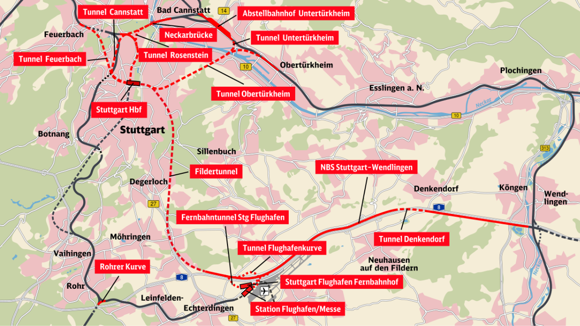
Stuttgart 21, or S21, in short, is a mega-scale undertaking by the largest national railway company in Germany, the Deutsche Bahn AG (DB), the state Baden-Württemberg, the German government, and the municipality of Stuttgart (Nagel and Satoh, 2019, pp. 1684). S21, being arguably the first project of this scope Stuttgart has ever witnessed, aims to convert the historical Hauptbahnhof station from a terminus, in which all trains had to reverse to depart, to an underground transit station adjusted to the technological demands of contemporary high-speed rail. This transformation is being achieved by rotating the platforms of the existing station by ninety degrees (Pepchinski, 2021) and constructing 57 kilometres of new tracks, half of which will be in underground tunnels (See Figure 1). As part of the recently excavated network of eight tunnels beneath Stuttgart’s city centre, which completed the boring process very recently in September this year (DB, 2023), this infrastructure will constitute a critical segment of ‘the European Magistrale’ linking key hubs of financial activity, including Paris, Munich, and Vienna (Varley, 2015, pp. 1).  

For decades, Stuttgart had been a bottleneck on the railway map of Germany due to the challenge associated with its physical geography; since it is situated in the narrow Neckar River valley, the current main train station design strived to maximise the on-ground transit capacity, considering these disadvantageous circumstances. That is why the initial re-development plans did not aim to interfere in the densely-populated inner city of Stuttgart and the busy central station; instead, they revolved around building a new through station in Rosenstein, located in the distant municipality’s surrounding area (Novy and Peters, 2012, pp. 130). Nonetheless, this less invasive proposal was not convincing enough for the local political elite at the time. For them, it was of crucial importance that the newly constructed continental route does not bypass the heart of the capital of Baden-Württemberg (Varley, 2015, pp. 2). Moreover, a project in which all rail services in the city would be moved below the surface of the earth has given them yet a further alluring possibility of boring an additional connection to the city’s airport and the recently built exhibition and trade centre in its close proximity (Novy and Peters, 2012, pp. 130).  

As a vital part of this venture, the DB is anticipated to revitalise extensive areas of soon-to-be unexploited railway land above ground, focusing on urban and economic development (Novy and Peters, 2012, pp. 130). Being acquainted with these extensive re-development plans, a question arises concerning who is intended to be the primary beneficiary of this investment. In the subsequent part of this report, I will analyse some of the issues associated with this mega project, which indicate that it is almost certainly not the local community but rather the DB itself. Consequently, S21 has been heavily criticised for a wide array of factors since its inception in the 1990s (Novy and Peters, 2012). From a sustainability perspective, these include, among many, exacerbating local environmental injustice and a lack of consideration for the urban history and its identity.  

Even though the first stage of S21 is due to be completed in the upcoming two years, the potential threat for the local communities associated with it is far from over. The construction costs exceeded 9 billion Euro in 2022 (Clinnick, 2022), whereas the initial approximations from 1995 stated that the venture required merely a quarter of the actual funds spent (Varley, 2015, pp. 1). Despite these excessive expenditures, the local policymakers do not appear to be discouraged. According to the recent review commissioned by the Baden-Württemberg’s government, there are ongoing discussions regarding supplementary expansions of S21, such as an additional terminus adjacent to the current station’s site and further tunnels (Fender, 2023). Hence, it is of uttermost importance that the inhabitants of Stuttgart’s centre brace themselves for plausible future developments and ensure that they possess more procedural justice, as defined by Pearsall and Pierce (2010), in public planning than at the outset of S21. 


The Community – Who is affected by S21? 

Being a project of an enormous scale, Stuttgart 21 has affected a broad spectrum of social groups, including commuters, owners of small-scale businesses, as well as the local homeless population, for which the now inaccessible surroundings of the train station provided a safe shelter. This last social group deserves particular attention, as the local authorities are accused of reaching for cruel and unusual measures. For example, playing loud classical music in areas not covered by the re-development, to drive the remaining homeless people out of the station area (El Ouassil, 2022). So, given the complexity of the problem, the most sensible option was to analyse the Stuttgart Mitte community collectively. Thus, this briefing’s target audience is 24 thousand inhabitants of the central district (stuttgart.de, n.d.) who suffered from a mega-scale project being built within the confines of their quarter. Furthermore, one remarkable aspect of Stuttgart Mitte is its distinct diversity: according to the city council’s statistics, as much as 48.7% of inhabitants of this district come from a migratory background (stuttgart.de, n.d.). This characteristic will play an important role in the recommendations section below.  

The Challenge 

Environmental Injustice  

In this section, I will elaborate on how this far-reaching project serves as a glaring demonstration of environmental injustice. The initial example of this is depriving the inhabitants of Stuttgart Mitte of high-quality urban green spaces. Stuttgart 21 has been widely criticised for its ecological ramifications in the city centre. To create new infrastructure, around 300 trees, many older than a century, have been felled in the historic castle grounds park complex, the Schlossgarten. located behind the current terminus (Novy and Peters, 2012, pp. 134). Moreover, as much as one-fifth of all trees relocated within the area as a part of this venture have not survived the sudden change in environment (Bock, 2019). This poses a serious environmental threat to the residents of the addressed district, as Stuttgart’s interior is especially prone to the urban heat island effect due to its disadvantageous topological location in the Neckar basin, between steep hill slopes.  (Climate-ADAPT, n.d.). Scientific data indicates that the number of days with high heat loads (more than 32 degrees Celsius) could double by the middle of the century compared to 1971-2000, and the Mitte community will be affected the most (Schlegel and Koßmann, 2017, pp. 6-7). However, it needs to be recognised that the project visualisations display new green urban space above the underground station. Nevertheless, even if the trees are, indeed, planted there, it will not be a valid compensation for the damages inflicted in the Schlossgarten. The history of this sizeable royal park dates six centuries back, and it is deeply embedded in the local identity. Therefore, a new green area built above the concrete layers of the station and its tunnels underneath incontestably cannot match its significance in both environmental and cultural realms.  

Furthermore, the project might have a harmful impact on the city’s groundwater resources. Stuttgart is the second city in Europe, following Budapest, in terms of the abundance of its mineral water springs (Vasin et al., 2015, pp. 705). The construction of the new transit station and tunnelling works might cause damage to the underground layers storing these water deposits, leading to leaks and subsequent drying up of this resource, which is unique for a European municipality (Hsieh, 2012, pp. 36). It is necessary to add that the groundwater available for the Mitte community is already endangered as things stand, as Stuttgart is one of Germany’s most heavily industrialised cities. Being home to enormous industrial magnates such as Porsche, Mercedes-Benz, or Bosch, the city and its local groundwaters have already been contaminated with volatile chlorinated hydrocarbons in the past (Vasin, et al., 2015, pp. 705). The S21 scheme can only exacerbate the current situation. For the Mitte district inhabitants, further jeopardy to the local mineral water reservoirs could mean they would be deprived of their benefits, commonly used for spa and medical purposes. Moreover, the issues of high-quality urban green spaces and mineral water sources are intertwined because moving the tracks to an underground level will effectively lower the local “table of groundwater”, which, subsequently, can cause additional damage to the Schlossgarten in the years to come (Hsieh, 2012, pp. 37). 

Disregard for the Mitte District’s identity  

One of the most controversial aspects of the S21 for the Mitte inhabitants was the partial demolition of the historic train station building. The old building’s north and the Schlossgarten wings, widely considered an architectural gem, have been destroyed for the re-development’s sake. The station structure designed by renowned architect Paul Bonatz was considered one of the city’s most recognisable landmarks in general and an icon of the inter-war period modernist design (Novy and Peters, 2012, pp. 136). The destruction has sparked massive outrage and civic distrust, leading to the forming of a human chain by thirty thousand locals around the demolition site in a desperate attempt to preserve their heritage (Gualini, 2015, pp. 72). Considering the cultural value of the knocked-down parts of the station, it is not surprising that this ordeal has been dubbed “a callous disregard for architectural history” by the international press (Ouroussoff, 2009). According to the critical urban theory, a city is made sustainable by the factors which its own residents believe to be that way. Yet, the urban has its own distinct history, and the policy-makers behind S21 did not take its importance into consideration. Since there are already ongoing talks of possible expansions to the controversial investment in the city centre, it is crucial to acknowledge the significance of the tangible historical heritage for the local community members in the further phases.  

 Community Recommendations 

Based on my research, I was able to highlight several recommendations that the community of the Stuttgart Mitte district could undertake to counteract the future challenges associated with S21 and its impact on sustainability and local culture. Being a foreign academic, someone describing the issue from outside, the following recommendations should be seen as ways to provide supplementary context to the community’s ongoing efforts and identify potential directions for future action. These include social media engagement, environmental education, as well as protest and publicity. 

Social Media Engagement 

The initial recommendation would be to encourage the Stuttgart Mitte community members to continue their high activity on social media. The described overambitious venture in the state capital of Baden-Württemberg lacked authentic and open-ended discussion with all local stakeholders. The local government insisted on pushing through its agenda throughout the mediation, rather than listening to the voices of the biggest citizen protests Germany had seen since its reunification (Varley, 2015, pp. 1). Therefore, thousands of Mitte residents resorted to social media to express their justified discontent and scepticism. Thus, S21 can be considered an actual turning point in social media-driven activism in recent years, as it allowed the grassroots movements to gain momentum and following, even if they were not included in participatory democracy processes at the start. Twitter, in particular, has always been an important outlet for individuals and groups looking to share their opinions on the contested project. Amidst rising Stuttgart’s 21 growing disapproval, the number of primarily unfavourable tweets containing the hashtag #S21 exceeded 165.000 (Jungherr and Jürgens, 2014, pp. 80). Therefore, the role of social media platforms such as X (formerly Twitter) cannot be underestimated. Considering the likely subsequent stages of S21, it is in the Mitte community’s interest to preserve their already established online communication space, which can assist them in the synchronisation, organisation, and documentation of collective action, including environmental issue campaigns or strikes (Jungherr and Jürgens, 2014, pp. 74). Moreover, considering the Mitte community’s structure, it is essential to ensure that more content and information relevant to the topic are shared in languages other than German. Because almost half of its members have a migratory background, providing supplementary information or translations to other languages is highly recommended, with them as the primary audience. Thus far, the vast preponderance of the discourse, especially the regional news articles concerning S21, is offered solely in German, which means that a substantial share of people affected by the DB investment are excluded from the ongoing conversation. Finally, platforms like X, Instagram and Facebook allow specialists and grassroots organisations in the fields of ecology or architecture to tag and address local policymakers, thereby safeguarding the community’s procedural justice through urban inclusion. 

Grassroots-led Environmental Education 

Secondly, suitable ecological education is another critical step in protecting the environmental justice of the inhabitants of the Stuttgart Mitte community. Environmental matters are already a part of the school curriculum, and the local University of Stuttgart organises events such as the ‘Sustainability Weeks’, which aim to raise awareness regarding the implications of lifestyle on the environment (University of Stuttgart, 2021). However, environmental education in the scrutinised district should transcend classrooms and university lecture hall perimeters to become more inclusive and engaging. Another issue is that the currently available education is not local enough. Due to Stuttgart’s topological specificity, as described above, the local communities might face far more severe environmental risks than inhabitants of other cities within South-Western Germany. Nonetheless, a significant share of the Mitte district residents is presumably not cognisant of the consequences of global warming, the urban heat island effect on their close surroundings. It is also plausible that they do not fully comprehend the meaning of the municipal assets in the context of climate change, including Stuttgart’s green areas or distinctive abundance of mineral water.  Furthermore, since the public educational institutions are administered by the Baden-Württemberg state government, which is a direct shareholder in the Stuttgart 21 investment, it is not probable that, within these entities, there will ever be any room for debate about the shortcomings or repercussions of the disputed project. Consequently, Stuttgart Mitte should prioritise community-driven initiatives, wherein residents initiate grassroots approaches that are unrestricted, critical, and concrete in enacting meaningful change. It is imperative to inform the uninvolved members of the Mitte community about the impacts that S21 has already instigated and how they can be exacerbated in the foreseeable future. These grassroots-led campaigns ought to solicit awareness regarding the repercussions of the partial loss of high-quality urban green spaces and the effect on precious municipal groundwater resources. This can be achieved through small-scale volunteer initiatives stationed in the city centre, especially in the areas close to the new station, such as the Schlossgarten Park. These public events should offer flyers with relevant information, provided in several languages, up-to-date statistics about S21, and the city’s overall estimations in the following decades concerning climate change. Lastly, this solution should be interconnected with the previous recommendation, viz., the digital campaign, so that it can reach a wider target group within the Mitte district. Therefore, I suggest that the on-site volunteers display slogans, website names, QR codes, and hashtags so that they can make their cause known to the community members who didn’t have their prior stance on the issue. By doing so, they can provide them with practical and convincing supplementary information they would not be likely to obtain from other media sources.  

Protests and Publicity 

The final recommendation of this briefing focuses on protests and publicity. This approach should only be viewed as a last resort in case the local authorities decide to carry out the extension to S21 as aggressively as back in 2010. Then, the images of peaceful local demonstrators being shot at with water cannons by the police caught countrywide attention and, as a result, led to a mediation process (Nagel and Satoh, 2019, pp. 1684). Therefore, the bolstering of publicity through protests enhanced the procedural justice of the Mitte community, as now they were, at least partially, included in the decision-making. What is more, protest as a means of resistance can be especially effective in Stuttgart when it concerns environmental protection. The reason is relatively straightforward: the Green Party is presently the most potent political force in the Stuttgart Municipal Council (stuttgart.de, n.d.). Therefore, the Mitte community should hold the authorities accountable if their actions about S21 do not match their political pledges and promises. Thus, in this case, protest can be used as a tool for ensuring the existence of participatory democracy. However, it is encouraged to match the form of these demonstrations to the profile of inhabitants who took part in the previous public events. The local media observed that the anti-S21 activists diverged from the typical protest demographics, consisting mainly of students, socialist scholars, and retired experts (Varley, 2015, pp. 12). If the protesting part of the community is “certainly not radical” (Varley, 2015, pp. 12), then future demonstrations should meet their needs. Hence, it is important not to follow a radical environmentalism path like organisations such as Extinction Rebellion or Just Stop Oil because action involving vandalism or other unorthodox measures may effectively discourage the target group within the Mitte district. Consequently, future protest action should remain peaceful and provide information to interested individuals, thus displaying a refined and knowledgeable image to the public. The initiative will garner increased public respect and engagement by upholding this reputation.  

Conclusion 

The Stuttgart Mitte community continues its fight for its ‘right to the city’, which is the foundation of the critical urban theory. Thus far, the overambitious infrastructural project in their neighbourhood has negatively affected their environmental and procedural justice. They have been deprived of a significant portion of their most beloved high-quality green space area. They have also lost an architectural marvel, a unique building which coexisted with them for almost a century. Throughout this time, it managed to become an integral part of the local identity. Now, facing a threat of extra stages of Stuttgart 21 in the foreseeable future, actions must be enacted as soon as the local policy-makers authorise them. The recommendations outlined in this briefing could help the residents of Stuttgart’s centre reinforce their position in public participation before any additional construction commences. They could feasibly spread awareness concerning the project and its consequences through social media engagement and grassroots-led environmental education. I firmly believe that these two suggestions, alone, will be able to bring about a significant difference in terms of the strength of the community movement. Nevertheless, were this to turn out to be insufficient, and the local authorities continue with undemocratic, top-down approaches analogously to the events of 2010. In that case, the Mitte community should consider the means of protest. Yet, they need to be cautious while employing it to not deter potential supporters by being overly radical. In the end, my recommendations only serve as a guiding framework and attaining realistic and feasible change depends on how the community members in question approach the issue themselves. 

Reference List  

Bock, J. (2019) ‘Umpflanzungen für Bahnhofsbaustelle Jeder fünfte Baum ist inzwischen tot’, Stuttgarter Nachrichten, 3 July [Online]. Available at https://www.stuttgarter-nachrichten.de/inhalt.umpflanzungen-fuer-bahnhofsbaustelle-jeder-fuenfte-baum-ist-inzwischen-tot.2e0b1645-ec06-449e-bfb9-6e2d405c3851.html (Accessed 8 October 2023).  

Climate-ADAPT (n.d.) ‘Stuttgart: combating the heat island effect and poor air quality with ventilation corridors and green-blue infrastructure’ [Online]. Available at https://climate-adapt.eea.europa.eu/en/metadata/case-studies/stuttgart-combating-the-heat-island-effect-and-poor-air-quality-with-green-ventilation-corridors/#challenges_anchor (Accessed 16 October 2023).  

Clinnick, R. (2022) ‘Stuttgart 21 project cost increases by €950m’, International Railway Journal, 24 March [Online]. Available at https://www.railjournal.com/infrastructure/stuttgart-21-project-cost-increases-by-e950m/ (Accessed 13 October 2023).  

DB Bahnprojekt Stuttgart-Ulm (n.d.) ‘Überblick’ [Online]. Available at https://www.bahnprojekt-stuttgart-ulm.de/projekt/ueberblick/stuttgart-21/ (Accessed 20 September 2023).  

Deutsche Bahn (2023) ‘Stuttgart 21: Alle Tunnel fertig gegraben’, Newsroom, 14 September [Online]. Available at https://www.deutschebahn.com/de/presse/pressestart_zentrales_uebersicht/Stuttgart-21-Alle-Tunnel-fertig-gegraben-11342950 (Accessed 21 September 2023).  

El Ouassil, S. (2022) ‘Obdachlosenfeindlichkeit in Deutschland Einfach kurz mal sein dürfen’ Spiegel Kultur, 29 September [Online]. Available at https://www.spiegel.de/kultur/obdachlosigkeit-in-deutschland-einfach-kurz-mal-sein-duerfen-kolumne-a-16f233bb-047e-42ad-bf4f-2d233858e457 (Accessed 14 October 2023).  

Fender, K. (2023) ‘Significant additional infrastructure needed to complement Stuttgart 21 project’, International Railway Journal, 21 March [Online]. Available at https://www.railjournal.com/infrastructure/significant-additional-infrastructure-needed-to-complement-stuttgart-21-project/ (Accessed 14 October 2023).  

Gualini, E. (2015) ‘Cycles of contention and the planning process: agnostic pluralism and social mobilisation against Stuttgart 21’ in Gualini, E., Mourato, J.M., Allegra, M. (eds) Conflict in the City: Contested Urban Spaces and Local Democracy, Berlin, JOVIS, pp. 60-77 [Online]. Available at https://www.researchgate.net/publication/287642509_Conflict_in_the_City_Contested_Urban_Spaces_and_Local_Democracy (Accessed 28 September 2023).  

Hsieh, C. (2012) ‘The Landscape of Gap Built Upon Environmental Subjects: A Case Study of Stuttgart 21, Germany’, Lund University Libraries, pp. 1-37 [Online]. Available at https://lup.lub.lu.se/student-papers/search/publication/2796091 (Accessed 18 October 2023).  

Jungherr, A. and Jürgens, P. (2013) ‘Through a Glass, Darkly: Tactical Support and Symbolic Association in Twitter Messages Commenting on Stuttgart 21’, Social Science Computer Review, vol. 32, no. 1, pp. 74-81 [Online]. DOI: 10.1177/0894439313500 (Accessed 18 October 2023).  

Nagel, M. and Satoh K. (2018) ‘Protesting iconic megaprojects. A discourse network analysis of the evolution of the conflict over Stuttgart 21’, Urban Studies, vol. 56, no. 8, pp. 1681–1700 [Online]. DOI: 10.1177/0042098018775903 (Accessed 25 September 2023).  

Novy, J. and Peters, D. (2012) ‘Railway Station Mega-Projects as Public Controversies: The Case of Stuttgart 21’, Built Environment, vol. 38, no. 1, pp. 128-145 [Online]. Available at https://www.jstor.org/stable/23289705 (Accessed 28 September 2023).  

Ouroussoff, N. (2009) ‘Last Call for an Elegant Rail Station’, The New York Times, 2 October [Online]. Available at https://www.nytimes.com/2009/10/03/arts/design/03railway.html (Accessed 17 October 2023).  

Pearsall, H. and Pierce, J. (2010) ‘Urban sustainability and environmental justice: evaluating the linkages in public planning/policy discourse’, The International Journal of Justice and Sustainability, vol. 15, no. 6, pp. 569–580 [Online]. DOI: 10.1080/13549839.2010.487528 (Accessed 15 September 2023).  

Pepchinski, M. (2021) ‘Main Station Stuttgart by Ingenhoven Architects’, Architectural Record, 1 August [Online]. Available at https://www.architecturalrecord.com/articles/15246-main-station-stuttgart-by-ingenhoven-architects (Accessed 26 September 2023).  

Schlegel, I. and Koßmann, M. (2017), ‘Stadtklimatische Untersuchungen der sommerlichen Wärmebelastung in Stuttgart als Grundlage zur Anpassung an den Klimawandel’, Deutscher Wetterdienst Abteilung Klima- und Umweltberatung Freiburg, pp. 6-7 [Online]. Available at https://www.stadtklima-stuttgart.de/index.php?klima_kliks_stadtklimatische_untersuchungen (Accessed 10 October 2023).  

Stuttgart.de (n.d.) ‘Gemeinderat Bündnis 90/Die Grünen’ [Online]. Available at https://www.stuttgart.de/rathaus/gemeinderat/mitglieder-des-gemeinderats/buendnis-90-die-gruenen.php (Accessed 19 October 2023). 

Stuttgart.de (n.d.) ‘Stadtbezirke Stuttgart‐Mitte’ [Online]. Available at https://www.stuttgart.de/rathaus/stadtbezirke/mitte/ (Accessed 12 October 2023).  

University of Stuttgart (2021) ‘University of Stuttgart at the Sustainability Weeks’, All News [Online]. Available at https://www.uni-stuttgart.de/en/university/news/all/sustainability-weeks/ (Accessed 19 October 2023).  

Varley, P. (2015) ‘Megaprojects & the Role of the Public: Germany’s Embattled ‘Stuttgart 21’ Rail Project’, Harvard Kennedy School, pp. 1-30 [Online]. Available at https://case.hks.harvard.edu/megaprojects-the-role-of-the-public-germany-s-embattled-stuttgart-21-rail-project/ (Accessed 11 October 2023).  

Vasin, S., Carle, A., Lang, U. and Kirchholtes, H.J. (2016) ‘A groundwater management plan for Stuttgart’, Science of The Total Environment, vol. 563-564, pp. 704-705 [Online]. DOI: 10.1016/j.scitotenv.2015.10.078 (Accessed 11 October 2023). 

Categories
Building Sustainable, Inclusive and Just Cities (Hons module)

New Orleans and The Lack of Adequate Infrastructure to be able to Withstand the Natural Environment: A Community-Led Grassroots Approach to Solutions 

Introduction

New Orleans is a place like no other, it is unique in every sense of the word, beautiful, soulful, hot and humid, overflowing with food, culture, pride, and one of the only places I believe can make anyone feel at home. But I am biased. Being born and raised in a place like New Orleans, Louisiana has given me a world view unlike most people I have ever met. On May 12th, 2021, at approximately 2am, a tornado tore the roof off my house, letting the storm outside in, while my entire family was home. But, despite this, despite being two years old when Hurricanes Katrina and Rita ravaged the city, despite the countless other hurricanes, tropical storms and disasters that defined my upbringing, I still love this city like no other. I was raised with the awareness of instability of place and the sense of looming threat that follows any strong breeze, hard rain or darkened sky, I was taught from a young age how Louisiana’s coast was slowly being washed away. I have lived and witnessed houses broken by wind and water, and people rebuilding them with passion and determination for this place called home. I know the people of New Orleans because I am one. Yet, I come from a part of the city that gets disaster relief first, I come from a household that can rebuild when disaster strikes and can afford to send me to university across an ocean. I am immensely grateful for my privileged experience of New Orleans and seek to give back to the city that made me who I am. I can never know the experience of another, but I live the experiences we share as a community and seek to understand the disproportionate ways others are affected, the ways in which we as a community have the power to change that. “The right to the city is not merely a right of access to what already exists, but a right to change it after our heart’s desire” (Harvey, 2003, p. 939). I believe as Harvey argues, we make the city and the city makes us, therefore the right to the city not only involves the right to change the physical makeup to more equitably suit its citizens, but it is the intrinsic right to “make the city different, to shape it more in accord with our heart’s desire, and to re-make ourselves thereby in a different image” (2003, p. 941). 

Hurricanes, Tropical Cyclones and the Historical Background of Southeast Louisiana 

According to data from the National Oceanic and Atmospheric Administration (NOAA) from the past 25 years, “the annual probability that New Orleans will experience a tropical cyclone is 92%. Due to its proximity to the Gulf Coast, in conjunction with ongoing coastal land loss and the likely impacts of climate change, New Orleans is especially vulnerable to tropical cyclones” (Ready NOLA, 2023). Broadly the Gulf Coast, and in this context, Southeast Louisiana are some of the most vulnerable regions affected by hurricanes, tropical storms and tropical cyclones (storm strength being the differentiating factor in classification). “Tropical cyclone winds can cause major structural damage to private homes, businesses, and the critical facilities of the signatories through water intrusion or structural failure” (Ready NOLA, 2023). The damage caused by storms of that magnitude is devastating and increasingly common in the region. In Leavitt and Kiefer’s post-Katrina analysis, they discuss how residents and political leaders alike would often describe their fear of “‘the big one,’ a storm that would come in from just the right direction and at the right strength to produce the wind and subsequent storm surge that would wipe out major portions of the region” (2006, p. 307). And they were right, on August 28, 2005, “Hurricane Katrina landed a devastating blow to the infrastructure of New Orleans and surrounding areas of the Gulf Coast. Katrina set in motion a series of failures in the region’s critical infrastructure that rendered significant areas uninhabitable for many months” (Leavitt and Kiefer, 2006, p. 307). There were many causes and reasons the devastation was so bad, many known to the local government predating the hurricane (Leavitt and Kiefer, 2006, p. 309), yet one of the most devastating results of the storm was the tearing of the social fabric of the city. “One of the first comprehensive surveys of the New Orleans evacuee population… determined that 39% of evacuees (some 50,000 households), mostly poor and Black, did not intend to return. If accurate, this will be the largest internal migration of Americans in a generation” (2006, p. 144), Campanella goes on to discuss the devastating ramifications this has, as so much of what makes a city is its communities. 

Orleans Parish 

The community which this briefing would like to address is that of Orleans Parish. Orleans Parish is New Orleans, but New Orleans is not only Orleans Parish. In other words, I have chosen this specific community because the scope of the Greater New Orleans Area (GNOA) is slightly too broad to address as one, in recent years neighboring parishes that are part of the GNOA such as Jefferson have become more self-determinant in rebuilding and improving infrastructure. Therefore, for this brief I will focus on Orleans Parish, and the neighborhoods within as a larger community that recognizes and celebrates the diversity it holds. Because, as Campanella states, “cities are more than the sum of their buildings. They are also thick concatenations of social and cultural matter, and it is often this that endows a place with its defining essence and identity” (2006, p. 142), and that the people of Orleans Parish do.  

Challenges of Inadequate Infrastructure to be able to Withstand the Natural Environment

As discussed in previous sections, New Orleans and the surrounding region are especially vulnerable to, and have been faced with, devastating tropical cyclones and hurricanes throughout their history. One of the primary challenges Orleans Parish faces is the insufficient infrastructure to be able to withstand and bounce back from the onslaught of natural disasters. Along with a lack of environmental justice that Pearsall and Pierce explain as, “characterised as a struggle against distributional inequity regarding environmental amenities…and efforts to increase the access of all populations to environmental decision-making” (Pearsall and Pierce, 2010, p. 570), with an emphasis on the last point of increased access to environmental decision-making. As a result of the lack of adequate infrastructure, New Orleans positions itself increasingly for normal disasters. Leavitt and Kiefer describe the concept of a normal disaster by explaining how it is almost inevitable or “normal” for a disaster to occur because of the reliance on high-risk technologies (2006, p. 307) and the multiple interactions of various complex and linear systems that are both tightly and loosely coupled (2006, p. 307). They argue, “that a normal disaster occurs when there is an event, disturbance, or problem that involves the complex interaction of interdependent infrastructures resulting in the unanticipated failure of multiple infrastructure systems” (Leavitt and Kiefer, 2006, p. 308). Which is exactly what happened in New Orleans in 2005 when the levees broke and the city became uninhabitable for months because of the failures of multiple critical infrastructures (Leavitt and Kiefer, 2006, p. 307). “The combination of normal disasters, such as Hurricane Katrina, and complex, interdependent, aging infrastructures does not bode well for the future” Leavitt and Kiefer urge, “substantial investment in infrastructure systems must once again become a national priority” (2006, p. 313) and that it must, if Orleans Parish is to survive. I contend normal disasters are still a major risk the city faces, as seen most recently in the past two months with the heightened attention (Edmonds, 2023) on the saltwater intrusion in the Mississippi River. 

The Saltwater Wedge 

Dubbed the Saltwater Wedge, in the past two months it dramatically garnered local, and even some national (Chavez, Edmonds, Rojanasakul, 2023) media attention sounding the alarms for yet another type of natural adversity the city faces. As a result of various factors including, “congressionally authorized enlargement of the Mississippi River’s deep-draft channel” (New Orleans District, U.S. Army Corps of Engineers, 2023) and “back-to-back years of drought throughout the Mississippi River valley” (Parker, Hazelwood and Juhasz, 2023). Saltwater has begun to move up the Mississippi River from the Gulf of Mexico. As the New Orleans District, U.S. Army Corps of Engineers’ website explains, “because salt water has a greater density than fresh water, it moves upstream in the form of a wedge” threatening not only the city’s water supply but over a million residents who get their water from the river (Chavez, 2023). Although this year it seems to have gained wider media coverage, “similar saltwater intrusions have happened about once every decade, including in 1988, 1999, 2012, and 2022” (Chavez, 2023). While initial predictions placed the wedge reaching the main intake pipe for Orleans Parish on October 28, updated predictions show that the wedge will not reach the city (New Orleans District, U.S. Army Corps of Engineers, 2023). Which is good news for Orleans Parish but the cataclysmic damage it would cause if it were to happen extends beyond the drinking water.  “Saltwater can accelerate the corrosion of pipes in water distribution systems[and] could corrode lead and galvanized steel pipes, possibly leaching heavy metals into drinking water, depending on how long the emergency lasts” (Chavez, 2023) which potential damages have been compared to the Flint, Michigan crisis. Another vulnerable system that would be heavily damaged, and likely shut down, if saltwater intruded upon it, is Entergy’s (the local power utility company) powerplants along the Mississippi leading to a string of affects within the cities critical infrastructures, a normal disaster. “It’s been a wake-up call for the region to upgrade water plants, expand pipeline networks, and make other improvements” (2023) Chavez says, echoed by Smith saying, “the threat this year has led New Orleans officials to call for a permanent solution to the problem, warning that it may occur more frequently given climate change’s impact on sea level rise and drought. That could involve a pipeline or desalination plant for the region, which would come at a high cost” (2023). A cost the people of Orleans Parish would pay. 

Brief Note of the Social Injustices Present in the City and the Vulnerabilities it Creates 

“Cities are extraordinarily durable” (Campanella, 2006, p. 141). This sentiment is like that of Harvey’s (2003, p. 939) explaining that cities are what remain, cities are what outlive us. Yet, what gives a city its character, soul and capacity to rebound (Campanella, 2006, p. 144) are its people. When discussing urban resilience in the context of post-Katrina New Orleans Campanella posits, “only with strong citizen involvement at the grassroots level will the rebuilding of New Orleans yield a robust and inclusive metropolis” (Campanella, 2006, p. 141). Which is true, but as previously mentioned, much of the city’s population was not able to immediately return after the devastation, and some not at all. Leading to the irony that, “the recovery of New Orleans as a real and robust city… rests heavily on the shoulders of those most burdened by the catastrophe” (Campanella, 2006, p. 144). Of which those most burdened are the black poor and other minorities within the city, which continue to suffer even after disasters as attempts to revive local economy begin. As Bledsoe and Wright argue, “civil society, therefore, is inherently antithetical to all manifestations of Black social life, yet requires Blackness for its political, economic, ontological, epistemological, and—as we aim to show—spatial coherence” (2018, p. 9). They highlight, “geographic interrogations of racial capitalism have analyzed the role of racist assumptions in implementing neoliberal reforms in the wake of a natural disaster” (Bledsoe and Wright, 2018, p. 11) which is especially poignant in a city as diverse as New Orleans. The capitalist agenda requires constant growth and expansion, so when I place is affect by natural disaster, which disproportionately affect minorities, and the whole mechanism halts and stutters, it becomes that much more imperative to restore it to a state of function as it was pre-disaster. That same pre-disaster state that perpetuates the social injustices that lead to the disproportionate effects on minorities in the first place. There is much more to this crucial topic, as Bledsoe and Wright discuss, so much so that an entire briefing should be written on this subject, but this briefing will refocus on the infrastructural dimension of the city that disproportionately effect the citizen of Orleans Parish. 

Recommendations

The primary way forward I recommend is the strong urge for an increased participatory approach to local decision-making, formalized lobbying for the local community to have say in planning infrastructure, other prevention methods and disaster relief. There are many ways to do this at various levels of influence from the bottom up. But for this to be a long-lasting, effective solution, that can be used as a model for other communities similarly affected by disasters, the first step is community education, which I argue needs to start from grassroots. A way this can be done is through grassroots organizations efforts as Irazábal and Neville describe, by empowering and emphasizing local community organizations people can take the power back into their hands. When this has been proven effective, it can then move into lobbying for a formal way of community input and regulatory power in municipal governments for an increased ability to have a say in what is prioritized and actioned by those who feel the direct affects. I would like to note, this is not intended to discount the efforts that have been made since Katrina to bolster the city’s infrastructure, which have been significant, it merely urges that the necessity for long-term change needs to come from the bottom by those most affected. 

Increasing and improving community education 

Though Sonne’s article pertains specifically to stormwater management, the ideas it argues can be applied more broadly, they state, “creating a supportive community educated about the benefits of such measures will alleviate some of the resistance that new utility fees often garner from the public. A public education program for New Orleans must begin now and must become increasingly aggressive to reach as much of the affected public as possible before any stormwater remediation fee can be successfully implemented” (2014, p. 347). This is a useful idea in the broader context of the city’s afflictions and the need to raise awareness of what they are and what can be done to prevent them. “When citizens have a clear understanding of what it takes for sustainable success in stormwater management, it is easier to embrace the unfamiliar, providing a lasting solution to their common problem” (Sonne, 2014, p. 348), and the same can be said about what it takes for improved infrastructure. The people of Orleans Parish have the capacity to understand the ways in which the infrastructure of the city needs to be revitalized yet require a means to gain that knowledge. Looking now at a historical example of an attempt at this, Leavitt and Kiefer offer us a glimpse of pre-Katrina New Orleans and “a series of regional ‘tabletop’ exercises [that] were conducted in the Greater New Orleans region for the past few years, each exercise examining the physical, geographic, and cyber-interdependencies of much of the region’s infrastructure” (2006, p. 309). Dubbed the ‘Purple Crescent exercises (Leavitt and Kiefer, 2006, p. 309), the ones that did take place were apparently quite useful for highlighting the interdependencies and vulnerabilities of the region’s infrastructure (2006, 309). Which I propose needs to happen once again, in a more sustained way that, hopefully, would not get cut short due to a cataclysmic failure in the exact infrastructural vulnerabilities being discussed (Leavitt and Kiefer, 2006, p. 310). A key opportunity for community oversight is highlighted by the response in the aftermath of Katrina, “although dependent on a system of regional infrastructure for protection, oversight of this infrastructure was fragmented among various municipal governments and agencies, many with long histories of mutual distrust and even animosity” (Leavitt and Kiefer, 2006, p. 311). If educational initiatives are as effective as they could be, local insight could aid municipal government invaluably, combining their lived knowledge and that of new programs about infrastructure. Leavitt and Kiefer urge, “the importance of identifying, understanding, and analyzing…infrastructure interdependencies…if we are to respond effectively to normal disasters. Whenever possible the goal must be to find ways to allow for decentralization of infrastructure systems to promote rapid recovery from disasters” (2006, p.312-3), this decentralization is the perfect opportunity for simultaneous community education, engagement and empowerment. 

Emphasis on grassroots organizations empowerment and efficacy 

Based on past examples of participatory democracy New Orleans has the base for it to work, there have been and still are many grassroot neighborhood-based organizations that work to better their community (Irazábal & Neville, 2007). Irazábal and Neville discuss the pre- and post-Katrina examples of grassroots planning for community development and reconstruction (2007). They highlight ideas of active citizenship, embracing the culture of New Orleans using that as a tool to transform it in the ways the city knows how (Irazábal and Neville, 2007 p. 135-136). As previously mentioned, there are two major aspects of planning, preventative and post disaster. There needs to be urgent focus on both prevention measures in the infrastructure of the city as well as detailed plans for when disaster strikes. There are limitations for rebuilding after the fact at the grassroots level, as seen during Katrina with the amount of people who returned (Campanella, 2006) not being enough to bolster the efforts of those who remained (Irazábal and Neville, 2007, p. 146). Hence why now it is imperative that people make plans for when disaster inevitably strikes and, seize the opportunity to work on renewing existing infrastructure that is known to be insufficient, whilst people are in the city. We must utilize existing neighbourhood groups, social clubs and other forms of local organisation in Orleans parish to come together and begin to learn and action what needs to be implemented infrastructurally and what is feasible on the grassroots level. Although the Unified New Orleans Plan is a date plan on post-Katrina reconstruction this imperative still stands, “institutionalize the organizational framework of the Unified New Orleans Plan by permanently incorporating community-based planning with coordinated citywide infrastructure planning. In doing so, planners can help formalize neighborhood-level decision making without bureaucratically bludgeoning the democratic instincts and empowered participation of residents” (Irazábal and Neville, 2007, p. 150). The second half of that statement is what the community education seeks to aid in avoiding, although there will always be to some degree the “bureaucratic bludgeoning” of empowered participation a more attuned citizen aware of the issues will be more likely to remain persistent. 

Acknowledgement of the Limitations and the Imperative to Continue 

To acknowledge the limitations of grassroots efforts as Irazábal and Neville lay out by stating, “the trajectory of recovery of New Orleans also illuminates the limits of grassroots planning in such catastrophic circumstances, and suggests that only larger and more comprehensive efforts, such as those possible for government(s), can create the conditions under which the grassroots efforts may organize meaningfully and effectively” (2007, p. 147). I urge the community of Orleans Parish, that to get to a place where municipal government implements formalized ways grassroots efforts can have a place in prevention and reconstruction, they need to be shown the efficacy and desire for this. Without existing grassroots efforts, that have proven results, there will never be movement towards a formalized participatory democracy more thoroughly than what exists currently. With an informed community that supports, and is involved in, grassroots planning efforts then the formalization limitations can be overcome. It is the people of New Orleans, the “stricken neighborhoods who constitute the lifeblood of the Big Easy, carrying in their traditions, cuisine, musical heritage, mannerisms, and habits of speech what made New Orleans unique” (Campanella, 2006, p. 144) and it is those people who can make coordinated grassroots efforts effective and long lasting. 

Conclusion

New Orleans is faced with many natural disasters and, as recent events have re-highlighted many other potential risks to our critical and non-critical infrastructure. The first step in finding a solution is community education, which needs to be done from the bottom up. There are then two primary opportunities to approach these challenges, preventative measures and post disaster/event response. Both these can be affected and improved by local community engagement and participation, as I hope to have demonstrated in this briefing. Although there are many hurdles to be overcome it is only through collective community action that real change is seen. We cannot simply wait for the change to happen, it needs to start from the bottom and be brought to the top for lasting change to be permanently implemented, so the people who are most affected get a valued and deserved voice in infrastructure that is meant to protect them. “Humanity is now considered to be not simply one of earth’s biological factors, but a geological actor too; an actor that shapes geophysical transformations on the earth’s stratigraphy the way only ‘natural’ forces used to do in earth’s previous long history” (Kaika, 2018, p. 1716). If humanity is that crucial of an actor, who also needs take responsibility, in the geophysical transformation of our planet, then there is no doubt that the people of Orleans Parish can reshape their city into a more equitable, infrastructurally sound, community where no one’s right to the city (Harvey 2003) is called into question.

References 

Bledsoe, A. & Wright, W. J. (2018) ‘The anti-Blackness of global capital’, Environment and Planning D: Society and Space, 37 (1), 8-26. 

Campanella, T. J. (2006) ‘Urban Resilience and the Recovery of New Orleans’, Journal of the American Planning Association, 72 (2), 141-146. 

Campbell, S. (2013) ‘Sustainable Development and Social Justice: Conflicting Urgencies and the Search for Common Ground in Urban and Regional Planning’, Michigan Journal of Sustainability, 1, 75-91. 

Chavez, R. (2023) Why the saltwater wedge climbing up the Mississippi River is a wake-up call to the region. Available at: https://www.pbs.org/newshour/nation/why-salt-water-is-threatening-drinking-water-in-new-orleans-and-what-officials-are-doing-about-it (Accessed: 26 October 2023). 

Edmonds, C. (2023) Saltwater in the Mississippi Threatens Water Supply in New Orleans. Available at: https://www.nytimes.com/2023/09/23/us/saltwater-mississippi-new-orleans.html (Accessed: 26 October 2023). 

Harvey, D. (2003) ‘The Right to the City’, International Journal of Urban and Regional Research, 27 (4), 939-941. 

Irazábal, C. & Neville, J. (2007) ‘Neighbourhoods in the Lead: Grassroots Planning for Social Transformation in Post-Katrina New Orleans?’, Planning, Practice & Research, 22 (2), 131-153. 

Kaika, M. (2018) ‘Between the frog and the eagle: claiming a ‘Scholarship of Presence’ for the Anthropocene’, European Planning Studies, 26 (9), 1714-1727. 

Leavitt, W. M. & Kiefer, J. J. (2006) ‘Infrastructure Interdependency and the Creation of a Normal Disaster The Case of Hurricane Katrina and the City of New Orleans’, Public Works Management & Policy, 10 (4), 306-314. 

New Orleans District, U.S. Army Corps of Engineers (2023) A Saltwater Wedge Affects the Mississippi. Available at: https://www.mvn.usace.army.mil/Missions/Engineering/Stage-and-Hydrologic-Data/SaltwaterWedge/ (Accessed: 26 October 2023). 

New Orleans District, U.S. Army Corps of Engineers (2023) An Overview of the Mississippi River’s Saltwater Wedge. Available at: https://www.mvn.usace.army.mil/Missions/Engineering/Stage-and-Hydrologic-Data/SaltwaterWedge/SaltwaterWedgeOverview/ (Accessed: 26 October 2023). 

NOLA Ready (2023) About Saltwater Intrusion. Available at: https://ready.nola.gov/incident/saltwater-intrusion/about-saltwater-intrusion/?utm_source=nola&utm_medium=banner (Accessed: 26 October 2023). 

NOLA Ready Tropical Cyclones. Available at: https://ready.nola.gov/hazard-mitigation/hazards/tropical-cyclones/#top (Accessed: 26 October 2023). 

Parker, H. & Juhasz, A. (2023) We answer your questions about the saltwater wedge in the Mississippi River. Available at: https://www.wwno.org/coastal-desk/2023-09-27/we-answer-your-questions-about-the-saltwater-wedge-in-the-mississippi-river#q-2 (Accessed: 26 October 2023). 

Parker, H., Hazelwood, G. & Juhasz, A. (2023) Saltwater wedge moving slower than projected; unlikely to reach New Orleans until late November. Available at: https://www.wwno.org/coastal-desk/2023-10-05/saltwater-wedge-moving-slower-than-projected-unlikely-to-reach-new-orleans-until-late-november (Accessed: 26 October 2023). 

Pearsall, H. & Pierce, J. (2010) ‘Urban sustainability and environmental justice: evaluating the linkages in public planning / policy discourse’, Local Environment, 15 (6), 569-580. 

Rojanasakul, M. (2023) When Will the Saltwater Wedge Reach New Orleans? We Mapped It. Available at: https://www.nytimes.com/interactive/2023/09/29/climate/new-orleans-saltwater-map.html?action=click (Accessed: 26 October 2023). 

Skilton, L. (2023) Hurricanes in Louisiana. Available at: https://64parishes.org/entry/hurricanes-in-louisiana (Accessed: 26 October 2023). 

Smith, M. (2023) The new saltwater forecast is out for the New Orleans area. Here’s what is shows. Available at: https://www.nola.com/news/environment/new-saltwater-forecast-means-good-news-for-new-orleans-area/article_2624ced4-6e90-11ee-8a93-0747faff9b9b.html (Accessed: 26 October 2023). 

Sonne, B. (2014) ‘Managing Stormwater by Sustainable Measures: Preventing Neighborhood Flooding and Green Infrastructure Implementation in New Orleans’, Tulane Environmental Law Journal, 27 (323), 323-350. 

Categories
Building Sustainable, Inclusive and Just Cities (Hons module)

Taking Control of the Energy Crisis – A community-owned solar panel system in Beirut, Lebanon as a way forward    

Introduction  

Beirut is home to diverse communities and has a rich and lively culture. The many summers I spent in Beirut as a child, gave me insights into the love the people have for the city, but also the daily struggles of Beirutis since the start of the 15-year civil war in 1975. More recently, Lebanon has been dealing with five crises simultaneously, which are heavily centred around governmental mismanagement (Moore, 2023). Three are Lebanon-specific crises: the influx of Syrian refugees into the country, the meltdown of the banking and economic system; and the aftermath of the August 2020 Beirut port explosion. Two are global crises from which Lebanon is not spared: the aftermath of the COVID pandemic and the continual effects of climate change. On the World Bank (2021) list of countries experiencing the most severe crises since the mid-1900s, Lebanon is in the top three. The lack of effective governance and severe economic crisis have resulted in an almost complete loss of government-supplied electricity in Beirut, forcing a whole alternative industry of privately owned generators and more recently solar panels. These crises combined, specifically, the lack of effective governance and severe economic crisis have resulted in an almost complete loss of electricity in the city. The extent to which communities in Beirut have been affected by the aforementioned crises cannot be encompassed in a single paper, however, my goal in this briefing is to provide a community-led alternative solution which moves away from the involvement of the government, a root cause of the current electricity crisis in Lebanon.   

The Community 

The Sabra neighbourhood, defined by the UN-Habitat (2019) as a ‘disadvantaged neighbourhood in Beirut’ is a diverse bubble of about 6,215 inhabitants. It is made up of about 50% Lebanese citizens and it also hosts Syrian and Palestinian refugees. Sabra acts as an extension of the Shatila refugee camp found in the neighbouring community (UN Habitat, 2019). The struggles faced by this community are deeply rooted in its horrifying historical context. In 1982, during the Lebanese civil war, the Shatila refugee camp and the neighbouring community of Sabra were attacked by a Christian militia group (the Phalange), who were aided by the Israeli army which was occupying Lebanon at the time (Al Jazeera, 2022). The Israeli army surrounded the district to allow the Phalange militia to enter and attack civilians for over 2 days. Around 3,500 lives were taken, and this massacre was deemed an “act of genocide” by the UN General Assembly; however, neither party was ever held accountable for the tragedy (Al Jazeera, 2022). To this day, the people of Sabra are still dealing with the effects of this massacre. Currently, most of the Sabra residents are in the low-income bracket and do not have access to adequate living conditions, most importantly a reliable source of energy.  

The Challenge

Environmental justice is heavily discussed in the literature tackling ‘sustainable cities’. According to Pearsall and Pierce (2010), environmental justice is a theoretical concept that focuses on (1) how environmental burdens are divided among groups of people, and (2) the rights of the citizens to take part in the environmental decision-making process. (1) is defined as distributional justice and (2) as procedural justice. Since Sabra’s residents face energy poverty, they are not insulated from the effects of climate change like those with readily accessible electricity. This is a typical example of distributional injustice. Dagher et al., 2023 show that there is a correlation between lower energy poverty and households with higher levels of education. Thus, this community, which is comprised primarily of low-income residents and refugees, have disproportionality less access to energy. Furthermore, only 10% of the residents have fully functional government-supplied electricity grids (UN-Habitat, 2019). After the 2020 port explosion, the technical problems with the electrical grid increased because its infrastructure was heavily damaged throughout the city (Tarnini et al., 2023). So, with an average household receiving only two hours of electricity a day, private diesel generator (DG) systems have become the new electricity market in Lebanon (Simet et al., 2023). The energy market transition was guided by higher-income households with access to DG systems. This demonstrates procedural injustice as the Sabra community did not have control over this DG energy transition (Simet et al., 2023).  

This energy crisis affecting all of Lebanon has roots in Moore’s (2023) ‘five crises’ discussed above. One of the most significant contributors to the energy crisis is the economic let-down that began in 2019, when the Lebanese Lira was hit by record inflation of 8,580%, a jump from 1 USD = LBP 1,515 to 130,000 in 2023 (Tarini et al., 2023). In addition, Lebanon has a low Human Capital Index because citizens have comparatively poor basic public services. This is further compounded by the increasingly apparent climate change crisis, especially in Beirut as it is a coastal low-lying city (Moore, 2023). The term ‘crisis’ acknowledges the different challenges faced by this community; however, Sirri (2021) indicates that this term crisis is typically associated with a short-term or recent problem. The corruption and mismanagement of the post-war Lebanese government is directly correlated with the collapse of public industries like the energy sector (Simet et al., 2023). Hence, the energy problem is complex and is a result of a long history of political turmoil that has led to deeply rooted social, environmental, and economic, inequalities. Therefore, any solution to the energy crisis in the Sabra neighbourhood must rely on multi-stakeholder involvement that does not involve the Lebanese government. This favours solutions like the long-term community-led energy strategy suggested below.  

Community Response So Far 

Most communities in Beirut have relied on DGs, which was a practical solution in the past when the government subsidised diesel. However, this led to smuggling and illegal activities, which then led to diesel shortage, and consequently, the elimination of diesel subsidies (Dagher et al., 2023). DGs heavily contribute to climate change, but more importantly, they have become increasingly expensive because of the subsidy removal. For households, the market value of DG systems is at 2 billion USD (Adbdelnour et al., 2023). For low-income households, this option puts an unsustainable financial burden on families attempting to gain access to basic public services. On a more positive note, Zahle, the third largest city in Lebanon, has implemented a hydropower solution, which resulted in a decrease in energy poverty and less reliance on DGs (Dagher et al., 2023). Considering that so many of the country’s problems are rooted in the instability and corruption of the government, it is not always possible for communities like Sabra to depend on the municipality for real change, as seen in Zahle. Thus, several higher-income households have opted to install their own photovoltaic (PV) systems. How can we make this more accessible to low-income communities like Sabra?  

Suggestion Moving Forward

Overview 

Lebanon receives about 300 days of sun per year and experiences 7 months of a dry season (Moore, 2023). As renewable energies become increasingly affordable, there has been a steep increase in solar panel usage (81%) in Lebanon from 2010-2020 (Adbdelnour et al., 2023). Diesel energy is about 45 cents per kWh versus solar energy at 9-10 cents per kWh. Hence, the PV systems are becoming more appealing to Lebanese communities. Other renewable energies like hydropower and wind energy could be successful but would likely require involvement from the municipalities and government. In the past, the idea of solar farms in Lebanon has generated excitement but has ultimately been unsuccessful (Moore, 2023). Solar panels are an ideal renewable energy source for Sabra because 85% of its buildings are mixed-use and/or residential making them suitable for PV system placement and community sharing (UN-Habitat, 2019). Thus, this community briefing suggests the implementation of a community-owned and shared de-centralised solar (PV) system.  

Most consumers in Lebanon with the financial means buy private PV grids that are used to supplement the few hours of government-provided energy per day. However, Adbdelnour et al. (2023) explain that these two systems are used in conjunction because the few solar panels purchased by each household do not supply enough reliable energy for the household’s daily requirements. Even if they can afford it, there are space limitations on the roofs of a congested city like Beirut to provide each apartment with its full need of PV panels. To resolve this limitation and as suggested by several other scholars in the literature, Adbdelnour et al. (2023) propose a Peer-to-Peer (P2P) energy trading system. Essentially, it is a bottom-up (community-led) energy exchange platform that makes the energy consumer a ‘prosumer’ and allows them to sell and buy energy based on their household needs (Trivedi et al., 2022). Therefore, excess energy will not be wasted and instead, it will beshared around the community. In this suggestion, Adbdelnour et al. (2023) propose that the initial significant investment to purchase solar panels will come from community members. Unfortunately, in the case of the Sabra, this is not an achievable option, requiring alternative funding solutions.  

A PV system for the size of the Sabra community can be defined as a micro-grid system due to its small size. The development of microgrids is becoming increasingly popular in Lebanon and all over the world as it localises and decentralises renewable energy sources. Two somewhat well-known microgrid set-ups in Lebanon have inspired the Sabra initiative, the Baaloul project and the Menjez project. Baaloul, a town in the Bekaa Valley of Lebanon received funding from USAID, and support from CARITAS (a catholic-relief organisation) to develop community-owned PV micro-grids (Social Impact Inc., 2020). This initiative was extremely successful and reduced household and municipal energy bills by 25% (National News Agency, 2018). However, Chaplain (2022) notes that although this was community-led in partnership with third-party organizations, the Syrian refugee population was not included in decision-making and consequently did not gain much from the initiative. This once again depicts procedural injustice as the refugee community now only receive energy when it is in excess, which is rare. The Menjez project, on the other hand, was not as successful. This project also received funding from USAID and is supported by the René Moawad Foundation (RMF). The RMF is a political relief organisation that unfortunately used this initiative to expand its political clout in the region. This initiative is owned by the local municipality, meaning that they take tariffs on the energy and the community does not receive any profits. To avoid such complications based on previous experiences in Lebanon, the suggested Sabra initiative will not involve the government or local municipalities and aims to find alternative approaches without involving any political actors.  

A Decentralised On-Grid System  

Based on the above discussion, a decentralised community-based microgrid (C-MG) solution is a viable solution to support the energy needs of the Sabra community. Trivedi et al. (2023) lays out various C-MG strategies based on the existing literature including centralised, distributed, and decentralised approaches. A decentralised structure is best suited for Sabra because it has comparatively higher levels of community engagement, a high possibility for scalability in the future, and is relatively less complex. Let us break this down further. The American University of Beirut (AUB) and SOAS University of London held a workshop in 2021, that analysed “models for tackling Lebanon’s electricity crisis”. They explained that the increased use of renewable energy in Lebanon has occurred out of necessity and has been particularly successful when the private or community sector is involved (either from an investment or managerial standpoint) (ACE, 2021). This urges the need for a decentralised approach. ACE (2021) agree with Trivedi et al. (2023) in that this system would make a consistent energy supply more accessible to different community members and would reduce the energy monopoly based on DGs. Gaining access to reliable energy sources for Sabra will positively impact daily life for its residents. Giving access to these basic human rights allows for stronger development of the community and an ‘urban citizen’ identity, thus giving ownership of the city to the people (Moore, pg. 170, 2023) (UCL, 2020).  

ACE (2021) do pose the challenge of the large initial investment for the PV systems. As discussed in more depth below, taking a loan could be a possible approach to alleviate the financial burden. However, this approach implies that the initial instalment of the solar panels in Sabra is used in combination with the existing DGs. The Beirut Arab University’s (BAU) transition to renewable energy inspired this mixed approach for the initial phase of the Sabra C-MG system (Tarnini et al., 2023). Before implementing any changes on the campus, BAU scholars used HOMER, a platform that runs simulations of various energy systems. They simulated off-grid solar, on-grid solar, and DG systems. Tarnini et al. (2023) found that the DG system was impractical from a financial standpoint in the long run and was environmentally unsafe. The off-grid system was the most sustainable and environmentally friendly; however, the high investment costs, lack of available land, and “system reliability” issues made it unsuitable for this institution. The on-grid PV system in combination with DG, when necessary (in winter months), had the best return on investment and allowed for the DG’s to be used less, also lowering their maintenance and operational costs. The on-grid PV system was successfully implemented at the BAU university campus. The strategy and implementation will be different in Sabra as this is a bottom-up approach compared to the institutionally driven project at BAU. However, this initiative provides concrete evidence that a C-MG strategy is a practical approach to reducing energy poverty at a localised level in Lebanon.  

Implementation 

Stakeholders 

This initiative would be a multi-stakeholder approach involving local and international actors. In both the Menjez and Baaloul projects, sustainable change was implemented with the involvement of various parties. The Sabra neighbourhood has worked with the UN before to improve the living conditions on El Jazzar Street in Sabra (United Nations, 2021). The organisers put community engagement at the forefront of the project, allowing women and men from various nationalities and ages to decide on infrastructural changes that would lead to a better quality of life. Although a small initiative, it gives an insight into the possibilities of collaborating with the Sabra community in achieving a sustainable and reliable energy system.  

Alongside an international organisation like the UN, it could be beneficial to include a solar NGO with a high level of expertise in setting up on-grid PV systems. Some possible NGOs that were investigated include but are not limited to SolarAid, Solar Village Project, and SELF (Solar Electric Light Fund). This is important to ensure that the goals of the Sabra community stay at the forefront of the stakeholders’ motivations, prioritizing environmental justice as a core value. These NGOs have not done work in the Levantine region in the past, but they could be incentivized to do so in the future. The choice of the specific NGO(s) will depend on the funding source as well.  

As BAU did with its academic scholars, it would be valuable to partner with a research group that can aid in running the technical aspects of this initiative (Tarnini et al., 2023). At BAU, the academics used the HOMER system to fully simulate the financial and environmental effects of different energy systems. This briefing advocates for a similar approach in Sabra. The Sabra community could partner with the Beirut Urban Lab, an urban studies research group, who would be well-suited for this project, considering they have previous experience in urban recovery projects and simulation mapping (Beirut Urban Lab, 2023)  

Funding 

Between the five crises Lebanon faces, it has one of the largest public debts in the world. From 1992-2017, $36 billion of this debt has come from the electricity sector (UCL, 2020). Poorer neighbourhoods like Sabra face significant energy poverty especially after the government ended its diesel subsidies (UCL, 2020). Thus, the initial hesitation to implement renewables has declined, and solar panels are becoming a necessity to achieve reliable energy. PV systems have a high initial capital, but they have a better return on investment in the long term compared to fossil fuels (Tarnini et al., 2023).  

Funding for PV panels in Sabra could come from various sources. The first source could be a grant from USAID like that of the Baaloul and Menjez projects. Another opportunity could be crowdfunding in combination with a loan that would be paid back over time from the trading (buying and selling) of energy. Lastly, several of the NGOs discussed above provide PV systems for disadvantaged areas at a significantly lower cost. Thus, a partnership with an NGO could be extremely appealing to this community. Regardless of how the funding source is secured, the community must have full ownership of the microgrid.  

Layout of the System 

The recommended structural design is a five ‘layer’ system, as outlined by Trivedi et al.’s (2022) thorough literature review of community-based microgrids. The five layers are: (1) physical, (2) information communication and transmission, (3) market and business, (4) regulation, and (5) control layer. The overarching goal of the structural design is to educate and collaborate with the community at each step. Discussions at the UCL (2020) energy workshop stressed the need for community awareness and engagement campaigns as a necessary factor, regardless of whether the municipalities were involved. For instance, the community in the Akkar region of Lebanon heavily resisted the construction of a wind farm because they assumed the turbines were unsafe and that they could fall off the motors and injure people (UCL, 2020). Once this issue was addressed, the community was eager to see the installations. Therefore, the social factor needs to be addressed for procedural and distributional environmental justice to be established in Sabra. Below is a brief description of each layer. 

Physical Layer 

The physical layer covers the actual equipment needed for the microgrids. Ideally, the PV systems will be purchased through grants and subsidies so that the low-income community of Sabra does not assume the financial burden while retaining community ownership.  

Market and business layer 

The market and business layer is separate from the implementation actors (such as NGOs, Beirut Urban Lab, and UN). Instead, the focus here is the Peer-to-Peer (P2P) energy trading system discussed above (Adbdelnour et al., 2023). This strategy is associated with a decentralised structure because the consumer can become the producer (making them a ‘prosumer’). Essentially, each building or household will have a smart meter and app system. This will then allow the prosumer to give/sell their excess energy to other households, ensuring that not only is energy not wasted, but also that households have a more reliable source of energy (Adbdelnour et al., 2023). Trivedi et al. (2022) support this suggestion and add that it leads to a micro-balanced market. 

Information, communication, and transmission layer 

Interoperability is key to understanding this layer. Interoperability is the ability of a computer or technical system to work in conjunction with other systems (Trivedi et al., 2022). The interoperability system plays an important role in ensuring that energy sharing between various households is possible. Thus, this briefing suggests the installation of a smart meter and app system that work together. The Brooklyn Micro Grid (BMG) (2019) is a clear example of a successful initiative. Essentially BMG is an energy marketplace managed by the prosumers at a local level (BMG, 2019). When energy is created in excess by a certain household, it is detected by a smart meter and can be sold to another household on the app through the smart meter (UCL, 2020, pg. 18).  

Regulation layer 

To ensure that such systems become a long-term solution and run smoothly, Trivedi et al. (2022) suggest that a policy document be put into place. This would include the rules and regulations for the system. Ideally, this is agreed upon by the community members who will benefit the most from this micro-grid solution. The Beirut Urban Lab would be the perfect collaborator on such a legal document because they have done similar work in the past (Al-Harithy & Yassine, 2023). 

Control layer  

The control layer ensures proper maintenance of the PV systems. Once again, this highlights the need for community and social awareness to run the system and deal with technical errors and long-term maintenance. The trading platform described above could also pay for the upkeep. Teaching the community these skills will also allow for independence in running the PV panels. However, if the initiative is operated by an NGO that provides the PV panels, it could also be involved in the control layer.  

Conclusion

The suggested solution aims to install a reliable, sustainable, community owned and managed energy solution for the Sabra community. This would provide hope and functionality to the Sabra community while simultaneously outlining several technical, organisational, and financial factors that need to be considered for implementation. It does not aim to suggest that this is a perfect solution for the Sabra community that has been faced with political corruption for years on end. It is however a plausible and implementable solution based on knowledge of the Lebanese situation and a review of the current literature and available opportunities building on successful examples in Lebanon. A possible limitation would be to ensure that the various stakeholders involved are able to collaborate smoothly as this would be integral to the success of this energy transition. The success of the proposed micro-grid solution will lead to environmental justice as argued by Boone and Fragkias (2013). Importantly though the success of the proposed community-owned micro-grid solution may have significant implications on energy equity in Lebanon: its success could have a domino effect with other communities wanting to emulate it.  

References 

ACE (2021) ‘Watch webinar: Models for tackling Lebanon’s electricity crisis’, ace, 4 February. Available at: https://ace.soas.ac.uk/webinar-models-for-tackling-lebanons-electricity-crisis/ (Accessed: 10 October 2023). 

Adbdelnour, V. et al. (2023) ‘Energy Management Model Suitable for the Lebanese Case’, in. 2023 6th International Conference on Renewable Energy for Developing Countries, REDEC 2023, pp. 157–162. Available at: https://doi.org/10.1109/REDEC58286.2023.10208196

Al Jazeera (2022) Sabra and Shatila massacre: What happened in Lebanon in 1982? Available at: https://www.aljazeera.com/news/2022/9/16/sabra-and-shatila-massacre-40-years-on-explainer (Accessed: 10 October 2023). 

Al-Harithy, H. and Yassine, B. (2023) Beirut Urban Lab – The Co-Production of a Shared Community Space in Al-Khodor, Karantina, Beirut Urban Lab. Available at: http://beiruturbanlab.com/en/Details/1945 (Accessed: 9 October 2023). 

Beirut Urban Lab (2023) Beirut Urban Lab – Three Years of Post-Blast Observations@BeirutUrbanLab. Available at: http://beiruturbanlab.com/en/Details/1926 (Accessed: 13 October 2023). 

BMG (2019) Brooklyn Microgrid | Community Powered EnergyBrooklyn Microgrid. Available at: https://www.brooklyn.energy (Accessed: 25 October 2023). 

Chaplain, A. (2022) ‘Strategies of Power and the Emergence of Hybrid Mini-Grids in Lebanon’. Available at: https://sciencespo.hal.science/hal-03608202/document

Dagher, L., Jamali, I. and Abi Younes, O. (2023) ‘Extreme energy poverty: The aftermath of Lebanon’s economic collapse’, Energy Policy, 183. Available at: https://doi.org/10.1016/j.enpol.2023.113783

Moore, H.L., Collins, H. and Makki, D. (2023) ‘Decentralised renewable energy: a pathway to prosperity for Lebanon?’, in H.L. Moore et al. (eds) Prosperity in the Twenty-First Century. UCL Press (Concepts, models and metrics), pp. 149–178. Available at: https://doi.org/10.2307/j.ctv33pb01p.14

National News Agency (2018) USAID and Baaloul Community celebrate the completion of a solar power generation project for Baaloul villageMTV Lebanon. Available at: https://www.mtv.com.lb/news/852654 (Accessed: 12 October 2023). 

Pearsall, H. and Pierce, J. (2010) ‘Urban sustainability and environmental justice: evaluating the linkages in public planning/policy discourse’, Local Environment, 15(6), pp. 569–580. Available at: https://doi.org/10.1080/13549839.2010.487528

Simet, L. et al. (2023) ‘“Cut Off From Life Itself”’, Human Rights Watch [Preprint]. Available at: https://www.hrw.org/report/2023/03/09/cut-life-itself/lebanons-failure-right-electricity (Accessed: 12 October 2023). 

Sirri, O. (2021) Beirut Urban Lab – Waiting for Urgency in Beirut@BeirutUrbanLab. Available at: http://beiruturbanlab.com/en/Details/781 (Accessed: 9 October 2023). 

Social Impact, Inc. (2020) Building Alliances for Local Advancement, Development, and Investment — Caritas Lebanon: Final Performance EvaluationResilienceLinks. Available at: https://www.resiliencelinks.org/resources/reports/building-alliances-local-advancement-development-and-investment-caritas-lebanon (Accessed: 12 October 2023). 

Tarnini, M. et al. (2023) Towards Energy Sustainability in University Campuses: A Case Study of Beirut Arab University. Available at: https://www.mdpi.com/2071-1050/15/9/7695 (Accessed: 10 October 2023). 

Trivedi, R. et al. (2022) Community-Based Microgrids: Literature Review and Pathways to Decarbonise the Local Electricity NetworkEnergies, 15(3), p. 918. Available at: https://doi.org/10.3390/en15030918

UCL (2020) Transitions to Renewable Energy and Sustainable Prosperity in LebanonUCL Institute for Global Prosperity. Available at: https://www.ucl.ac.uk/bartlett/igp/publications/2022/feb/transitions-renewable-energy-and-sustainable-prosperity-lebanon-0 (Accessed: 10 October 2023). 

UN-Habitat (2019) Story Map Series. Available at: https://un-habitat.maps.arcgis.com/apps/MapSeries/index.html?appid=0ed602c1e30a4b4c81957bbed75f894b (Accessed: 11 October 2023). 

United Nations (2021) Fostering hope in El Jazzar Street, Sabra, Beirut by improved living conditions | UN-Habitat. Available at: https://unhabitat.org/news/29-nov-2021/fostering-hope-in-el-jazzar-street-sabra-beirut-by-improved-living-conditions (Accessed: 3 October 2023). 

World Bank (2021) Lebanon Economic Monitor, Spring 2021: Lebanon Sinking (to the Top 3)World Bank. Available at: https://www.worldbank.org/en/country/lebanon/publication/lebanon-economic-monitor-spring-2021-lebanon-sinking-to-the-top-3 (Accessed: 25 October 2023). 

Categories
Building Sustainable, Inclusive and Just Cities (Hons module)

Opportunities for Revitalization: Exploring Minneapolis Brownfields 

Introduction  

As a resident of the Twin Cities Metropolitan Area (TCMA) and having grown up in a particularly disadvantaged neighbourhood in St Paul, I have seen the aesthetic effect of brownfields first hand. Although I have not experienced direct effects they can have on health and environmental indicators, I witnessed the conversion of brownfields in my own community and observed the effect they can have on community empowerment and coordination, as well as community members themselves.   

This paper outlines specific challenges associated with brownfields that are faced by multiple Minneapolis inner-city neighbourhoods, and discusses environmental, social, health, and economic implications of brownfield clean up and redevelopment. It will also propose several recommendations for the local community; suggesting ways in which neighbourhoods can be active participants and take initiative of redevelopment strategies. The scale of this challenge is unique in that the severity of its implications are inherently spatial, as the proximity of brownfields to low-income communities and communities of colour is a coincidence of specific development and settlement patterns.   

Historical Context  

The city of Minneapolis, Minnesota, situated within Hennepin County, is the larger of the two cities within the TCMA. Highly sought after because of its placement surrounding the Mississippi River, Minneapolis possessed access to the only major waterfall on the river, St Anthony Falls, making it an industrial focal point in Minnesota (MHS, 2023). During the early 1850s, the falls were harnessed as a power source for industrial production, including the commercial lumber and flour milling industries (MHS, 2023). This economic growth of early Minneapolis through the exploitation of natural resources stimulated other ancillary activities such as the building of railroads, resource processing, and agricultural tool manufacturing (Tikkanen, 2023). Due to the push of industrial and economic development outwards towards suburban and undeveloped parts of the state, thousands of these abandoned and contaminated property sites were left across Minneapolis. Bjelland (2004) describes the effect of this rapid industrialization and subsequent disinvestment, claiming ‘Within a dynamic, competitive capitalist economy, capital moves with relative speed and ease while its imprint on the landscape remains relatively fixed in space’ (p.652). The occurrence of this process in centrally located industrial properties in Minneapolis has led to the creation of many brownfield sites.   

As defined by the Minnesota Pollution Control Agency (MPCA), brownfields are ‘abandoned, idled, or underused industrial and commercial properties where financing or redevelopment is complicated by actual or suspected environmental contamination’ (MPCA, 2023). Brownfields can exist in various forms, ranging from abandoned industrial sites to landfills and gas stations, or ‘any commercial site where prior uses introduced contaminants into the environment’ (Cich, Blair, and Faust, 2019). There are more than 10,000 brownfield sites spanning across the state, 78% of these being concentrated within the Twin Cities Metro Area (MPCA, 2021). Inner city suburbs contain a disproportionate number of contaminated properties, which is simply reflective of the historic concentration of economic and population activity within their borders (Bjelland, 2004). The City of Minneapolis has identified several neighbourhoods within its boundaries as ‘green zones,’ which are groups of communities containing elevated levels of pollution, as well as social, political, and racial marginalization (Green zones, 2023). These include both a Southside Green Zone and Northside Green Zone, spanning multiple neighbourhoods from the greater Phillips community and Cedar-Riverside neighbourhood to the neighbourhoods of Hawthorne, Mckinley, and Near North (Young et al., 2023; Green zones map, 2022). These green zones are the focus of several environmental justice projects undertaken by the city. Many are place-based initiatives, aimed at the improvement of several factors, including health, economic factors, and other vulnerabilities these communities face. Despite efforts towards the creation of strategies towards mitigating these issues, community members of Minneapolis neighbourhoods have expressed concerns with the historic racism embedded in city planning. The Tangletown Neighbourhood Association has included several web pages detailing the purpose of the initiatives, as well as the impacts of environmental contaminants and pollutants from brownfields on health and their unequal exposure. Discussing discriminatory practices of housing and lending, they note: ‘low-income residents, Indigenous people and residents of colour in Minneapolis are disproportionately impacted by the cumulative effects of traffic, stationary sources of air pollution, brownfield sites, blight, substandard housing, lack of access to jobs, and the adverse effects of climate change’ (Young et al., 2023). The Northeast Midwest Institute states how historically unjust housing practices have contributed to these inequities, expressing that ‘African American neighbourhoods are disproportionately affected by vacancy and abandonment. This is not a coincidence, but an outcome explained by a history of explicit and implicit racially biased planning, development, and lending practices’ (Cain, 2016). Brownfields pose a multitude of environmental, social, and economic risks to communities in Minneapolis, as well as the inequalities driven by these factors.   

Challenges  

Brownfields have negative social, economic, and health implications for inner-city neighbourhoods, particularly those specified in the city’s green zone initiatives. The challenge of brownfields is a unique community issue in that it is quite widely recognized by the state as a problem affecting local neighbourhoods, but it falters in that it lacks initiatives that adequately address the issues in ways most effective to the communities themselves. The majority of focus on research and redevelopment of brownfields centres on economic, environmental, and community gain through the conversion of idle brownfields into compact development, whereas communities may benefit more from the formation of affordable housing, urban farms, and other environmental amenities.   

Health  

A previous study from Wang et al. has shown that one of the most powerful determining factors of health inequities is the physical environment; one that may be triggered by uneven spatial distribution of brownfield sites (2023). Contaminants present in brownfields due to past uses can migrate on and off site and can expose community members to harmful toxins through vapor or dust inhalation from the site, as well as drinking groundwater that has been contaminated (Berman et al., 2022). Common contaminants can have serious health effects, including decreased cognitive function due to lead poisoning in children and adults and lung diseases such as pleural disease, asbestosis, and lung cancers (Health effects of asbestos, 2016). Aside from health effects experienced due to environmental contaminants, studies also show that exposure to derelict or vacant land can have negative effects on wellbeing, including heart rate variability, stress-led inflammatory responses, and worsening mental health (South et al., 2015). Fears surrounding the impacts of environmental pollutants are felt by Minneapolis residents directly, one example being Kathryn Savage, a nonfiction writer from Shoreham Yard, Minneapolis. In her most recent publication, Ground Glass, Savage contemplates the loss of her father, and whether it was due to his living near a polluted industrial site in the Victory neighbourhood of the city (Manzella, 2022). The nonfiction piece confronts the offenses of brownfields against land, water, neighbourhoods, and people, drawing on her first-hand experiences of growing up surrounded by environmental risk factors. Without proper redevelopment and decontamination of these sites, they run the risk of continued deterioration and subsequent environmental problems, compounded with a weakened economic base of surrounding communities (Collaton and Bartsch, 1996).   

Economic  

Brownfield properties can be unattractive to investors and developers for several reasons spanning issues of inadequate infrastructure, high crime rates in areas of potential development, or lack of a skilled workforce (Coffin and Shepherd, 1998). Leigh and Coffin (2005) also examine the effect of brownfields on property values in surrounding areas, finding that the labelling of a site as a brownfield can have negative impacts for housing value in nearby or adjacent properties. As a result of this, neighbourhoods containing brownfields sit at a lower achievable income for land and rental units before redevelopment, highlighting inequities between communities. Another substantial issue for potential developers of brownfield sites is the elimination of liability through the remediation of environmental contamination. Developers who choose to take on brownfield sites must account for a much longer development process to include pre-development investigation and clean-up of the property, legal logistics and costs of demolition if needed (Cich, Blair, and Faust, 2019). This contributes to the avoidance and fear of risks associated with clean up. Another issue for developers with the logistics associated with brownfield redevelopment is the fact that many sites tend to be located within already existing property groupings with multiple landowners (Cich, Blair, and Faust, 2019). Fragmented ownership presents a difficulty through the need to discuss and negotiate with multiple stakeholders.  

Environmental Justice  

Green gentrification (Becerra, 2022) is a term defined as the increase of local property value due to environmental repair or green development in a previously polluted and disadvantaged neighbourhood, which subsequently attracts a wealthier class, poses a risk to environmental justice and redevelopment initiatives in Minneapolis communities. While the creation of green spaces in urban areas seeks to amend problems of environmental justice as well as making neighbourhoods more attractive and residents healthier, these ‘improvements’ can increase housing and property values (Becerra, 2022). This then can create an even further separation between disadvantaged groups and environmental amenities through the supersedence of wealthier classes. A multitude of environmental justice studies have examined the existence of environmental burdens that are felt at disproportionate rates in low-income and minority neighbourhoods (Mohai, Pellow, and Roberts, 2009). Explanations touch on the perception of these areas as efficient locations for industrial developments, and because of a lack of political resources, these neighbourhoods are often targeted for the placement of dangerous and polluting waste and industrial facilities, as well as other land uses unwanted by local communities (Lee and Mohai, 2012). Approximately 25% of all minorities in the US live within 1 mile of a brownfield site, as well as 29% of all households below the poverty level, and 31% of the black population in the US (US EPA, 2021). The Environmental Protection Agency briefly addresses this injustice, claiming ‘While there is no single way to characterize communities located near our sites, this population is more minority, low income, linguistically isolated, and less likely to have a high school education than the U.S. population as a whole’ (US EPA, 2021, p.2). The recognition and consideration of the ways in which brownfields have manifested spatially and are indicative of pre-existing residential segregation and class divisions in tandem with the processes of deindustrialization is key to understanding brownfield site creation in Minneapolis.   


What has been done?  

Much of the focus for brownfield redevelopment programs is placed on economic advancements, including tax base expansion, increasing property values, and market demand for compact developments. Few are dedicated to the incorporation of improved public health and sustainability, which may serve to lessen the social and environmental inequalities experienced in areas with brownfields (Berman et al., 2022).   

The United States Environmental Protection Agency (EPA) estimates that there are nearly 450,000 brownfield sites in the US (US EPA, 2023). The United States EPA Brownfields Program began in 1995 and provides funding for functionary levels of the brownfield redevelopment process, including environmental assessment, clean up, and job education (Berman et al., 2022). Other site remediation programs can be unique to regions or states, which causes problems with the complexity of a national approach to redevelopment of brownfields. Despite the EPA’s involvement with brownfield redevelopment, ‘less than 7% of the estimated brownfields in the U.S., however, have undergone assessment and only a fraction of these have been cleaned up with U.S. EPA funding’ (Berman et al., 2022).   

Currently, state agencies can provide funding assistance to facilitate various stages of brownfield development. The Minnesota Pollution Control Agency (MPCA) Brownfield Program, which includes both the Voluntary Investigation and Cleanup (VIC) Program as well as the Petroleum Brownfields (PB) Program, each of which aid towards investigations into contaminated sites and their clean up (Cich, Blair, and Faust, 2019). The 2001 Brownfield Revitalization and Environmental Restoration Act (BRERA) provides developers and brownfield site purchasers with federal liability exemptions once the state and local governments have set clean-up standards for sites (Lee and Mohai, 2010). Because of this, there has been a clear lowering of development standards in order to reduce costs for developers and has potentially jeopardized public health (Lee and Mohai, 2010). In light of environmental and class disparities also existing along racial lines with the proximity of these communities to brownfields, the standard for site remediation and clean up should be of great concern. In order to not further exacerbate environmental burdens that are spatially concentrated, clean-up standards should be reconsidered.   


Community Recommendations  

Brownfield redevelopment is unique in that multiple steps to achieve beneficial development of sites requires effective removal of potentially toxic or dangerous substances, ones that may put community members at risk if not properly remediated. Because of this, neighbourhood groups working in partnerships with corporate communities, environmental professionals, and potential developers of brownfield sites is the most realistic route of site repair. To ensure that brownfield redevelopment is within the best interests for the affected community, clear goals must be set, and economic, environmental, and social benefits considered. Before targeting local brownfield sites, being knowledgeable about the local regulatory environment and potential funding opportunities is essential, and determines which sites are potentially economically and environmentally viable. A process in which local sites are considered in tandem with social and environmental factors unique to their neighbourhood will be most effective in the process of revitalization.   

Before targeting local brownfield sites, being knowledgeable about the local regulatory environment and potential funding opportunities is essential, and determines which sites are potentially economically and environmentally viable. A process in which local sites are considered in tandem with social and environmental factors unique to their neighbourhood will be most effective in the process of revitalization. The recognition of structures of disinvestment, racism, and oppression that must be disassembled (by elected leaders and investors) is of extreme importance to the process of restoration and in order to understand local histories associated with brownfield development. This is also crucial in the prevention of creating further disparities through phenomena such as green gentrification.    

Reaching out to Developers, Environmental Professionals, and Corporate Communities  

Eckerd and Keeler (2012), maintain the notion that ‘realistically, few brownfield sites are remediated without at least some infusion of government funding’ (p.296). This confirms recommendations that propose leading with stakeholder development, as it is crucial in community-facilitated brownfield development. Private-led brownfield development, which would be most likely to occur in a location where there is significant development potential for the property, as well as a market demand that would warrant an acceptable return on their investment, necessitates the involvement of stakeholders such as private developers (US EPA, 2019). Communities can find success in reaching out to developers through encouraging consideration of positive impacts of brownfield site clean-up and reuse. Despite the negative perceptions that may be associated with a site, such as ‘the longer timeline associated with pre-development investigation and clean-up; upfront capital costs of demolition and remediation; legal protocol and communication with state and federal agencies’ (Cich, Blair, and Faust, 2019), realization of the health, financial, and environmental benefits for infill development on brownfield sites is a key argument in the subject of profitability for developers.  as many seek projects or sites that will maximize capital gain. In a survey of state regulatory and economic development agencies conducted by Wernstedt and Hersh (2006), they question relative importance of the reasoning for redevelopment in local contaminated properties, finding that ‘In general, respondents identified environmental and health rationales more frequently than they did economic impacts (tax revenues and jobs), but both were viewed as very important by significant minorities’ (Wernstedt and Hersh, 2006). This suggests that developers and other corporate communities hold significance to environmental and health factors, offering an applicable avenue for persuasion on the importance of redevelopment of environmentally hazardous brownfields within communities. The encouragement of environmental professionals to pursue further research and development of brownfields can also alleviate some burden of private developers in the process of risk minimization as well as safety during the redevelopment process. Knowledge surrounding economic, environmental, and social consequences of brownfield sites as well as benefits from their redevelopment could also be extremely beneficial to the broadening of redevelopment training and avenues to brownfield clean-up. Finally, the utilization of and collaboration with nonprofits such as The Minnesota Brownfields, an organization focused on the support and enhancement of brownfield reuse and development, will foster valuable connections through partnership with regulatory agencies, environmental consulting firms, as well as both the private and public redevelopment communities (MN Brownfields, 2023).   

Urban Farms and Greenspaces  

Urban greenspaces provide a range of environmental services in cities and are in some ways a determinant in the ‘liveability’ of cities. Carroll (2016) notes how the underused or vacant structures on brownfields where contamination is present offer opportunities for urban agricultural projects and developments (Carroll, 2016). Urban agricultural renewal projects, although they vary nationwide, offer an opportunity for community reuse of brownfield properties, which can be advantageous for several reasons. Brownfield land may be available at a lower cost to other properties, and therefore are more accessible for community redevelopment (Carroll, 2016). Brownfield sites are also more common in disadvantaged areas where few alternatives to urban agriculture exist, which may be targeted by public health and sustainability advocates, as well as the local food movement. In their search for the expansion of local production and improved access to fresh and healthy produce and foods, they may focus on neighbourhoods with brownfield properties. Urban farms are significant for this reason in the prevention of forms of gentrification associated with increased housing prices and contribute to improved environmental resources for residents (Carroll, 2016). Community familiarization with local or state brownfield programs, reviewing grants, and consulting educational materials for organizations and individuals is necessary for a thorough understanding of redevelopment organization.   

Community Partnership and Knowledge Exchange  

Community residents possess an understanding of environmental problems and social needs plaguing their neighbourhood, which are essential for just and inclusive sustainable development planning. Steps such as identifying the sites of most concern and defining clear goals for redevelopment are vital to processes of renovation. McCarthy (2002) argues that local participation in redevelopment processes of brownfields produces quicker and more community-oriented resolutions. In order to broaden the level of involvement and capacity of neighbourhood groups, it is beneficial to fully understand the process of redevelopment. Brownfield redevelopment training programs, which are generally designed for the private sector, offer the opportunity for local community members to engage directly with redevelopment projects. Although emphasis on these trainings is placed for developers, environmental engineering firms and financial institutions, they would allow for members to gain a more comprehensive understanding of brownfields and the realistic level of involvement community members can have in the redevelopment process. Community-based organizations can offer significant pathways for the process of predevelopment work on brownfield sites, which often inhibit private sector interest. This would include the assessment of environmental conditions, confirmation of site control or ownership, protection from liabilities, and the elicitation of support from the local community for the project (Brachman, 2003). Furthermore, community cooperation and collaboration with developers and corporate communities can facilitate the beginning of investment in local brownfield properties, as well as protect the inclusion of community-oriented uses for viable properties. McCarthy highlights the ways in which local participation in brownfield redevelopment is effective, maintaining that ‘early involvement of the community can help foster understanding and consensus, and prevent protests and litigation,’ highlighting the ways in which local participation in brownfield redevelopment is effective (2002, p.294). Community land trusts (CLTs), which are non-profit organizations made up of community members, are also a strategy to minimize displacement of local communities and maintain housing affordability (Strategies to minimize displacement, 2023). In their most basic form, community land trusts buy or are gifted land, and contract building facilitators and project managers in order to build outwards, providing homes and other assets that are and will remain affordable to rent and buy. CLTs can use grants and subsidies at the town, state, and federal levels for funding, and can also receive grant funding from private institutions, and living costs can be dramatically reduced and based upon what communities earn. This may ameliorate some risks related to gentrification through brownfield redevelopment and prevent the displacement of lower-income residents and small businesses (Strategies to minimize displacement, 2023).   
  

Conclusions  

The rectification of brownfield sites in the city of Minneapolis is a serious environmental and health issue; one that is most acutely experienced by communities of colour and low-income communities. Recommendations outlined in this briefing for community-led redevelopment focus on the involvement of multiple stakeholders, community capacity building through brownfield training programs, the transformation of urban farms and greenspaces, as well as community partnership and community-based organizations. It stresses the importance of strengthening action towards dismantling structural racism and working to reduce the disproportionate effects of brownfields through environmental justice initiatives and dialogue with community members. Finally, collaboration with environmental professionals, developers, non-profit organizations, and other corporate communities will greatly increase the accessibility of redevelopment projects as well as a favourable outcome that best serves the community.  


References

Berman, L. et al. (2022) ‘An Overview of Brownfields Redevelopment in the United States Through Regulatory, Public Health, and Sustainability Lenses’, J Environ Health, 84(9), pp. 8–14. Available at: https://www.ncbi.nlm.nih.gov/pmc/articles/PMC10191173/ (Accessed: 2023).  

Bjelland, M.D. (2004) ‘Brownfield Sites in Minneapolis-St. Paul: The Interwoven Geographies of Industrial Disinvestment and Environmental Contamination’, Urban Geography, 25(7), pp. 631–657. doi:10.2747/0272-3638.25.7.631.  

Brachman, L. (2003) Roles of community-based organizations in brownfields redevelopmentLILP. Available at: https://www.lincolninst.edu/publications/articles/roles-community-based-organizations-brownfields-redevelopment (Accessed: 20 October 2023).  

Cain, C. (2016) Fighting Blight in the Northeast-Midwest Region: Assessing the Federal Response to Vacant and Abandoned Properties. rep. Washington, DC: Northeast-Midwest Institute, pp. 1–27. Available at: https://www.nemw.org/wp-content/uploads/2016/05/2016-Fighting-Blight-in-NEMW.pdf (Accessed: 2023).  

Carroll, A. (2016) ‘Brownfields as Sites for Urban Farms’, in S. Brown, K. McIvor, and E. Hodges Snyder (eds.) Sowing Seeds in the City. Springer, Dordrecht, pp. 339–349.   

Cich, A., Blair, H. and Faust, M. (2019) Benefits of Brownfield Redevelopment in Minnesota. rep. Minnesota Legislative Reference Library. Available at: https://www.lrl.mn.gov/docs/2020/Other/201184.pdf (Accessed: 2023).  

Coffin, S. and Shepher, A. (1998) ‘Barriers to Brownfield Redevelopment: Lessons Learned from Two Great Lakes States’, Public Works Management & Policy, 2(3), pp. 258-266. Available at: https://doi.org/10.1177/1087724X9800200309 (Accessed: 2023).  

Collaton, E. and Bartsch, C. (1996) ‘Industrial Site Reuse and Urban Redevelopment—An Overview’, Cityscape – Issues in Urban Environmental Policy, 2(3), pp. 17–61. Available at: https://www.jstor.org/stable/20868420 (Accessed: 2023).   

Green zones (2023) Green Zones – City of Minneapolis. Available at: https://www2.minneapolismn.gov/government/departments/health/sustainability-homes-environment/sustainability/green-zones/ (Accessed: 20 October 2023).  

Green zones map (2022) Green zones map – City of Minneapolis. Available at: https://www2.minneapolismn.gov/government/departments/health/sustainability-homes-environment/sustainability/green-zones/map/ (Accessed: 20 October 2023).  

Health effects of asbestos (2016) Centers for Disease Control and Prevention. Available at: https://www.atsdr.cdc.gov/asbestos/health_effects_asbestos.html (Accessed: 25 October 2023).   

Leigh, N.G. and Coffin, S.L. (2010) ‘Modeling the relationship among brownfields, property values, and community revitalization’, Housing Policy Debate, 16(2), pp. 257–280. doi:10.1080/10511482.2005.9521543.  

Manzella, A. (2022) Review: ‘Groundglass,’ by Kathryn SavageStar Tribune. Available at: https://www.startribune.com/review-groundglass-by-kathryn-savage/600194036/?refresh=true (Accessed: 20 October 2023).  

McCarthy, L. (2002) ‘The brownfield dual land-use policy challenge: reducing barriers to private redevelopment while connecting reuse to broader community goals’, Land Use Policy, 19(4), pp. 287–296. doi:10.1016/S0264-8377(02)00023-6.  

MHS (2023) Minneapolis RiverfrontMinneapolis Riverfront | Minnesota Historical Society. Available at: https://www.mnhs.org/millcity/learn/history/minneapolis-riverfront (Accessed: 13 October 2023).  

MN Brownfields (2023) Remediating BrownfieldsMinnesota Brownfields. Available at: https://mnbrownfields.org/Public/Brownfields-Basics/Remediating_Brownfields/Public/Brownfields_Basics/Remediating_Brownfields.aspx?hkey=9df5e727-77b5-4f60-afaf-3b95cfe83976 (Accessed: 23 October 2023).  

Mohai, P., Pellow, D. and Roberts, J.T. (2009) ‘Environmental Justice’, Annual Review of Environment and Resources, 34, pp. 405–430. doi:10.1146/annurev-environ-082508-094348.  

MPCA and Crawford, A. (2021) MPCA Brownfield Program – 2021 Annual Report. MPCA. Available at: https://www.pca.state.mn.us/sites/default/files/c-brwnfld1-06c.pdf (Accessed: 2023).  

MPCA and Crawford, A. (2023) MPCA Brownfield Program – 2021 Annual Report. Minnesota Pollution Control Agency. Available at: https://www.pca.state.mn.us/business-with-us/brownfield-redevelopment (Accessed: 2023).  

South, E.C. et al. (2015) ‘Neighborhood Blight, Stress, and Health: A Walking Trial of Urban Greening and Ambulatory Heart Rate’, American Journal of Public Health, 105(5), pp. 909–913. doi:10.2105/AJPH.2014.302526.  

Strategies to minimize displacement: Community Land Trust (2023) Smart Growth America. Available at: https://smartgrowthamerica.org/resources/strategies-to-minimize-displacement-community-land-trust/ (Accessed: 20 October 2023).  

Tikkanen, A. (ed.) (2023) Plant and Animal LifeEncyclopædia Britannica. Available at: https://www.britannica.com/place/Minnesota/Plant-and-animal-life (Accessed: 14 October 2023).  

US EPA (2019) Anatomy of Brownfields Redevelopment. rep. United States Environmental Protection Agency, pp. 1–14. Available at: https://www.epa.gov/sites/default/files/2015-09/documents/anat_bf_redev_101106.pdf (Accessed: 2023)  

US EPA (2021) Population Surrounding 30,675 Brownfields Sites. rep. United States Environmental Protection Agency, pp. 1–3. Available at: https://www.epa.gov/system/files/documents/2021-10/brownfields.pdf (Accessed: 2023).  

US EPA (2023) Overview of EPA’s Brownfields Program | US EPAUnited States Environmental Protection Agency. Available at: https://www.epa.gov/brownfields/overview-epas-brownfields-program (Accessed: 25 October 2023).  

Wang, W. et al. (2023) ‘Brownfield land and health: A systematic review of the literature’, PLoS One. Edited by T.J. Wade, 18(8). doi:10.1371%2Fjournal.pone.0289470.  

Wernstedt, K. and Hersh, R. (2006) ‘Brownfields regulatory reform and policy innovation in practice’, Progress in Planning, 65(1), pp. 7–74. doi:10.1016/j.progress.2005.10.004.  

Young, W. et al. (2023) Minneapolis’ green zonesTangletown Neighborhood Association. Edited by P. Collins and K. Hanson. Available at: https://tangletown.org/minneapolis-green-zones/ (Accessed: 10 October 2023).  

Categories
Building Sustainable, Inclusive and Just Cities (Hons module)

The Effects of Extreme Heat on Low-Income Communities in Phoenix, Arizona, U.S.A. 

Introduction 

The southwestern area of the United States of America, or more commonly known as the ‘Southwest’, is a region which would be considered by many as incompatible to sustaining human life. The Environmental Protection Agency (2023) describes the region as one that has high temperatures, a minimal water supply, and an overall arid landscape. These qualities of the Southwest are antithetical to the functions of modern society that require consistent access to water and arable land. Despite these challenges however, the Southwest region of the U.S. has experienced considerable growth over the past few decades. One city in particular that has seen some of the highest growth in the region in recent years is Phoenix, Arizona. 

Located in the northeastern reaches of the Sonoran Desert, Phoenix is a quintessential desert city with its year-round hot temperatures and sunlight. As mentioned in the previous paragraph, Phoenix has also experienced significant growth which shows no indication of slowing down. Between July 2021 and July 2022, the city saw a population increase of 19053 people, making it the second fastest growing city in the United States and the largest city in the Southwest with a population close to 1.65 million people (United States Census Bureau, 2023). Phoenix’s ability to sustain and accommodate this growth in a harsh desert climate can be attributed to its proactive city planning. For example, one major issue which plagues the Southwest region is droughts and Phoenix has been able to mitigate this by planning its water supply many years into the future and through the diversification of its water sources, thereby ensuring a consistent water supply regardless of droughts (City of Phoenix, 2023). Even though the city has been able to adapt to the Southwest region’s major challenge of water supply, the city has yet to do the same for the equally significant desert issue of extreme heat.  

Cities across the world are struggling with the issue of extreme heat and its wide-ranging consequences that impact different groups of society in a multitude of ways. While Phoenix has always experienced high temperatures, factors such as climate change and the increased urbanisation spurred by population growth have worsened heat and its effects on the people of the city in recent years. In particular, the low-income communities of Phoenix are disproportionately impacted by the increasingly high temperatures which the city is facing. 

This community briefing seeks to address the unequal impacts of extreme heat in Phoenix, Arizona in regard to the city’s low-income communities and will provide potential solutions on how to narrow these inequalities. Firstly, this briefing will examine the effects of extreme heat on Phoenix as a whole and will describe the low-income communities of the city in conjunction with the disproportional effects which they face from extreme heat. Afterwards, this briefing will also summarise and analyse policy actions taken by the city of Phoenix that attempt to combat the effects of extreme heat. Finally, this briefing aims to provide recommendations which members of low-income communities can utilise in order to lessen the many impacts of extreme heat on their neighbourhoods. Overall, this paper seeks to provide advice on how the low-income communities can address this issue without wholly relying on the help of the city government of Phoenix. 

Statement of Positionality 

I believe that it is essential to state my positionality given that this is a complex and multi-faceted issue. To start, I am an outsider who comes from an upper-class background. I am not a resident of Phoenix, Arizona nor have I ever visited the city. As a result, I am not fully aware of or accustomed to what it is like to be a low-income resident of the city. Therefore, my recommendations are only a product of my analyses of primary and secondary sources. Given the fact that I am an outsider, I aim to base my recommendations as much as possible on community and policy actions that were already taken in the city of Phoenix and elsewhere in Arizona. By doing this, my recommendations could potentially be easier for members of the community to follow and ultimately be more realistic. Lastly, because my outsider perspective does not allow me to be fully attuned to the abilities and limitations of Phoenix’s low-income communities, I aim to make my recommendations as inclusive as possible by forming them as ones which all of the city’s residents could contribute to, therefore increasing the chances that these recommendations can be implemented successfully.  

The Challenge 

As the title of this briefing suggests, the challenge which the city of Phoenix is facing is heat. Being in the Sonoran Desert, Phoenix has always had to cope with heat and its effects. Yet in recent years this heat has become more extreme. In fact, during 2023, Phoenix had temperatures of over 110 Fahrenheit (43.3 Celsius) for 54 days, breaking a previous record set in 2020 (PBS, 2023). This extreme heat can have fatal consequences as evidenced by 425 people dying of heat-related causes in Maricopa County—which consists of Phoenix and its metropolitan area—in 2022 alone (Healy, 2023). Unfortunately, it is exceedingly difficult for the city of Phoenix to mitigate the issue of extreme heat because the city’s rapid growth is one major factor which is worsening it. 

As mentioned earlier, Phoenix is one of the fastest growing cities in the United States, but its explosive growth is exacerbating the issue of extreme heat through a concept known as the ‘urban heat island effect.’ In essence, the urban heat island effect is a phenomenon where the air temperature in an urban area is higher than the air temperature of the surrounding rural environment (Kleerekoper, Esch and Salcedo, 2012, p. 30). One way in which Phoenix’s increased urbanisation creates a heat island is due to the extensive presence of the materials which urban environments are made of: asphalt and concrete. According to NASA (2023), materials such as asphalt absorb up to 95% of solar radiation and have a high heat capacity, meaning that heat is easily stored during the day but is consequently released slowly at night. Due to the already extreme heat levels in Phoenix, the urban island effect is made more profound as the intense heat stored in the pavement releases so slowly that even temperatures at night hover around 33 Celsius (Partlow, 2023). The urban island effect essentially makes it so that the residents of Phoenix rarely receive any relief from the heat, even when the Sun is not out. 

While heat is an invisible force, its impacts on people are quite visible. In the city of Phoenix, extreme heat poses significant risks towards people’s health. Aside from the risk of fatality, extreme heat can cause issues such as heatstroke, dehydration, and even severe burns from pavement which reaches temperatures of up to 71 Celsius (Partlow, 2023). In other words, people in Phoenix can quite literally get cooked on the ground which they walk on. Furthermore, according to Arizona PBS (2023), heat can cause long-term health issues in people such as worsened mental health, sleep problems, and an increase in migraines. These serious health risks are compounded for vulnerable populations such as the elderly or those with pre-existing conditions like diabetes.  

With factors such as climate change and urbanisation working in tandem to increase heat levels in Phoenix, the major obstacle for the city is finding a way in which it can grow sustainably without worsening the effects of extreme heat. Most crucially, this challenge highlights the need for solutions to take into account all of the city’s residents, including vulnerable populations such as members of low-income communities, as these members of the city face the brunt of the consequences from extreme heat. 

The Community 

As emphasised throughout the briefing, extreme heat affects all the residents of Phoenix, yet there are a variety of elements which create disproportionalities. The most influential of these elements is socioeconomic status, as evidenced by the increased hardships which Phoenix’s low-income residents receive from extreme heat in comparison to the city’s wealthier residents. 

It is important first to define where Phoenix’s low-income residents live. Generally speaking, Phoenix’s low-income residents are concentrated in the urban core of the city while the wealthier residents tend to reside in the suburbs surrounding the peripheries of Phoenix. More specifically, as explained in a case study performed by the Economic Innovation Group (2023), the city’s low-income residents are concentrated in the southern part of the city in neighbourhoods adjacent to the airport such as Central City as well as in the neighbourhood of South Phoenix. However, the neighbourhood of South Phoenix contains the majority of the city’s low-income residents with a population of around 359,000 people or nearly one-fifth of Phoenix’s total population. The level of poverty in these neighbourhoods are significantly higher than the overall level of poverty within Phoenix’s metropolitan area. In South Phoenix for example, the poverty rate sits at 31.9 percent with a median household income of $36800; A stark contrast to Phoenix metropolitan area’s overall poverty rate and median household income of 12.7 percent and $67100 respectively (Economic Innovation Group, 2023). The element of low socioeconomic levels alone plays a massive role in making neighbourhoods such as South Phoenix disproportionately affected by extreme heat. In fact, there is a high correlation between socioeconomic status and heat levels in Phoenix as residents in low-income neighbourhoods on average show temperatures 3 to 5 degrees higher than wealthier neighbourhoods (James, 2023). 

Low-income communities in Phoenix are more vulnerable to extreme heat for a variety of reasons. The most noteworthy reason is the lack of heat-mitigating measures in low-income neighbourhoods. One of the most effective forms of heat-mitigation is through vegetation because it does not absorb heat as effectively as surfaces such as concrete or asphalt. In Phoenix, wealthier residents tend to reside in low-density areas where they have the space and money to grow ample vegetation, resulting in cooler temperatures than the urban heat islands of dense and industrial low-income neighbourhoods such as South Phoenix (Chow, Chuang and Gober, 2012, p. 289). Socioeconomic status plays a role in this because the low-income residents of Phoenix simply do not have the space or the income necessary to maintain the amount of vegetation required to cool an area. The lack of vegetation means that low-income residents are unable to receive relief such as shade from trees and are therefore highly exposed to extreme heat. This disparity also applies to other forms of cooling as evidenced by wealthy neighbourhoods having increased access to relief measures such as swimming pools and air-conditioning in comparison to low-income neighbourhoods (Chow, Chuang, and Gober, 2012, p. 288). For the poorest residents of low-income communities, their vulnerability to extreme heat is only magnified. In particular, homeless members of the community are the most disproportionately affected by extreme heat. Healy (2023) explains that of the 425 heat-related deaths in Maricopa County in 2022, a majority of the victims were homeless. This can be explained by the fact that homeless people tend to be outside for longer periods of time which increases their exposure to extreme heat. In combination with other risk factors such as drug use, the consequences can be severe as evidenced by incidents such as homeless drug users falling unconscious within urban heat islands and consequently receiving severe burns (Partlow, 2023). Even the low-income residents who have access to housing are just as vulnerable as those who are homeless as they tend to be employed in outdoor positions such as landscaping and are reliant on public transportation—which often requires them wait outdoors at unshaded bus stops—at a higher rate than Phoenix’s wealthier residents (Economic Innovation Group, 2023). Overall, the disproportional impacts which Phoenix’s low-income residents face highlight the crucial role which socioeconomic status plays in regard to resilience towards extreme heat. 

Policy Analysis 

For years, the city of Phoenix’s government had not implemented any meaningful policies which addressed the issue of extreme heat, simply treating it as an unavoidable reality of living in Phoenix. However in the recent decades as extreme heat has become more prevalent, the city has taken a variety of steps to deal with the effects of extreme heat on the city as a whole and for its low-income communities. For example, one of Phoenix’s most significant strides in addressing extreme heat was in 2021 with the creation of the first publicly funded Heat Response & Mitigation Office (Garza, 2023). The implementation of an office that exclusively concentrates on heat demonstrates a formal commitment from the Phoenix city government that it takes the issue of extreme heat seriously and that extreme heat poses a threat to the city’s sustainable growth. The city has also implemented specific policy plans in the past which have sought to address the issue of extreme heat in a variety of ways, yet these policy actions have had varying degrees of success. 

One of Phoenix’s most comprehensive policies relating to extreme heat is the ‘Tree and Shade Master Plan’ created in 2010. Essentially, this master plan aims to cool the city by lessening the urban heat island effect through the utilisation of shade provided by trees as well as by extensively growing native desert plants. According to the City of Phoenix (2010), the plan aims to achieve an average of 25 percent canopy coverage in Phoenix by 2030 with an added focus on planting trees in low-income neighbourhoods such as South Phoenix. If successful by 2030, the plan could reduce temperatures in neighbourhoods with little to no vegetation by as much as 7.9 degrees Fahrenheit (Lurie, 2014). Unfortunately, since the city’s last official tree cover measurement in 2014 which estimated the coverage to be at 10 to 11 percent (the same levels since the plan started implementation in 2010), the city has barely made any progress as current estimates put canopy coverage levels in 2023 at only 12 percent (Yurow, 2023). This indicates that Phoenix’s city government has made little progress with this master plan and still needs to essentially double the percentage of tree coverage that the city currently has. As Montanari (2020) explains, reaching the goal by 2030 would require the city to plant 10000 trees each year from 2020 until 2030, ultimately making the master plan unrealistic as the most trees that the Phoenix city government had ever managed to plant in a year was around 5000 trees. Based off the city government’s current progress with the Tree and Shade Master Plan in combination with an absence of any significant increases in funding to the program, it is unlikely that they will reach the goal of 25 percent coverage in 2030 and have therefore failed the city and its low-income residents on this ambitious policy.  

In regard to policies which provide immediate relief from extreme heat, Phoenix’s government once again falls short as evidenced by their implementation of ‘cooling centres’ placed around the city. Cooling centres are essentially air-conditioned buildings available to the public often used by low-income residents who cannot afford adequate cooling at home and are especially important for low-income residents who are homeless. According to Garcia (2023), during the summer of 2023, the city had 62 cooling centres yet only one is open 24 hours a day. This presents a major issue as the urban heat island effect causes night temperatures in low-income neighbourhoods to still be dangerously hot and this leaves low-income residents more vulnerable to heat-related injuries and illnesses. Moreover, the city government fails to adequately communicate the locations of these cooling centres and only lists them on an online map. As Healy (2023) explains, this causes issues for low-income residents as many of them do not have access to phones or the internet, therefore leaving them unaware that such centres exist and consequently increases their vulnerability to extreme heat.  

The examples of the two policy actions listed above demonstrate that Phoenix’s government has been largely ineffective at implementing long-term and short-term policies that combat extreme heat. The Phoenix city government’s inability to adequately implement such policies emphasise not only the need for solutions to be inclusive, but they also highlight the need for community action in order to help make the goals of such ambitious policies a reality. 

Community Recommendations 

Community Gardening Fund 

The first community recommendation is the creation of a ‘Community Gardening Fund’ which would tackle extreme heat by mitigating the urban heat island effect. This recommendation builds upon the city government’s Tree and Shade Master Plan and would make vegetation more accessible for low-income communities in Phoenix. One issue with the city’s Tree and Shade Program is that many of the trees have to be planted on private property in order to provide effective shade and this also means that residents are in charge of maintaining them, leading many low-income residents to be hesitant towards trees on their property as they feared that they would be unable to afford the maintenance (Lurie, 2014). However, Lurie (2014) emphasises that low-income residents in Phoenix still desire to have trees as it helps reduce heat and they believe it beautifies their neighbourhoods. The Community Gardening Fund would help alleviate the issue of affordability by acting as a general fund which could be utilised for covering the costs of planting and maintaining the trees. With the Community Gardening Fund, anyone outside low-income communities could also donate to the fund in order to widen the potential donation sources and increase funds available for utilisation. This means that low-income residents could contribute little to no money and be able split the costs of planting and maintenance between the entire community. In other words, low-income residents would have access to heat-mitigating trees for a fraction of the cost. With the combination of this Community Gardening Fund and the Phoenix city government’s existing policies, the urban heat island effect could more realistically be lessened and most importantly, the members of the city’s low-income communities could see relief from extreme heat. 

Community Heat Action Plan 

The next recommendation to mitigate the effects of extreme heat towards low-income communities in Phoenix is for the low-income communities of the city to create a ‘Community Heat Action Plan.’ A Community Heat Action Plan is highly comprehensive and encompass all aspects of heat mitigation, making it the strongest community-based solution to addressing extreme heat. Furthermore, Community Heat Action Plans have already been utilised in different towns and neighbourhoods in Arizona with successful results (Guardaro, et al., 2020). The main benefit of a Community Heat Action Plan is that it encourages inclusivity and community bonding because it requires multiple workshops in order to create a comprehensive plan. The workshops which create the Community Heat Action Plan are also significantly helpful as they make residents more aware of the problems and inequalities which they are facing compared to other neighbourhoods (Guardaro, et al., 2020). Such a workshop would be useful for low-income communities such as South Phoenix as it would likely make residents more motivated to take action as they become fully aware that they are being disproportionately impacted by extreme heat. Furthermore, these workshops can utilise academic volunteers who are experts in the field of sustainability and heat-mitigation from places such as Arizona State University in order to aid the residents in the workshops. According to Guardaro, et al. (2020), in workshops done elsewhere in Arizona, the academic volunteers helped to guide the members of the community and they also helped make information more understandable. Given the wide range of people who live in Phoenix’s low-income neighbourhoods, these academic volunteers can help to make the process towards a Community Heat Action Plan more inclusive and unambiguous. The last benefit of a Community Heat Action Plan is that they are designed to be tailored towards specific neighbourhoods based off the feedback from residents in each community. In Phoenix, this means that low-income neighbourhoods like Central City and South Phoenix could have more realistic plans for addressing extreme heat because it is based on the unique wants and needs of the residents in their respective neighbourhoods rather than having both neighbourhoods rely on a generic plan provided by the city government. Overall, a Community Heat Action Plan gives low-income residents the power to make specific policies that adequately address extreme heat in their neighbourhoods in a comprehensive and inclusive manner.  

Conclusion 

This briefing has made clear that the issue of extreme heat in Phoenix, Arizona effects everyone in a myriad of ways, yet it is the members of Phoenix’s low-income neighbourhoods who are disproportionately affected by extreme heat. Factors such as the urban heat island effect and ineffective implementation of policies by the city government foster these inequalities. Most crucially, the unequal effects faced by Phoenix’s low-income residents stress the need for community-based solutions which are comprehensive, inclusive, and realistic. 

Reference List 

Arizona PBS (2023) Heat-related health problems. Available at: https://azpbs.org/horizon/2023/08/heat-related-health-problems/ (Accessed: 22 October 2023). 

Chow, W. T. L., Chuang, W. C. and Gober, P. (2012) ‘Vulnerability to extreme heat in Metropolitan Phoenix: Spatial, temporal, and demographic dimensions’, Professional Geographer, 64 (2), pp. 286-302. doi: 10.1080/00330124.2011.600225. 

City of Phoenix (2010) Tree and Shade Master Plan. Available at: https://www.phoenix.gov/oepsite/Documents/Tree%20and%20Shade%20Master%20Plan.pdf (Accessed: 26 October 2023). 

City of Phoenix (2023) Water Supply Q & A. Available at: https://www.phoenix.gov/waterservices/resourcesconservation/drought-information/climatechange/water-supply-q-a#:~:text=The%20city%20of%20Phoenix%20’s,which%20transports%20Colorado%20River%20water. (Accessed: 22 October 2023). 

Economic Innovation Group (2023) Advancing Economic Development in Persistent-Poverty Communities. Available at: https://eig.org/persistent-poverty-in-communities/case-studies/south-phoenix/#:~:text=Geography%20and%20background&text=The%20persistent%2Dpoverty%20tract%20group,adjacent%20to%20the%20city’s%20airport. (Accessed: 24 October 2023). 

Environmental Protection Agency (2023) A Closer Look: Temperature and Drought in the Southwest. Available at: https://www.epa.gov/climate-indicators/southwest#:~:text=see%20Figure%203).-,Background,to%20its%20characteristic%20desert%20climate. (Accessed: 22 October 2023). 

Garcia, N. (2023) This is the only 24-hour cooling center in Phoenix. Available at: https://www.fox10phoenix.com/news/this-is-the-only-24-hour-cooling-center-in-phoenix (Accessed: 26 October 2023).  

Garza, A. D. L. (2023) The Mayor of America’s Hottest City Learned a Lot From July’s Heat Wave. Available at: https://time.com/6303354/phoenix-mayor-kate-gallego-interview-heat-wave/ (Accessed: 26 October 2023).  

Guardaro, M., Messerschmidt, M., Hondula, D. M., Grimm, N. B. and Redman, C. L. (2020) ‘Building community heat action plans story by story: A three neighborhood case study’, Cities, 107. doi: 10.1016/j.cities.2020.102886. 

Healy, J. (2023) In Phoenix, Heat Becomes a Brutal Test of Endurance. Available at: https://www.nytimes.com/2023/07/11/us/phoenix-heat-wave.html (Accessed: 22 October 2023). 

James, I. (2023) Low-income and Latino neighborhoods endure more extreme heat in the Southwest, study shows. Available at: https://eu.azcentral.com/story/news/local/arizona-environment/2021/03/15/poor-and-latino-neighborhoods-endure-hotter-temperatures-study-finds/6920826002/ (Accessed: 25 October 2023). 

Kleerekoper, L., Esch, M. V. and Salcedo, T. B. (2012) ‘How to make a city climate-proof, addressing the urban heat island effect’, Resources Conservation and Recycling, 64, pp. 30-38. doi: 10.1016/j.resconrec.2011.06.004. 

Lurie, B. T. (2014) Growing Phoenix’s urban forest offers cooling potential. Available at: https://news.asu.edu/content/growing-phoenixs-urban-forest-offers-cooling-potential (Accessed: 26 October 2023). 

Montanari, S. (2020) Will Phoenix Be Able to Plant 100,000 Shade Trees in the Next 10 Years. Available at: https://www.phoenixmag.com/2020/10/26/will-phoenix-be-able-to-plant-100000-shade-trees-in-the-next-10-years/ (Accessed: 26 October 2023).  

NASA (2023) NASA Data Shows Fierce Surface Temperatures During Phoenix Heat Wave. Available at: https://www.nasa.gov/centers-and-facilities/jpl/nasa-data-shows-fierce-surface-temperatures-during-phoenix-heat-wave/ (Accessed: 22 October 2023). 

Partlow, J. (2023) Burning pavement, scalding water hoses: Perils of a Phoenix heat wave. Available at: https://www.washingtonpost.com/climate-environment/2023/07/13/phoenix-heat-wave-conditions/ (Accessed: 22 October 2023). 

PBS (2023) Phoenix hit 110 degrees on 54 days in 2023, setting another heat record. Available at: https://www.pbs.org/newshour/nation/phoenix-hit-110-degrees-on-54-days-in-2023-setting-another-heat-record#:~:text=It%20was%20the%2054th%20day,streak%20could%20reach%2055%20days. (Accessed: 22 October 2023). 

United States Census Bureau (2023) Large Southern Cities Lead Nation in Population Growth. Available at: https://www.census.gov/newsroom/press-releases/2023/subcounty-metro-micro-estimates.html#:~:text=Fort%20Worth%2C%20Texas%2C%20had%20the,five%20cities%20by%20numeric%20growth. (Accessed: 22 October 2023). 

Yurow, J. (2023) As heat-related deaths soar in Arizona, cities and other local activists launch tree-planting initiatives. Available at: https://ktar.com/story/5482168/as-heat-related-deaths-soar-in-arizona-cities-launch-tree-planting-initiatives/ (Accessed: 26 October 2023). 

Categories
Building Sustainable, Inclusive and Just Cities (Hons module) Uncategorised

Building Flood Resilience: Community Action in Kirkliston

Introduction

 In a rapidly urbanising world, the true test of urban sustainability is not just about resilient cities, but empowering communities to face the rising waters together. Urban sustainability encompasses the ability of cities to meet the needs of their current populations without compromising the ability of future generations to thrive. This concept includes not only environmental considerations but also social dimensions, such as justice, community engagement, and resilience in addressing various challenges. 

Urbanisation is advancing quickly, showing no signs of slowing down. In 1800, just 2% of the world’s population lived in urban areas, rising to 47% by 2000. Projections suggest that by 2092, the entire global population will be urbanised (Huang, et al, 2015). Simultaneously, climate change is progressing, with Scotland seeing a 27% rise in rainfall since 1960. Currently, 1 in 11 homes and 1 in 7 businesses in the country face flood risks , and on average, an additional 2,000 properties become vulnerable each year (Cunningham, 2019).  

Cities exist at the intersection between all dimensions of human development, balancing economic growth, population increase, and climate change challenges, many urban areas continue to seek an equilibrium between these critical objectives (Parnell, 2023). This balance is particularly relevant in the urbanising community of Kirkliston, Edinburgh, where housing expansion and flood risks are imbalanced. When addressing urban sustainability issues like this it’s important to incorporate a multifaceted approach. Williams (2010) suggests that the notion of a sustainable city in practise is “complex and intangible”, as each city has its own interpretation of what a sustainable city is, and what it means in practise, as well as their own set of distinct “pathways” to reach urban sustainability (Williams, 2010: pp 130). Recognising that there are multiple routes required in attaining ‘the sustainable city’  underscores the necessity for diverse actions, rather than relying solely on a top-down approach (Williams, 2010).  

Williams (2010) emphasises moving beyond a dichotomous view of “technical vs. social” approaches by advocating for the integration of these dimensions (Williams, 2010: pp 130). The reference to Bulkeley and Betsill’s critique of technocratic models supports the idea that technical solutions alone are insufficient; the success of sustainable urban development also depends on the engagement and behaviours of the community (Williams, 2010). This is particularly pertinent as this brief seeks to address flooding not just as an infrastructural or technical problem but as a social challenge requiring community involvement.  

This brief aims to offer a set of feasible recommendations, community-driven actions, that specifically address the needs of Kirkliston community as they confront the challenge of flooding. By positioning this brief as a vital contribution that transcends purely technocratic or policy-driven approaches, it provides actions that empower residents to actively engage in fostering a sustainable and resilient community.

Positionality

While flooding is a globally recognised issue within sustainable urban development, frequently addressed in policy discussions, it poses a real and immediate threat to the residents of Kirkliston. As a local resident of the Kirkliston community, my fundamental position in addressing Kirkliston’s flooding issue is rooted empathy. Having witnessed firsthand the devastating impacts of flooding on the community, I understand the frightening reality it presents. A particularly poignant account I resonated with, regarding a 2022 flooding event, was that of a resident whose neighbour described to them how they witnessed their personal photographs floating in the floodwaters (Stafford, 2023). Such flooding events are not merely statistics but deeply personal tragedies that stress the urgent need for effective solutions. I feel a strong connection to both those I know personally and those I haven’t met in the community who have faced significant material loss and moral hardship, seeing their lives disrupted and memories washed away. My perspective as community member allows me to grasp the concerns of residents more deeply and understand how these events effect real people.  

I feel a strong sense of responsibility to ensure that members of my community are shielded from flooding induced suffering. Witnessing these disasters drives my commitment to advocate for proactive measures to protect our homes and livelihoods. It is crucial to me that every resident in Kirkliston feels safe and secure, and I believe that by working together, we can do more to protect our homes and support one another. Harvey’s 2003 concept of “the right to the city” resonates with me as it empathises that all residents have a fundamental right to shape their urban environment ensuring their needs are met through inclusive solutions (Harvey, 2003: page 939). My dedication stems from a deep care for my neighbours and a desire to foster a future free from fear of future flood devastation. While the recommendations outlined in this brief cannot guarantee complete prevention of future flood damage, they are meaningful and positive steps that will help alleviate impacts and aid protection of homes. 

Furthermore, as a local I also have a direct stake in the efforts, and their effectiveness. As someone invested in the sustainability and future resilience of this community I am well positioned to speak on these issues, and I am deeply committed to bringing valuable contributions to the table for the residents of Kirkliston. Additionally, my background in urban sustainability and environmental studies equips me with a solid understanding of sustainable practices, allowing me to connect practical actions to the lived experiences of residents of Kirkliston.

The Community

This brief is addressing the Kirkliston community, a well-established and dynamic community approximately 10 miles west of Edinburgh’s city centre, known for its rich history and contemporary developments. Kirkliston has a fascinating history with evidence of settlement dating back to the 11th century when the land was possessed by the Knights Templar (Kirk News, 2014) with an established church, reflecting its longstanding history as a functioning community centre.  

While maintaining its traditional character, the community has evolved to accommodate a growing population, uniquely shaped by both long-term residents and newcomers. Long-term residents have witnessed the effects of extreme urbanisation on the village, especially flooding and are now urgently calling for help (Stafford, 2023). In contrast, newer residents may not yet fully comprehend the extent of the flooding, making entire community engagement in this brief essential. By bridging this divide among the community, this brief aims to cultivate a deeper shared understanding of the issue of flooding and build community movement. 

This brief is also addressing local business owners, who, while not residents, are nonetheless affected by flooding and can participate in the recommendations in this brief. Recognising their stake in the community nurtures a more inclusive approach to developing effective solutions that promote resilience in the community. 

Kirkliston is a particularly relevant community serving as a microcosm of broader urban development issues. The community’s ongoing struggle to balance growth with sustainability is a vital case study for addressing environmental challenges in rapidly urbanising areas.

The Challenge

The River Almond runs through the village and is recurrently bursting its banks, particularly during periods of heavy rainfall. Flowing from the Southwest to the East, the river’s path is illustrated in Figure 1. Figure 2, produced by the Scottish Environment Protection Agency, shows the annual flooding likelihood of the area with dark blue indicating a substantial risk (10% chance), medium blue a moderate risk (0.5%), and light blue a low risk (0.1%). The map reveals that a sizeable portion of Kirkliston’s east faces a high probability of flooding, while the south, includes both high- and medium-risk zones. Most flood-prone areas are located near the River Almond, highlighting the biggest risk of vulnerability in the community. 

The events surrounding the River Almond bursting its banks can be attributed to a combination of factors. Firstly, the exponential increase in housing developments which has brought profound change to the village. Over the past decade Kirkliston has seen rapid urban development and housing growth, transforming it from a small village to into a bustling suburban community. Stimulated by its dormitory nature, new housing developments have emerged due to its desirable location close to Edinburgh, Edinburgh airport and other transportation links. This has intensified in recent years to meet demand of commuters who have been attracted to Kirkliston. Referring to data by the National Records of Scotland the estimated population of Kirkliston mid 2006 was 3,310 (National Records of Scotland, 2008) which rose to an estimate of 5,280 in 2020 (National Records of Scotland, 2022). While this data does not provide a direct measure of housing increases, the observed rise in population strongly indicates that the number of houses will have correspondingly increased to accommodate this growth. 

As the residential areas of Kirkliston have increased, the amount of impermeable surfaces in the village has also risen significantly. The conversion of natural land into roads, driveways, and building foundations has resulted in a substantial expansion of these impermeable surfaces. This transformation greatly reduces the land’s ability to absorb rainfall, disrupting the natural water cycle. Consequently, more rainwater runs off the surfaces instead of being absorbed into the ground, leading to greater surface runoff. This increased runoff contributes to a higher volume of water flowing into the River Almond and suggests why it has recurrently been bursting its banks in recent years, ultimately intensifying the level of flooding in the village. 

The rate of housing development has outpaced the capacity of existing drainage infrastructure, which struggles to manage the increased volume of surface water. This limits the ground’s ability to infiltrate rainwater, placing a significant burden on drainage systems and worsening flooding challenges. Following severe flooding in December 2022, a local councillor noted “there was water almost as far as the eye could see” (Turvill, 2023: paragraph 3), while another, Kevin Lang stated that Kirkliston’s drainage systems were never built to handle such water volumes and the recurring events cannot continue to happen. The National Records of Scotland (2022) found that by mid 2020, 91% of Scotland’s populations resided in settlements occupying just 2.3% of the country’s land area (National Records of Scotland, 2022). Although this data reflects the country as a whole, when applied to Kirkliston, this data highlights the pressure on infrastructure like drainage systems due to high housing density in a small area, exacerbating flooding issues. 

While Kirkliston’s proximity to Edinburgh Airport attracts residents, it also worsens the village’s flooding issues. Figure 1 shows how the Almond separates Kirkliston from the runway at Edinburgh airport which runs parallel, in close vicinity to the river. In the winter of 2017/18, pollution from de-icer at the airport was found to be seeping into Gogar Burn, which flows under the runway and into the River Almond (Brown, 2019). If the de-icer is entering the Almond via the Gogar Burn, surface runoff from the runway tarmac will likely contribute similarly. Figure 2 indicates that the runway area experiences a medium likelihood of flooding highlighting that the area does experience surface runoff. As the River Almond struggles to manage increased water volumes, runoff via Gogar Burn is likely to be worsening flooding in Kirkliston. 

Additionally, the Forth Rivers trust found that the de-icer chemicals have been having adverse effects on the biodiversity of the River Almond and have resulted in an accumulation of fungus along a 2.5-mile stretch of the river (Brown, 2019). If these harmful chemicals enter surrounding fields during floods, they could contaminate soil and water supplies, jeopardising crop health and posing risks to local agriculture and food safety. 

Past flooding events have significantly impacted the village, with the most severe incident occurring in December 2022. On December 30th, 2022, SEPA reported that the River Almond reached its second highest level on record and consequently burst its banks (Lawrence, 2023). Devastating damage was caused to homes as a result, leaving some residents trapped in their homes (Turvill, 2023). Not only is the damage caused already significant in itself, this has resulted in higher insurance costs, repair expenses and leaves many people displaced. Although 2022 is not the first time this has occurred. Records indicate that the high-risk flood areas in the southeast of the village have experienced property flooding on four separate occasions, along with two close calls, between 2000 and 2020 (Lawrence, 2023). Several cars were also written off by the 2022 event with a resident stating that within of 15 minutes of the flood beginning both his cars were written off, while water simultaneously flooded the entire ground floor of his home (Stafford, 2023: paragraph 9). Three out of four of the primary routes in and out of the village also became blocked with water (Lawrence, 2023), with children having to be rescued from cars (Stafford, 2023). Furthermore these conditions are not only dangerous but could also hinder emergency services from reaching those who need assistance. 

One village nursery is particularly vulnerable to flooding. On the 30th of December 2022 despite the owner managing to close the flood gates, water surged into the nursery, forcing her to “wade” through floodwater to ensure the children’s safety (Turvill, 2023: paragraph 1). Flooding essential services like the nursery forces families to seek alternative childcare, impacting their ability to work. Furthermore, while significant material damage occurs, it’s crucial to acknowledge the emotional toll on the entire community, leading to low morale and a pervasive sense of helplessness. 

Existing and Previous Efforts

Feelings of helplessness in Kirkliston are compounded by past and ongoing efforts to tackle flooding. The City of Edinburgh Councils Transport and Environment Committee responded in 2023 to Councillor Langs motion on flooding in Kirkliston and the wider Almond catchment (Lawrence, 2023). The report outlines immediate, short and long-term solutions; however it is evident in reading it that there is a desperate need for more to be done. The report acknowledges that existing drainage systems are not built to handle large water volumes in a short timeframe, often becoming overwhelmed beyond their intended capacity.  

Although the report confirms that water typically drains after the rain subsides and indicates that the drains are functioning properly, the report fails to recognise that while the drains may adequately clear water eventually, this does not address the fundamental inadequacy of the drainage systems themselves. It overlooks the necessity for more comprehensive measures, despite actually acknowledging the issue of overwhelm. 

The report also details how the council dredged a shingle island in the Almond slightly downstream of Kirkliston, after flooding in 2000, which has since undergone natural reformation (Lawrence, 2023). Subsequent research has shown that dredging has negligible effect on peak flow rates, and any proposed dredging of the River Almond would fail to adhere to current requirements for the village. Yet almost immediately after this statement, the report states in the immediate actions section that action 4.9.2 involved “vegetation removal from the silt/pebble island” (Lawrence, 2023: page 4) in the same location. This contradiction raises questions about the rationale behind removing vegetation if the shingle island itself is deemed to have no significant impact on flow rates and removing it would not meet current needs of flood management. 

The local nursery, which previously mentioned is among the worst affected by flooding, is referenced in the report which notes that a planning application was proposed in 2006 to convert the property from residential use to a nursery. Although the report states that flood risk was not a primary consideration at the time, the area had a documented history of flooding(Lawrence, 2023: page 3). In 2011, an application to extend the nursery building received a mixed decision; while it was deemed to pose “an unacceptable threat to occupants due to the flood risk from the River Almond” the application was ultimately granted, contingent upon adherence to further actions recommended by the Council’s Flood Prevention Officer. This included concrete flooring, elevated electrical sockets, water resistant coatings and other precautions (Lawrence, 2023: page 3). This raises significant concerns about the decision to approve the extension, given the known risks to the safety of young children in a flood-prone area, something that could have been prevented. 

Moreover, the report’s immediate actions section states that action 4.9.3 involved “minor strengthening to the flood gates” of the nursery which would help protect against “bow waves from traffic,” however states the gates would not offer any defence of the River Almond (Lawrence, 2023: page 4). This is despite one of the determinants of the approval plainly being “unacceptable threat to occupants due to the flood risk from the river almond” (Lawrence, 2023: page 3). Overall, the approval of the nursery’s extension and the subsequent measures taken to address flooding reveals a troubling inconsistency, as the actions proposed do not adequately mitigate the significant flood risk posed by the River Almond, thereby endangering the safety of vulnerable occupants. This also offers understanding behind why floodwater still entered the nursery despite flood gates being closed as discussed in the challenges section. 

Recommendations

The objective of this brief is to offer a set of community-driven initiatives that residents of Kirkliston can undertake to address the pressing urban sustainability challenge of flooding. This focus is particularly pertinent in light of the deficiencies identified in the report by the Transport and Environment Committee. The report in fact notably emphasises the need for “acceptance” of future flooding events in the area, suggesting that property owners should proactively implement self-protective measures to mitigate potential damage (Lawrence, 2023: page 3). 

Referring back to Williams (2010), who advocates for moving beyond a simplistic top-down versus bottom-up dichotomy (Williams, 2010), this aligns with Whiteheads (2013) claim that urbanisation is not a “inevitable and politically neutral process” but rather “an expression of intersecting regimes of social power” (Whitehead, 2013: page 1348). This highlights the need for innovative response frameworks. Relying solely on technical solutions is inadequate; embracing community-driven initiatives are not just supplementary but central to effective change. With this in mind, here are the recommendations for the Kirkliston community.

Recommendation 1 – Community Raingardens

The first recommendation is the implementation of community rain gardens, which are “low impact development practices” designed to collect and absorb stormwater runoff from roofs, driveways, and pavements (Bak and Barjenbruch, 2022).  

Introduced in Maryland in 1990, this strategy has been adopted by various countries, including Japan, USA and Australia, to address flooding while maintaining the natural hydrological cycle (Osheen and Singh 2018). Raingardens help delay flood peaks by filtering water through layers of plants, drainage, and soil. They are characterised by a shallow area with native plants, such as Meadowsweet and Tall Fescue in Scotland, which thrive in wet conditions and effectively absorb water (Royal Botanic Garden, 2019). Figure 3 below illustrates how a raingarden would look and work in practise. In 2019, the Royal Botanic Garden in Edinburgh introduced an experimental raingarden, in a historically waterlogged area, finding it successfully mitigated flooding by effectively absorbing excess rainfall. The garden also featured plants that promote biodiversity, providing nectar sources and habitats for invertebrates, which highlights both the ecological benefits and the aesthetic appeal of rain gardens (Royal Botanic Garden, 2019).  

On a larger scale this nature-based solution has been employed in Serbia, specifically in the suburban community of Kać. The study evaluated the performance and effectiveness of two distinct rain gardens within the area. The fundamental functions the raingardens were observed which included reducing flow during storm periods, managing standing water, monitoring infiltration speeds, assessing vegetation condition. The assessment findings indicated that both raingardens successfully absorbed runoff during rainfall, showing no standing water after 24 hours (Greska, et al,2023).  

In terms of a recommendation for Kirkliston, both studies emphasise that rain gardens can be implemented at various scales, making this a versatile and practical solution. Residents could create their own rain gardens on private properties, or local schools or community groups might consider undertaking this as a collaborative project in public areas like parks. Kirkliston already has a community garden where people can learn gardening basics, so with further guidance raingardens could be incorporated into existing community activities. While raingardens require regular maintenance, they can boost community morale and support mental well-being by encouraging outdoor activity and socialisation. Additionally, raingardens can be retrofitted in small, underutilised spaces, making them accessible and relatively low-cost (City of Edinburgh Council, 2016) . The City of Edinburgh Council developed a Sustainable Rainwater Management Guidance,  which would be a useful tool for implementing rain gardens in Kirkliston. The guide includes detailed instructions on construction methods, design considerations, and maintenance requirements, providing a step-by-step approach for this initiative. 

Recommendation 2 – Community flood preparedness group

The second recommendation is the creation of a community flood preparedness group. This initiative would involve residents coming together to raise awareness, share resources, and provide support during flood events, enhancing local resilience. The group could coordinate activities, such as flood preparedness workshops aimed at educating homeowners on flood-proofing measures like, installing floodgates, placing barrels in their garden to collect water or creating raingardens. Additionally, the group could develop emergency response plans specifically for vulnerable residents, ensuring that those most at risk have tailored support during flooding events. Establishment of a flood preparedness group would raise community cohesion, improve individual and collective readiness, and ultimately create a safer, more informed Kirkliston. By actively involving residents in these efforts, the community can build a culture of preparedness that not only mitigates flood impacts but also strengthens social ties.

Recommendation 3- Promotion of permeable paving

Following on from this, the third recommendation is promotion of permeable paving for driveways in new housing developments and promoting it for when upgrades of existing properties are required. Permeable paving systems allow water to infiltrate through the surface, reducing surface water runoff. This approach not only alleviates pressure on drainage systems during heavy rainfall but also minimises the likelihood of localised flooding.  

By advocating for the integration of permeable materials in driveways and other hard surfaces, the community can significantly improve flood management. Integrating this initiative into the responsibilities of the local flood preparedness group could enhance community involvement and awareness. The group could organise informational campaigns, workshops, and partnerships with local builders to promote permeable paving solutions. By doing so, they can not only educate residents on the benefits but also drive community support for permeable paving. 

A study conducted in an urban community in Beijing developed a simulation model to assess the impact of “green infrastructure” at a community level. One of 5 scenarios examined included converting traditional brick pavements to porous alternatives. The findings revealed that impervious surfaces were the primary contributor to runoff and so transitioning to pervious surfaces proved to be the most effective solution (Liu, et al, 2014: page 6). 

The findings from the Beijing study highlight that, like the study’s urban community, Kirkliston could benefit from implementing permeable surfaces to reduce stormwater runoff, mitigate flooding risks, and enhance overall water management, making it a crucial step toward greater resilience and greener infrastructure. 

These initiatives would primarily be implemented by leveraging existing groups, such as the community garden group, to disseminate information, organise workshops, and engage residents in the recommendations. The local social media pages could also be leveraged to increase engagement.  

To measure the effectiveness of these recommendations residents could track frequency, severity and damage costs associated with flooding before and after installation. Community members could also be surveyed on their awareness and opinions on the recommendations understanding and positive attitudes often accompany well publicised green infrastructure projects.

Conclusion

In conclusion, the flooding challenges in Kirkliston necessitate immediate, community-led initiatives that align with sustainable urban development goals. As the community grapples with rapid housing expansion, there is a critical mismatch between growth and the investment needed for flood resilience. Traditional top-down approaches can be slow and inadequate, making it essential to empower residents through initiatives like community rain gardens. These low-impact developments not only address stormwater runoff but also enhance biodiversity and community engagement. This inclusive approach emphasises the collective efforts of residents in fostering resilience. 

By integrating such initiatives into existing community frameworks, Kirkliston can create a more just and sustainable environment. Ultimately, these recommendations highlight the urgency for immediate action—floods don’t wait for long-term government planning. By taking ownership of the environment, residents can contribute to a sustainable future that balances urban growth with effective flood management. This holistic approach will be essential in maintaining a thriving community, well-prepared for the challenges posed by change.

References

Bak J. and Barjenbruch M., (2022) ‘Benefits, Inconveniences, and Facilities of the Application of Rain Gardens in Urban Spaces from the Perspective of Climate Change—A Review’. Water, vol 14: pp 1-19. 

Brown A., (2019) ‘River Almond polluted by de-icer from Edinburgh Airport’. Available: https://www.bbc.co.uk/news/uk-scotland-edinburgh-east-fife-50674371 (Accessed: 2024, October 10th). 

Cunningham R., (2019) ‘Second Scottish Climate Change Adaptation Programme 2019-2024’. Climate Ready Scotland, pp 1-229. 

Edinburgh City Council, (2016) ‘Sustainable rainwater management guidance: factsheet W3 – Rain gardens’. Available: https://www.edinburgh.gov.uk/downloads/file/30100/sustainable-rainwater-management-guidance-factsheet-w3-rain-gardens (Accessed: 2024, October 10th). 

Greska A., Blagojević B, and Grabić J., (2023) ‘Nature-based Solutions in Serbia: Implementation of Rain Gardens in the Suburban Community Kać’. Environmental Processes, vol 10: pp 1-30. 

Harvey D., (2006) ‘The Right to the City’. International Journal of Urban and Regional Research, vol 27.4: pp 939-941. 

Huang L., Wu J. and Yan L., (2015) ‘Defining and measuring urban sustainability: a review of indicators’. Landscape Ecology, vol 30: pp 1175-1193. 

Kirky News., (2014) ‘Kirkliston – A Guide’. Kirky News, pp 1-51. 

Lawrence P., (2023) ‘Response to motion by Councillor Lang – Flooding in Kirkliston and the wider Almond catchment’. Transport and Environment Committee: pp 1-7. 

Liu W., Chen W. and Peng C., (2014) ‘Assessing the effectiveness of green infrastructures on urban flooding reduction: A community scale study’. Ecological Modelling, vol 291: pp 6-14. 

National Records of Scotland, (2022) ‘Mid-2020 Population Estimates for Settlements and Localities in Scotland’. Available: https://www.nrscotland.gov.uk/statistics-and-data/statistics/statistics-by-theme/population/population-estimates/settlements-and-localities/mid-2020#:~:text=The%20population%20living%20in%20settlements%20and%20localities%20was,accounted%20for%202.3%25%20of%20Scotland%E2%80%99s%20total%20land%20area (Accessed: 2024, October 10th). 

National Records of Scotland, (2008) ‘Mid-2006 Population Estimates for Settlements in Scotland’. Available: https://webarchive.nrscotland.gov.uk/20210313212831/https://www.nrscotland.gov.uk/statistics-and-data/statistics/statistics-by-theme/population/population-estimates/special-area-population-estimates/settlements-and-localities/mid-2006 (Accessed: 2024, October 2024). 

Osheen., and Singh k., (2018) ‘Rain Garden—A Solution to Urban Flooding: A Review’. Sustainable Engineering, Lecture Notes in Civil Engineering, vol 30: pp 1 -383. 

Parnell S., (2023) ‘A sustainable future for the world’s cities’. Nature, vol 620: pp 697. 

Stafford I., (2023) ‘Villagers issue plea for help after flooding ‘devastation’’. Available at: https://news.stv.tv/east-central/villagers-in-kirkliston-edinburgh-make-plea-to-council-for-help-after-river-almond-flooding. (Accessed: 2024, October 1). 

Royal Botanic Garden Edinburgh, (2019) ‘Rain Garden success after recent downpours’. Available: https://www.rbge.org.uk/news/media-centre/press-releases/current/raingarden/ (Accessed: 2024, October 10th). 

Turvill D., (2023). ‘Nursery owner waded through water to get children to safety amid floods.’ Available: https://news.stv.tv/east-central/edinburgh-nursery-owner-waded-through-water-to-get-children-to-safety-amid-floods-in-kirkliston (Accessed: 2024, October 10th).  

Whitehead M., (2013) ‘Neoliberal Urban Environmentalism and  the Adaptive City: Towards a Critical Urban Theory and Climate Change’. Urban Studies, vol 50: pp 1348-1367. 

Whyte D., (1991) ‘Kirkliston a Parish History’. Available at https://queensferry-at-war.weebly.com/surrounding-areas/a-brief-history-of-kirkliston-parish (Accessed: 2024, October 1).

Categories
Building Sustainable, Inclusive and Just Cities (Hons module)

Fostering Environmental Sustainability and Social Equity in Bethnal Green, London: Implementing Community-Driven Urban Cyclability Initiatives

Introduction  

Home to over half of the global population with an expected increase of up to 60% by 2030 (Buchholz, 2020), cities play a central role in the prevention and mitigation of the increasingly visible repercussions of climate change and in reducing its lasting consequences (Buckley, Gariepy & Patey, 2021) in attempts to meet the 2030 Agenda (United Nations, 2015). Harmonious with the interconnected nature of urban issues, by tackling one area of concern a chain reaction of improvements in other fields of interest will be seen. For instance, in trying to achieve SDG11: “make cities and human settlements inclusive, safe, resilient and sustainable” (United Nations, 2015), economic growth (SDG8) and overall equality (SDG10) among others are also targeted.  

Traffic issues and pollution have long had a disproportionate impact on deprived areas facing the lasting consequences of increased traffic, and Bethnal Green is no exception. Transport accounts for almost one-quarter of total global carbon emissions (IEA, 2009; EEA, 2020) suggesting an urgent need to address transport issues to mitigate environmental concerns. If dependence on energy-intensive modes of transport is not significantly reduced the achievement of sustainability agendas is not possible (Buccharione et al., 2023). As one of the growing number of countries pledging to achieve net-zero carbon emissions by 2050, the UK has made substantial progress in reducing emissions in some sectors, however emissions in the transport sector continue to rise at an unprecedented rate (EEA, 2020). According to research at the University of Oxford (2021), these emissions targets are “unlikely to be met without a significant move away from motorised transport”. Instead, researchers suggest a transformative shift to active transport with potential savings of 25% of personal CO2 emissions from transport (Brand et al., 2021).  

Through implementing a collaborative approach, this briefing aims to inform and engage the community of Bethnal Green in adopting sustainable practices that enhance residents’ quality of life, protect local ecosystems, and foster a resilient community in the face of climate change.  

Positionality  

As a white individual operating in the predominantly white discipline of Geography and Sustainable Development inherent privileges naturally shape my approach to engaging with a diverse community, such as Bethnal Green. This influences my beliefs of the studied community, the potential biases I may hold, and the dynamics of my interactions at the community-level. An awareness that my experiences may not fully capture the complex realities of marginalised groups drives my approach in working with humility and my commitment to learning from community experiences. The natural power imbalance in engaging with the community as an academic may complicate relationships with community members, where I may be perceived as an authoritative figure, potentially leading to mistrust or hesitancy. However, I strive to understand Bethnal Green’s unique needs, values, and visions for local sustainability, recognising community members as the true experts of their lived experiences. Ensuring that the sustainable practices suggested are reflective of the community’s aspirations rather than imposed preconceived notions is essential. By fostering collaborative relationships, I aim not only to co-create strategies that address environmental concerns associated with the overuse of combustion vehicles, but to develop long-term initiatives that are culturally relevant, and consider the everyday issues of social equity and justice disproportionately affecting Bethnal Green.  

Historical & Geographical Background  

Located in the London Borough of Tower Hamlets, Bethnal Green is one of the oldest and liveliest neighbourhoods in the East End, boasting a rich history that stretches from medieval times to present day. Many transformations have shaped Bethnal Green from the most impoverished and overcrowded London parish in 1871 (Baker, 1988) into the contemporary and diverse space existing today. Prominently, the 1800s saw revitalisation as Bethnal Green became connected to the wider city with the expansion of the railway, providing links to opportunities in surrounding areas (Oakley, 2023). Simultaneously, the once slum-like conditions prevalent following the collapse of the silk-weaving industry in the nineteenth century (Porter, 1966) made way for newer, cleaner, housing with the establishment of the world’s first council housing development known as the ‘Boundary Estate’ (Baker, 1998). Following this, the 1900s saw an influx of migrants to Bethnal Green seeking better living conditions and employment opportunities in the capital. Migrants came from across the globe making Bethnal Green a vibrant and fascinating place to live. Respectively a part of the new Bethnal Green consisted of Jewish individuals from Eastern Europe who immigrated in the late nineteenth century. Additionally, South Asian individuals arrived in the mid-twentieth century, followed by individuals from African and Eastern European countries shortly after (Oakley, 2023). This newly founded multi-ethnic neighbourhood (Shirazi et al., 2020) was accompanied with many sophisticated and interrelated challenges associated with the complexities of a socially and culturally diverse community in an urban region, most of which are still prevalent today.  

Understanding Urban Cyclability   

Urban sustainability is the practice of constructing and supporting cities in a manner that meets the needs of current residents while ensuring the ability of future residents to meet their needs is not compromised (WCED,1987; Castán Broto & Westman, 2019). Urban sustainability primarily focuses on three distinct pillars: environmental health, economic viability, and social equity. The Brundtland Report (WCED, 1987) was the first publication to explain sustainability using these three pillars, conceptualising the interrelations of the pillars to provide policy solutions that accounted for all three areas. The 1987 report asserts that the environmental pillar works to minimise pollution from transport and industry, conserve natural resources and preserve the natural environment for future generations; the economic pillar addresses inequalities in access to jobs and opportunities and promotes economic diversity and resilience; and the social pillar aims to foster an inclusive and healthy community while preserving cultural heritage.  

From English sociologist John Urry’s (2004) depiction of a ‘system of automobility’ from the existence of a world dominated by cars, the foundation of a ‘system of cyclability’ in the bike dominated city of Copenhagen, Denmark was later recognised as a more sustainable practice in terms of carbon emissions (Itani & Herrera, 2021). Itani & Herrera (2021) conclude that while motorised vehicles connote “market-oriented values” such as socioeconomic status and libertarianism, non-motorised vehicles relate to values of sustainability, including social and environmental justice. The authors (2021) expand their narrative with reference to the three pillars of sustainability explaining that “cycling provides a holistic sustainability” from its efforts in reducing air and noise pollution, its contributions to improving public health and its role in equalising mobility for poverty-stricken individuals.  

The Case for Urban Cyclability in Bethnal Green  

Transport and traffic are pervasive problems in many urban areas, and Bethnal Green is no exception. For Bethnal Green, traffic problems arose with the arrival of a large migrant population in search of better opportunities in the booming capital to support their families. As the area’s population increased, so too did private car ownership heavily influencing traffic congestion and greenhouse gas emissions, contributing to many environmental crises.  

Cycling is the most under-utilised mode of transport in Bethnal Green (Shirazi et al., 2020). This may coincide with the fact that prior to the establishment of government sustainability initiatives such as the Liveable Streets Scheme (2019), little cycling infrastructure existed in the area. Alternatively, most residents opt to use private cars and public transportation for both short- and long-distance travel (Chibou, n.d.). The use of public transport and private motor vehicles is seen as the safest mode of travel with few using carbon-neutral methods such as walking and cycling (Shirazi et al., 2020). Bethnal Green’s roads were traditionally made for continuous flows of high-speed traffic, creating conflict between cyclists and other road users. Residents general lack of knowledge and confidence in riding safely further deters potential cyclists from switching from combustive vehicles to bicycles. This hesitancy to adopt sustainable practices has detrimental impacts on both environment and society and carbon reduction agendas. For instance, poor air quality produced through the excessive use of combustion vehicles emitting high volumes of carbon dioxide and other harmful agents (a major contributing factor in global warming) has a disproportionate impact on the health of vulnerable groups such as children, the elderly and minority ethnic groups, a particular concern in the diverse Bethnal Green community. With the promotion and implementation of active transport measures, incidences of pollution-related illnesses can be lowered as enhanced air quality contributes to better health outcomes.  

Cycling is one of the easiest lifestyle changes an individual can make in favour of a more sustainable future, offering added benefits for health and finance. Amid the global cost of living crisis, promoting active transport is an effective solution to better manage traffic and protect areas of ecological concern given the financial incentive of alternative options which are less expensive at point of use. Urban cyclability projects aid the mitigation of global environmental concerns, including climate change, and invoke a sense of shared responsibility and belonging, a much-needed addition to the segregated community.  

Existing Cycling Infrastructure in Bethnal Green  

The 3-year borough-wide Liveable Streets Scheme with an estimated cost of £15million was initiated by Tower Hamlets Council in October 2019 with the overall aim of remodelling the ways in which London’s streets are used. The proposed plans designed to remove non-residential traffic from passing through Bethnal Green regenerated the area’s residential streets. Prominent changes were seen on Old Bethnal Green Road, where roads used as a thoroughfare connecting Cambridge Heath Road and Gosset Street was permanently closed to eastbound traffic at the base of Clarkson Street (Kehoe, 2023). Congested roads made way for dedicated cycle lanes, paved streets and bollards preventing vehicular access. While the western end of Old Bethnal Green Road saw the creation of a one-way system, diverting non-local traffic away from residential areas. The now outmoded road space was turned into a bicycle lane connecting Old Bethnal Green Road with Clarkson Street and Mansford Street, complete with a more cycle-friendly surface and greenery (Kehoe, 2023). Furthermore, other key streets in the Bethnal Green community saw transformation in the form of widened sidewalks and more bicycle parking spaces, creating a safer and more pleasant place to live and work.  

With only 80% of planned elements implemented at present, the scheme has succeeded in its goal to ‘reduce people making short-cuts through residential streets to eliminate “rat runs” and encourage more sustainable journeys to improve air quality and road safety’. However, reducing traffic on boundary roads has displaced traffic onto surrounding roads creating consequent congestion and traffic delays, allowing critics to question the feasibility and effectiveness of the measure in lowering emissions from cars, contributing to improved air quality (Kehoe, 2023). Residents and local business owners in particular doubt the programme’s expectations and proposed long-term outcomes for the community. From concerns raised by various stakeholders at a Tower Hamlets council meeting, local authorities have grounds for considering alternative options that both meet the scheme’s goals and local needs. For instance, emergency services personnel urgently call for all road closures to be reversed due to the impact of traffic congestion on roads outside the boundary has on waiting times and health outcomes.  

Community engagement where local needs are recognised is crucial for creating an effective cyclability framework. Therefore, amendments must be made to the existing infrastructure with all concerned parties acknowledged and issues resolved within a modified framework for tackling traffic and air pollution challenges to continue to promote more sustainable modes of travel.  

The recommendations outlined in the next section aim to provide the Bethnal Green community with effective solutions for improving and promoting the appeal of cycling in the local area, with the overall aim of reducing reliance on private motor vehicles, so mitigating climate change through improving local air quality.  

Recommendations for Improving Urban Cyclability in Bethnal Green, London  

1. Community Engagement & Education:  

(i) Cycling Proficiency Classes  

Cycling proficiency in line with the UK government’s national cycling programme, Bikeability, refers to education for cyclists, providing the practical skills necessary for cycling safely on Britain’s roads (Active Travel England, n.d.). To improve the attraction of cycling in Bethnal Green, potential cyclists should be educated on how to safely travel by bicycle on roads in and around the local area, with a focus on the young people attending local schools and youth groups who arguably have the most drive for sustainable change. Along with general cycling safety, proficiency classes also teach the importance of route planning, educating cyclists on suitable routes in the local area, further enhancing safety and confidence.  

With a deeper understanding of safe cycling practice, residents will become empowered to cycle with the knowledge and skills to do so confidently. As a result of increased uptake of cycling, fewer journeys will be made using privately-owned vehicles, lowering greenhouse gas emissions, aiding the achievement of Net Zero carbon targets for a more sustainable future while also promoting active lifestyles.  

(ii) Bike Maintenance/Repair Workshops  

Due to a lack of cycling in Bethnal Green, it is expected that residents will have little to no experience in basic bike maintenance and care suggesting that when an individual’s bicycle is damaged or in a state of disrepair, their bicycle automatically becomes out of use. In collaboration with experienced bicycle mechanics and local bicycle businesses, regular workshops will offer residents the opportunity to become educated in basic bike maintenance and repairs allowing local bike users to become self-sufficient in caring for their bicycle. These workshops are key to ensuring cycling is a longstanding travel choice with neutral environmental impact, by preventing the potential for minor damage and mechanical issues becoming a barrier to continued bicycle use and participation in sustainable action.  

(iii) Bike Recycling Programme  

Bike recycling is a group action aimed at providing residents with the equipment needed for safe cycling in the local area. The programme’s aims are to take in bicycles donated by members of the local community and refurbish them into a safe condition, before distributing them to individuals and families who otherwise would not have the opportunity to own or use a bike. Creating meaningful partnerships with schools and youth community groups helps find recipients for the refurbished bikes, ensuring they go to those in need. Alternatively, the programme can request a small donation for refurbished items with all profits going towards funding future cycling promotion projects and events in the local community. Collection drives are an effective way of promoting local sustainability by encouraging residents to repurpose any unwanted/unused equipment rather than discarding it, allowing someone else the opportunity to give it a new lease of life. Creating dedicated collection points in accessible places such as schools and local businesses offers further opportunities for donations to be made  

A bike recycling scheme would be a helpful implementation in Bethnal Green as schemes of this nature help to foster community engagement and aid the reduction of landfill waste, a further prominent issue in the area (Tower Hamlets Council, 2017). Where a bike is beyond repair, the metals and other materials should be recycled appropriately to further minimise waste.  

(iv) Community Cycle Rides  

The very essence of community cycle rides lies in their inclusion. Locals of all ages and abilities come together to enjoy the outdoors and a shared passion for cycling. Typically, a community cycle ride has an accessible designated meeting point, usually a local park or school, where participants gather, exchange formalities, and receive safety briefings before beginning the planned route. Rides guide participants through the history of the local area, travelling through Bethnal Green’s popular green spaces such as Victoria Park and along the scenic paths overlooking the River Thames. These carefully considered routes allow for a greater appreciation of nature and natural beauty among the concrete and congestion of the urban landscape. By making clear ecological connections between people and place, cyclists can collectively adopt a deeper understanding of their role in protecting and preserving the Bethnal Green environment. Cyclists are reminded of the contribution of sustainable practices that reduce carbon emissions and improving local air quality.  

For community cycle rides to be successful in raising awareness of the many benefits of cycling to person and place, they must be free of charge for all to ensure no added barriers prevent engagement. Where charges apply, the potential for community rides to encourage residents from all backgrounds to co-create cycling culture is undermined.  

A success story of a programme encompassing all aspects of the community engagement and education recommendation is the Kent-based ‘ReCYCLE’ programme. ReCYCLE  is an award-winning recycling and education programme working with local schools to educate young people on refurbishing donated bicycles in a safe and supportive environment. Unwanted/unused bicycles are donated by members of the public to the organisation for refurbishment before being sold on to other locals at an affordable price, ensuring everyone can cycle safely even on the smallest of budgets. The volunteer-led project also hosts free sessions in vulnerable communities to encourage and support locals in their cycling endeavours. Sessions offer a space to have small repairs fixed and provides learning opportunities on basic bike care and maintenance. Learn-to-Fix workshops, aimed at adult and teenage beginner cyclists, educate the basics of cycle mechanics using non-technical terms. Meanwhile social rides provide a relaxed environment for meeting like-minded people and find various safe cycling routes in their local area.  

Community cycling programmes foster a sense of community among participants who often share experiences and advice, enhancing the social aspect of cycling making it more attractive as a viable mode of travel. The success of ReCYCLE and other community-driven programmes should be the basis for the establishment of a sustainable cycling project in Bethnal Green where residents are offered a platform to participate in and promote cycling as an environmentally friendly way of travelling. By creating social spaces for collaboration and acknowledgement of the benefits of adopting sustainable practices, residents will be more likely to make the necessary switch from motor vehicles to carbon-neutral transportation methods needed for meeting the 2030 Agenda (United Nations, 2015).  

2. Promoting Active Transportation:     

Research into Bethnal Green travel habits (Shirazi et al., 2020) shows residents will need encouragement to begin the process of using more sustainable transportation, such as cycling. A local incentivised campaign aimed at further encouraging locals to adopt alternative travel methods is an effective way of reducing traffic congestion and harmful exhaust fumes. While simple promotion methods like poster advertising can be persuasive, techniques which actively engage communities are more likely to provide substantial results. By collaborating with local stakeholders, a community initiative can be created which encourages the adoption of sustainable active transportation options using incentives to further promote involvement (Parker, 2024). By constructing a culture of active transportation, Bethnal Green can prevent overreliance of motor vehicles leading to reductions in CO2 emissions, key to mitigating climate change. Furthermore, overall quality of life for residents will improve with the reduction of traffic congestion on residential streets and enhance air quality, accommodating better health and wellbeing outcomes.  

By way of example, the city of Long Island, New York holds annual car-free and car-lite days/weeks as part of the city’s longstanding active transportation initiative to reduce substantial amounts of CO2 emissions from motor vehicles and simultaneously increase long-term uptake of other means of travel. Car-free/lite periods involve Long Island residents, schools and businesses pledging to use sustainable transportation such as public transportation, walking or cycling for at least one journey usually taken by car. By pledging to be car-free or car-lite for one-week, Long Island residents saved an immense ninety-two tonnes of CO2 emissions (Let’s Move LI, 2024), allowing for significant improvements in local air quality and progressing the city’s commitment to climate change and overall sustainability.  

3. Local Adoption of the Bike2Work Scheme:  

The Bike2Work Scheme is a popular government-approved initiative designed to promote cycling as well-suited for commuting to workplaces and living healthier lives. The main aims of the scheme are to encourage active and healthy lifestyles through active transportation while reducing users’ carbon footprint and improving air quality through reduced traffic congestion. Typically, the scheme involves employee-employer partnerships, where all employees of participating organisations can embrace the manifold benefits of the scheme. However specific criteria may prevent individuals with limited working hours and zero-hour contracts from being fully eligible for the scheme. With over 400,000 employers, ranging from small local businesses to large international corporations, already signed up to the programme in the UK, many individuals can improve their health and wellbeing, while helping preserve the environment for future generations (Bike2Work Scheme, 2024).  

Once eligibility is verified employees can choose a bicycle and the equipment needed to safely commute to work by bike from a participating retailer. A spending cap applies ensuring that employees select a bicycle that is suitable for their needs within their financial limits. Central to the Bike2Work scheme, financial incentives are provided to employees in buying bicycles and associated equipment for commuting purposes. This is conducted through a “salary sacrifice” provision, whereby employees opt to have a part of their monthly income deducted to cover the cost of their bicycle and accessories over a specified period, usually around 12-18 months. This arrangement is a significant aspect of the programme’s appeal, having mutual benefits in making cycling and physical activity more affordable while also providing potential tax benefits, as monthly deductions are often taken before income tax is applied, so reducing employees’ overall taxable income. Furthermore, with government approval the Bike2Work Scheme offers employee savings of up to 48.25% (Bike2Work Scheme, 2024) of the cost of bicycles and equipment, further reducing demographic barriers to the uptake of sustainable active mobility. Additionally, promoting cycling and active travel aligns with the social responsibility targets of many organisations, showing an employer’s commitment to sustainability through reducing their carbon footprint.  

In summary, the Bike2Work Scheme is a key contribution to promoting urban cyclability within the workplace setting, offering health and financial incentives to all that choose to take part. Bethnal Green residents, many of whom are currently facing increasing financial constraints with rising global fuel and living costs, should be encouraged by these incentives to adopt the Bike2Work Scheme within their organisations and should urge non-participating employers to register for the scheme given the social and economic advantages provided to both the employees and employers involved, along with the scheme’s wider contribution to tackling environmental issues associated with excessive use of motor vehicles for commuting.  

4. Amendments to the Liveable Streets Scheme:  

Lefebvre and Harvey (1967) assert through their popularised conception of “the right to the city” that urban spaces are created and shaped through the experience of the residents that inhabit them. By advocating for inclusive, fair, and participatory urban development outcomes, residents empower their voice in influencing the decisions made by local authorities and policymakers that affects their accessibility to the urban environment.  

As discussed previously, the Liveable Streets Scheme has made significant strides in reducing air pollution and traffic congestion in the residential streets of Bethnal Green. But as is recognised by local critics, the scheme does not meet the social needs of all stakeholders who are suffering because of the drastic changes imposed. Bethnal Green community members should use their “right to the city,” advocating their wants and needs to collaborate with local authorities involved in the deployment of the Liveable Streets Scheme to make meaningful adaptations to the existing framework. This is to allow for a better experience for residents while also making improvements to local air quality and resident health and wellbeing. This is intended as a long-term goal where monitoring and evaluation of participation and interest in the community-driven activities presented should be used as a guide to inform and influence future government-led sustainability initiatives.  

Conclusion  

In summary, the implementation of urban cyclability measures in Bethnal Green marks a transformative step towards a more sustainable, and inclusive community. By enhancing cycling and other active transportation methods, not only can pressing local issues like congestion and pollution be resolved, healthier and more active lifestyles are promoted for all residents. By implementing the suggested improvements, Bethnal Green can be used as a model for urban cyclability and sustainability for the wider city.  

However, while this brief is aimed at providing members of the Bethnal Green community with achievable actions which can initiated without input from local authorities, it is widely understood that promoting urban sustainability in Bethnal Green is a shared responsibility that requires active participation from several stakeholders. Moving forward, it is crucial for engagement with stakeholders at various levels to gather insightful feedback to inform future sustainability actions. 


References

Active Travel England. (n.d.) An Introduction to Bikeability and The Bikability Trust, UK Government Department for Transport, Available at: An-Introduction-to-Bikeability.pdf (bikeabilitytrust.org), (Accessed: 26/10/2024)   

Baker, T.F.T. (1998) Bethnal Green: Building and Social Conditions 1876-1914, in A History of the County of Middlesex: Volume 11, Stepney, Bethnal Green, British History Online, Available at: A History of the County of Middlesex | British History Online (british-history.ac.uk), (Accessed: 09/10/2024)   

Brand, C., Götschi, T., Dons, E., Gerike, R., et al. (2021) The climate change mitigation of active travel: Evidence from a longitudinal panel study in seven European cities, Global Environmental Change: Oxford, 67(1), pp.1-15  

Buccharione, A., Bassanelli, S., Luca, M., Centellegher, S., et al. (2023) Play&Go Corporate: An End-to-End Solution for Facilitating Urban Cycling, IEEE Transactions on Intelligent Transportation Systems, 24(12), pp.15830-15843    

Buchholz, K. (2020) How has the world’s urban population changed from 1950 to today? World Economic Forum, 4 November, Available at: How has the world’s urban population changed? | World Economic Forum, (Accessed: 19/10/2024)  

Buckley, E., Gariepy, M., Ma, W., and Patey, A. (2021) Reimagining our Roadways: Promising Practices Framework for ‘Open Streets’ Programs in the City of Vancouver, School of Public Policy, Simon Fraser University, p.6    

Castán Broto, V. and Westman, L. (2019) Urban Sustainability and Justice: Just Sustainabilities and Environmental Planning, Zed Books: London   

Chibou, M. (n.d.) Appendix G Bethnal Green Equality Impact Assessment, Tower Hamlets Council, Available at: Appendix G Bethnal Green Equality Impact Analysis (towerhamlets.gov.uk), (Accessed: 22/10/2024)   

European Environment Agency. (2020) Air Pollution, in The European environment – state and outlook 2020, EEA: Copenhagen, pp.191-209  

International Energy Agency. (2009) Transport, Energy and CO2 Moving Towards Sustainability, IEA: Paris, pp.1-418  

Itani, A., and Herrera, V. (2021) What about a “system of cyclability”? 4Cities, 11 March, Available at: What about a “system of cyclability”? – 4CITIES, (Accessed: 17/10/2024)   

Kehoe, C. (2023) Bethnal Green’s LTN divide – are the most deprived shouldering the burden of traffic? Bethnal Green London, The Slice, 20 October, Available at: Low Traffic Neighbourhood’s burden of traffic — Bethnal Green LDN (bethnalgreenlondon.co.uk), (Accessed: 09/10/2024)   

Let’s Move LI. (2024) Long Island’s Active Transportation Initiative, Available at: Active Transportation – Let’s Move LI (letsmoveli.com), (Accessed: 28/10/2024)   

Oakley, M. (2023) Bethnal Green: A Guide to East London’s Historic and Cultural Hub, East London History, 18 June, Available at: Bethnal Green: A Guide to East London’s Historic and Cultural Hub (eastlondonhistory.co.uk), (Accessed: 09/10/2024)   

Parker, W. (2024) Promoting Active Transportation: Encouraging Cycling and Walking with Parking Initiatives, Medium, 23 April, Available at: Promoting Active Transportation: Encouraging Cycling and Walking with Parking Initiatives | by William Parker | Medium, (Accessed: 27/10/2024)   

ReCYCLE. (2021) ReCYCLE – Award-winning bicycle recycling and education programme in Ashford, Available at: ReCYCLE – Award winning bicycle recycling and education programme in Ashford (cyclecommunity.org), (Accessed: 21/10/2024)   

Shirazi, M.R., Keivani, R., Brownill, S., Butina Watson, G. (2020) Promoting Social Sustainability of Urban Neighbourhoods: The Case of Bethnal Green, London, International Journal of Urban and Regional Research, 46(5), pp.441-461     

Tower Hamlets Council. (2017) Town Centre Strategy 2017 to 2022, Available at: Town Centre Strategy – doc (towerhamlets.gov.uk), (Accessed: 22/10/2024)   

Tower Hamlets Council. (2023) Liveable Streets Bethnal Green Consultation outcome and measures, September 2023 Cabinet Meeting, Available at: LONDON BOROUGH OF TOWER HAMLETS, (Accessed: 10/10/2024)   

United Nations. (2015) Transforming our World: The 2030 Agenda for Sustainable Development, Available at: Microsoft Word – 1516301E.docx (un.org), (Accessed: 23/10/2024)   

Urry, J. (2004) The ‘System’ of Automobility, Theory, Culture & Society, 21(4-5), pp.25-39   

World Commission on Environment and Development. (1987) Our Common Future, United Nations and Oxford University Press, pp.1-300  

Categories
Building Sustainable, Inclusive and Just Cities (Hons module)

Vieques: La Isla Olvidada 

Introduction  

Many Puerto Ricans call their home La Isla Olvidada – The Forgotten Island. This name is a product of extreme colonization that pushed the indigenous population aside, and the attitude and treatment from the United States Government, which has consistently failed to equally protect its citizens in Puerto Rico. When Hurricane Maria hit Puerto Rico in 2017, the slow and weak federal response angered many Puerto Ricans, who felt they weren’t being treated as well as victims of hurricanes that hit the mainland USA. Just this week, Puerto Rico was called “an island of garbage” at a political rally for one of the leading candidates for president (McCausland and Hayes, 2024). The disparity in treatment that Puerto Rico receives from the Federal Government is even more acute on the small island of Vieques, a Puerto Rican municipality just 7 miles off the coast of San Juan. The island has been facing a severe resource access crises, which predates Maria, and is a reflection of the neglect established over centuries of being a center for slave trade and abuse, a military waste land, and now an occasional tourist destination. Despite being a US territory, Puerto Rico has no political representation in the US Federal Government, but is expected to pay payroll, business, estate, import, export, commodity, and social security taxes, and Puerto Ricans serve in the US army.  

When my grandfather retired in 2003, he moved to Vieques to build a home and live out his life as a volunteer and dedicated community member. It took him years to construct the house, with constant shortages of materials or delays caused by a faulty ferry system; however it was well worth the wait because it provided the perfect summer experience for my entire family. The six young cousins would “move” down there for extended periods, largely so we could continue to participate in MANTASTIC (a summer camp hosted by the Historical and Conservation Trust) designed for local kids and expatriates (expats) to come together to study the ecology of the island. This program largely contributed to my interest in pursuing Sustainable Development in University, and shows hundreds of people the importance of community, conservation, and culture. The camp program has expanded, and is now working to educate through recreation year round by working with the public schools on the island. It is through MANTASTIC that I became glaringly aware of the challenges facing Vieques, and how its unique history has perpetrated its mistreatment.  

The Community  

The history of Vieques is complex, with its earliest recordings in European history in 1493 by Christopher Columbus, but indigenous relics exist, dating back to over 1500 years prior (Vieques Puerto Rico Guide, 2021). The Spaniards ultimately took control of Puerto Rico and enslaved the island locals. Plantations of sugar cane were established and the rainforest and cultural sites were destroyed in the process. As the sugar plantations grew, thousands of African immigrants were brought to Vieques, some as slaves and others on their own volition to “earn extra money,” (Vieques Puerto Rico Guide, 2021). Like many other Caribbean islands, peasants lacked land for subsistence farming. The large sugar plantation’s land use controlled the social structure of the island. Most of the population was landless and divided into three groups of laborers: colonos, a very limited group of farmers with in small plots of land; agregados, a landless laboring class for the sugarcane producers; jornaleros, an itinerant laboring class with seasonal migration patterns (Carpenter et al., 2011). The sugar cane plantations were operational until the 1940s, when the United States military purchased 60% of the island, including the farms and sugar cane plantations. Action was taken immediately, forcing many Viequenses out of work and pushing them to mainland Puerto Rico and other surrounding islands. For six decades, the United States Government abused the landscape of Vieques for military practice, dropping bombs, missiles, and other destructive weapons and defense mechanisms. The occupation of Vieques was detrimental to the local population, with illness and cancer risks about 25% higher on Vieques than mainland Puerto Rico and many civilian deaths (Vieques Puerto Rico Guide, 2021). On May 1st, 2003, the military occupation officially ended and turned the land ownership over to the National Fish & Wildlife Services, and the entire island rejoiced (Carpenter et al., 2021). Elderly communities returned to their childhood homes and a party began that night that grew so rowdy it resulted in $750,000 worth of damage to military property (Vieques Puerto Rico Guide, 2021).  

There are still significant claims from indigenous Viequenses to return to their land, but the US navy left before properly de-arming and removing the remaining landmines, making it extremely dangerous. Approximately 23,000 bombs have been removed from the island since the US Navy left, but with no reliable data about how many bombs were dropped by the US military, only 1,600 of the island’s 4,000 hectares of land are currently deemed safe  (Takruri, 2019). Additionally, Vieques has been slow to recover from this occupation because it “is an island 7 miles off the coast of Puerto Rico, a commonwealth of the United States. As an island off an island, it is logistically challenging to get supplies or building materials here. Much of the help coming to Puerto Rico never makes it to Vieques. These challenges make not only recovery, preparation and mitigation difficult, but day-to-day living as well” (ViequesLove, 2021). Coupling this with the fact that Puerto Rico remains one of the highest hit destinations for hurricanes (Mohammed, 2017), it is no surprise that it takes significantly longer for Vieques to recover. The island simply cannot catch a break.  

The Challenge  

The challenge of Vieques is multifaceted, and is undeniably a result of its tumultuous colonial history. The civilians on the island have been suffering from a vast environmental injustice as a result, with invasive species threatening populations essential to the history and culture of vieques, there are dozens of large sites that were entirely abandoned and now exist within the jungle, and their resource access is highly restricted as an island off of an island- also known as satellite islands. All of these issues have left the local population in an incredibly vulnerable and unstable position, so when natural disasters such as hurricanes hit the island and the United States Government fails to provide sufficient aid, they are suffering from a clear environmental injustice. Pearsall and Pierce (2010) claim that environmental justice addresses how environmental burdens are unequally distributed across different groups and how the right of communities to participate in environmental decision making is often hindered. Both of these issues are highly relevant within Vieques; a prime example of how historical wrongdoings can contribute to the displacement and suffering of communities.  

When hurricanes hit mainland communities in the United States, the Federal Government typically responds quickly with aid and funding But this efficiency and effectiveness can be lacking for  “last mile” communities, which also happen to be predominantly people of color. In a 2019 study, researchers found that “Compared to the speed with which federal workers were deployed on the mainland, federal staffing in Puerto Rico after Maria took three times as long to reach comparable levels as in Texas and 30 times as long as in Florida, Greer’s team reports.” The delayed response has been identified as a direct cause of Marias’ exceptionally high death toll (Banerjee, 2019). These injustices, as explained by Pearsall and Pierce, leave the Puerto Rican population in a position to overcome a disproportionate amount of the burden.  

The ultimate challenge Vieques is still facing is how to move forward in deteriorated conditions with limited resources and amassed hindrances: the aftermath of the navy, the invasive species, and the attitude of abandonment. However, “Vieques is an island full of potential.” Yet, the “defining priorities and identifying action items for implementation often leaves development efforts stalled in the design phase, or worse, launched and uncompleted. Such patterns waste resources, both physical and intellectual, that could contribute to the growth of the island” (Carpenter et al., 2011). Vieques will need to build and maintain momentum of healing and growth in order to thrive.  It is only by addressing these obstacles through consistent support, resilient community engagement, and sustainable action can Vieques realize its full potential and transform these challenges into pathways for enduring growth.  

Community Response so far 

Unlike many other islands in similar conditions, the people of Vieques are passionate about protecting and advancing their place in the world, and in the last few decades we can see this momentum and inclination to rebuild and grow substantially. Locals see Vieques for its potential, and have organized many efforts to promote conservation and wellbeing across the island. Over the last 20 years, there has been a significant influx of grassroot organizations on Vieques to heal the scars of the US Navy and their decades of bombing, the invasive species left behind from the sugarcane empire, and a number of ill-conceived developments that wasted significant resources. Carpenter et al. enforces the narrative throughout the report, however, that “even with these scars, the island can retain and enhance its treasures by managing its valuable open space and reinvigorating its communities that are intelligently, sustainably, and vibrantly developed” (2011). 

The Trust 

The aforementioned Vieques Conservation & Historical Trust was established in 1974 by Vieques Locals to protect the bioluminescent bay, and since then have done wonderful work to specifically protect the bay, mangroves, and wildlife on the island. The bioluminescent bay is one of the brightest in the world (Guinness World Records, 2006), and is one of several reasons Vieques is an attractive tourist destination. In its early days, guests came daily and were encouraged to swim in the water- however the Trust found the oils and cosmetic products left on tourist’s skin was having a negative impact on the health of the bay. Immediately, they began essential legislation to mitigate the damage done by the tourist industry, and now there are several protocols in place to limit the damage done, while still educating tourists and letting them enjoy the magic glow beneath their glass-bottom kayaks. The Trust, as it’s affectionately known around the island, is one of many small conservation centers around Puerto Rico that contributes to the greater scientific community by conducting research and data collection that can serve the global community and ensures Vieques is at its healthiest. They also “contribute to public education via bird walks, talks, and student programs,” and are working with the greater Puerto Rican and United States Governments (VCHT, n.d.).  

Vieques Love 

Vieques Love began as an initiative to support the island that was all started from a GoFundMe on September 20th, 2017, the day Hurricane Maria struck the island. My grandfather’s neighbor Kelly is an expat as well, and knew her relatives and extended network in the US would be able to contribute. Kelly still claims she had no idea the GoFundMe would grow the way it did, but “Unexpectedly, [they] quickly raised more than $1.5 million and successfully secured a wide variety of in-kind supplies and services of almost equal value” (ViequesLove, 2023). The volunteers organized their mission “to initiate, support, coordinate and implement sustainable community  programs and to foster collaboration with groups and individuals working to improve the quality of life for residents of Vieques, Puerto Rico” (ViequesLove, 2023) and now have several ongoing projects to improve the lives of Viequenses such as the Solar Access Program, Asset Mapping, and Preparedness & Representation Program.  

Solar Access Program 

Vieques Love have ongoing projects to continue the betterment of living conditions on the island, including a solar access program. Vieques Love is working with the department of energy and helping them identify homes in Vieques which could benefit from reliable solar energy systems. “The Solar Access Program will provide reliable energy to many of the most vulnerable low-income communities, specifically low-income households identified by the DOE as those households that experience long and frequent power outages or low-income households that have a resident with a medical condition or disability that depends on electricity” (ViequesLove, 2023). Individuals can qualify if they benefit from financial assistance programs, own their single-family home, and if a resident of the home has a medical dependence on electrical service or if they live in a ‘last mile community.’ 

Asset Mapping  

Viequenses have turned to creating their own relationships for essential resources because “as history shows, [it] cannot expect outside assistance during emergencies and must develop the capacity to fend for itself.” (ViequesLove, 2023) For Vieques Love, this is an essential component of building resilience and learning how to effectively independently manage their island assets. This robust system allows government, emergency, and NGO personnel access to appropriate critical information. This measure has become increasingly important as environmental conditions worsen, leaving Vieques especially vulnerable to hurricanes and natural disasters. Climate change worsening will have a disproportionate impact on Vieques and the Caribbean, with climate experts guessing that hurricanes will cause significantly more damage as they pile on top of one another (Ponciano, 2024). It becomes virtually impossible for the island to recover independently, making asset mapping an essential component of preparedness and emergency planning.  

Preparedness & Representation  

Hurricane Maria was devastating to the Vieques population, and despite decades of climate change warning us of increasing hurricane dangers, the United States Government had insufficient preparation and recovery efforts (Hispanic Federation, 2024). ViequesLove became a member of the VOAD (National Voluntary Organizations Active in Disaster) to represent Vieques, and to ensure that local community members are informed and involved in decision making around the recovery efforts. ViequesLove also supported the effort to CERT (Community Emergency Response Team) certify as many residents as possible and to do the same with HAM radio training through the Vieques Radio Club. They now have a liaison within organizations who have specific knowledge of the needs of the community and access to resources to assist, making aid requests more likely to be approved and taken seriously. 

Suggestions Moving Forward 

Despite the work of these grassroot organizations providing significant benefits for the island locals, there are still significant gaps in their actions that expose weakness and unnecessary challenges. If Vieques is to truly move forward into a more sustainable, equitable future, there are several things that must change. This section will argue for several recommendations to be implemented by the existing organizations, beginning with a smart growth map, the way food and agricultural resources are used, and the development of abandoned infrastructure. Many of these ideas are not novel, and have been successfully implemented in other islands across the Caribbean such as St Croix and St Thomas (Billock, 2017). If Vieques could find a way to successfully implement any of these strategies, I expect that we would see the island retain more of its economic growth- ultimately bettering the island.  

Smart Growth Map  

Smart Growth Mapping is a “comprehensive planning of the landscape to maximize resource use” (Carpenter et al., 2011). The Vieques: Pathways Forward report explains that “The Viequenses’ plan should emphasize attainable goals that emerge largely from a smart growth map, a map of the island that shows where to encourage new development and where to prevent it out of concern for sensitive environments” (2011). This would include mapping out high areas of ecological flourishment, zones good to develop housing, and more. Organizations that already exist and operate on vieques, like The Trust or ViequesLove, could start a smart growth map, which is a “drawing that looks at the island’s ecology, land use, and cultural resources.” (Carpenter et al., 2011). With a Smart Growth map in place, it is significantly easier to implement policy to support the island’s goals, specifically development impact fees.  

Development impact fees are a mechanism designed to discourage growth in certain areas and encourage the use of other lands (Carpenter et al., 2011) by imposing a minimal fee. While a deterrent, it “functions to protect against unwanted development, but ‘does not prohibit construction altogether,’” (Carpenter et al., 2011). For Vieques, the government should work with a committee of Viequenses and use a smart growth map to identify where these fees should reside, and what the money generated should go to. This would protect against unwelcomed development, but still allow the community to add necessary housing as needed.  

Food on the Island  

Eating Invasive Species  

Historically Vieques has been a center for colonization, and the damage done to the ecology of the island is immeasurable. Vieques, centuries ago would’ve been known for its rich forests but the production of sugarcane, which is a nonnative species, has overrun the island and left it largely unrecognizable. As European colonizers came, they brought hundreds of animals that have decimated the natural population of vieques animal species. As stated by the US Fish and Wildlife Services and as is readily apparent by anybody on the island,  these species have dominated the entire island. Some of the most common invasive species are “the green iguana (Iguana iguana)” which jeopardizes nesting bird populations and defoliates native trees and shrubs (Carpenter et al., 2011). A second invasive species, “the Indian mongoose (Herpestes auropunctatus) is known to feast on endangered and threatened sea turtle nests and hatchlings, and the lionfish (Pterois volitans) is a voracious predator of reef fishes” (Carpenter et al., 2011). These species are directly driving out other native populations and rushing the natural evolution of the island’s ecosystem, and for Vieques to be restored as the ecological paradise it once was, the island must manage these populations.  

Vieques has a unique opportunity here to address these concerns and increase tourism on the island if they should turn to food tourism and implement strategies to effectively capture, cook, and introduce these species to the menu. Conceivably, this will be easier for some species than others. The Lionfish, for example, is already a delicacy in many parts of the world making it easier to introduce on menus, but it requires a specific and dangerous preparation technique (Lionfish Hunting Lodge, n.d.). With proper marketing, the more adventurous restaurants on the island could feature lionfish and iguana (also a popular dish across South America) on their menus, and in addition the iguana skin could be used similarly to snake or alligator skin to make items for tourists like wallets or shoes. Strategies like this have already been implemented across the world (Greenfield, 2022), and the restoration of biodiversity has already been observed and celebrated. Greenfield also states that “Although islands cover just 5% of the Earth’s land area, places like the Galápagos, Madagascar and Borneo are disproportionately important havens for biodiversity (Spatz et al., 2017), and are home to two in five of globally threatened vertebrates” (2022). It is therefore essential that the island’s biodiversity be protected, they will have a significant impact on the accomplishment of the sustainable development goals.  

Small Scale and Cooperative Farms  

There are already a number of successful farmers who produce and distribute food across the island. A farming cooperative is a group farming system where many individuals can come together and reduce the cost and labor involved in growing produce. Farming cooperatives have historically proven successful in helping individual farmers to achieve some of the same benefits larger farmers can. To implement this, I would first recommend creating a counsel to advise the Vieques population on what optimal location, produce, and systems should be introduced to ensure the success of the program. This group would comprise a business cooperative (co-op) expert, legal counsel, financial counsel, and would meet with the leaders of the on-island co-op. Following that, the Viequenses could additionally involve larger aspects of the community, such as providing food for local businesses or having school programs take students to the co-op to learn about the process and involve more local families.  

Existing Infrastructure on the Island and Developing More  

Over the past decade Vieques and outsiders have invested a considerable amount of resources in the development of large scale projects that are quickly abandoned as funding dries out and motivation deteriorates. This has left the island riddled with scars and abandoned spaces, like large scale athletic complexes, educational complexes, and community spaces. These buildings are left to deteriorate, which happens incredibly fast because of the island conditions, it can make the neighborhood appear unsafe, setting low standards for the surrounding tenants, and depreciating investment value (Carpenter et al., 2011). It is essential that the island rezones these spaces (presumably with the findings of a smart growth map) and then effectively sell or use the land to promote community spaces and conservation.  

This could be implemented in a number of ways, but the primary strategies that would be the most effective given Vieques’ existing structure, would be introducing strong policy around permitting and zoning and addressing vacant properties to ensure they aren’t left to be reclaimed by the jungle. These structures can create environmental hazards if unregulated, with chemicals and metals leaching toxins into the soil and water, affecting ecosystems and potentially harming wildlife (UN Environment Programme, 2021). Additionally, the Vieques Government could offer partnerships with local businesses to incentive growth and ensure that the control and wealth on the island is best serving the Viequenses population. Opening more businesses and rental opportunities would naturally boost tourism on the island (Gavel, n.d.). With an increase in foot traffic and happy tourist consumption, larger organizations such as hotel chains would be attracted to the island and potentially open as well, which would connect the Viequenses with global products and people. Additionally, the municipality could offer tax incentives by increasing the cost of new construction and decreasing the cost of redevelopment. This would not only encourage developers to exist within the town centers, but also would generate money that could go towards redevelopment projects in the towns such as widening sidewalks and design aspects.   

Conclusion  

In the last decade, Vieques has implemented incredible strategies to protect its ecology, autonomy, and population, but its history of prolonged colonization, environmental degradation, and environmental neglect has left the island riddled with scars and dangers. The ongoing fight for equitable resources to counter environmental injustice has picked up momentum, but will need to be continued to effectively set the stage for Vieques’ resilience and adaptability. The existing community led efforts have impressed and exceeded the expectations of everybody. They drive positive change despite their limited support, and have had a tremendous and quantifiable impact on the island’s ecology and wellbeing. These resilience efforts have enabled substantial relief and aid, as well as beginning further projects to reclaim agency and preserve heritage.  

Environmental justice is a marginalized community that has had to shoulder an unfair amount of our ecological and societal burdens. Vieques can serve as a “case study” of this injustice- we can see how the United States Government treats its territories and how the legacy of colonialism is still haunting the population decades later. This is precisely why addressing these concerns is essential for the achievement of the SDGs- systematic inequalities continue to hinder recovery and sustainability in post-colonial, isolated communities. 

The grassroot organizations formed on Vieques are far from over, they have increased their ability to contribute positively to the island and should they choose to implement any of the aforementioned strategies; smart growth mapping, invasive species control, and co-op farming; we can expect an improvement in the challenge facing vieques. That being said, the future of vieques rests not only on local efforts but also on the recognition and support of its right to justice, resilience, and self determined growth. 

Reference list

Billock, J. (2017). Explore Crucian Cuisine on a New U.S. Virgin Islands Food Tour. [online] Smithsonian Magazine. Available at: https://www.smithsonianmag.com/travel/new-usvi-food-tour-explores-traditional-cuisines-180963415/ [Accessed 30 Oct. 2024]. 

Carpenter, T., Clarke, M., Guerra, V., Hammer, K., Heid, A., Ostrander, A., Petric, M., Polk, S., SanMiguel, M., Sieloff, S., Hillier, B., Stulc, A., Malik, K., Suarez Alperi, L., McMahon, M. and Vazquez-D’Amico, E. (2011). Vieques: Pathways Forward. Woodrow Wilson School of Public and International Affairs . 

Gavel, D. (n.d.). ‘Tourism spaces’ provide new opportunities for economic growth. [online] www.hks.harvard.edu. Available at: https://www.hks.harvard.edu/research-insights/policy-topics/development-economic-growth/tourism-spaces-provide-new-opportunities

Greenfield, P. (2022). Driving out invasive species on islands has high success rate and big benefits – study. The Guardian. [online] 10 Aug. Available at: https://www.theguardian.com/environment/2022/aug/10/driving-out-invasive-species-on-islands-high-success-rate-big-benefits-aoe

Guinness World Records. (2006). Brightest bioluminescent bay. [online] Available at: https://www.guinnessworldrecords.com/world-records/brightest-bioluminescent-bay

Hispanic Federation. (2024). Almost Two Years after Hurricane María Devastated Puerto Rico, Funds and Support Needed from Congress and the Federal Government Are Still Lacking While Government Drowns in Debt Repayment. [online] Available at: https://www.hispanicfederation.org/news/almost-two-years-after-hurricane-maria-devastated-puerto-rico-funds-and-support-needed-from-congress-and-the-federal-government-are-still-lacking-while-government-drowns-in-debt-repayment/

Jones, K.B., Mullkoff, S. and Cooper, J. (2019). Puerto Rico’s Road to Resilience: an Islands Challenging Transition to a cleaner, More Resilient Future. Journal of Land Use & Environmental Law, 35(1), pp.49–68. doi:https://www.jstor.org/stable/27016625. 

Lionfish Hunting Lodge. (n.d.). Filleting, Cleaning, Preparing Lionfish to Eat – Safe Handling Videos. [online] Available at: https://lionfish.co/cleaning-and-preparing-lionfish-to-eat/

McCausland, P. and Hayes, C. (2024). Tony Hinchcliffe: Backlash after comedian at Trump rally calls Puerto Rico ‘island of garbage’. BBC News. [online] 28 Oct. Available at: https://www.bbc.co.uk/news/articles/cy9jj2g75q4o

Mohammed, F. (2017). After the Hurricanes, Who Cleans Up The Caribbean? – JSTOR Daily. [online] JSTOR Daily. Available at: https://daily.jstor.org/hurricanes-cleans-caribbean/ [Accessed 28 Oct. 2024]. 

Pearsall, H. and Pierce, J. (2010). Urban sustainability and environmental justice: evaluating the linkages in public planning/policy discourse. Local Environment, 15(6), pp.569–580. doi:https://doi.org/10.1080/13549839.2010.487528. 

Ponciano, E. (2024). Hurricane Season in Puerto Rico. [online] Tidal Basin Group. Available at: https://www.tidalbasingroup.com/hurricane-season-in-puerto-rico/

Spatz, D.R., Zilliacus, K.M., Holmes, N.D., Butchart, S.H.M., Genovesi, P., Ceballos, G., Tershy, B.R. and Croll, D.A. (2017). Globally threatened vertebrates on islands with invasive species. Science Advances, 3(10), p.e1603080. doi:https://doi.org/10.1126/sciadv.1603080. 

Takruri, D. (2019). Puerto Rico’s Vieques still reels from decades of US Navy bombing. [online] www.aljazeera.com. Available at: https://www.aljazeera.com/features/2019/7/1/puerto-ricos-vieques-still-reels-from-decades-of-us-navy-bombing

UN Environment Programme (2021). Plastic planet: How tiny plastic particles are polluting our soil. [online] UN Environment Programme. Available at: https://www.unep.org/news-and-stories/story/plastic-planet-how-tiny-plastic-particles-are-polluting-our-soil

US EPA,OA (2019). Smart Location Mapping | US EPA. [online] US EPA. Available at: https://www.epa.gov/smartgrowth/smart-location-mapping

vcht. (n.d.). V.C.H.T. [online] Available at: https://www.vcht.org/

Vieques Puerto Rico Guide. (2021). Vieques | Vieques Puerto Rico Travel Guide – Attractions, Hotels, Beaches, Things to Do. [online] Available at: https://vieques.com/

ViequesLove . (2023). PAST PROJECTS | ViequesLove. [online] Available at: https://www.viequeslove.org/past-projects [Accessed 28 Oct. 2024]. 

Categories
Building Sustainable, Inclusive and Just Cities (Hons module)

Community Resilience in Edgemere, Queens 

Introduction and Relevance

Living through Hurricane Sandy was one of the most vividly memorable moments in my life. I was 9 years old when I watched my beloved neighborhood get inundated. I am lucky enough to say my family was nearly unscathed. Over the following apocalyptic three weeks, it was just emergency service workers going house to house restoring energy, bailing water from basements, rebuilding homes, cutting fallen trees into firewood, and reinforcing a sense of community. This firsthand experience of a natural disaster has left a profound imprint on my understanding of the importance of community resilience. Though my neighborhood in New Jersey has since fully recovered, places in the New York Metropolitan Area are still making progress. Rockaway Beach, an area in Queens in which one of my closest colleagues calls home, has repeatedly experienced the detrimental multiscalar impacts of climate change in the form of flooding and exacerbated inequalities. As someone who has seen the power of community in times of crisis and who understands the long-lasting implications of these events, I believe I have a vital perspective and voice in offering recommendations and support to the Edgemere community as they strive to build and strengthen their resilience. As a person who has personally endured the challenges brought by severe weather events and who appreciates historical urban intricacies, I am deeply invested in Edgemere’s future. I ask that my experience and understanding should be considered a meaningful contribution to the discourse on how to best fortify Edgemere’s resilience.  

Historical Context

The peninsula Rockaway is divided into nine neighborhoods, from east to west they are Far Rockaway, Bayswater, Edgemere, Arverne, Hammels, Rockaway Park, Belle Harbor, Neponsit, and Breezy Point. More than 75% of Rockaway residents live in Far Rockaway, Edgemere, Arvene, and Rockaway Park (DiNapoli and Jain, 2022). For the purpose of this community report, I will be referencing surrounding areas and emphasizing the Edgemere community as a whole.  

The beginnings of the neighborhood go back to the mid 19th century when wealthy planners drew plans to create a seasonal resort area spanning from the eastern to the western shores. This vision gave birth to the community of Edgemere, a thriving seasonal resort town offering breathing space for city residents looking to spend time by the sea. As the 20th century progressed, the area experienced demographic shifts, the resort town soon was transformed into a year-round residential community for lower income New Yorkers. Public housing projects in Edgemere, Arverne, and Hammels were designated as places to keep the urban poor out of the city center (Seip, 2022). Robert Moses, the former Secretary of State of New York and a known racist, had much involvement in these projects (Mahler, 2012).  

In 1997, City planners formally instituted the Edgemere Urban Renewal Area, with the intention of implementing a durable development strategy until 2037 (furmancenter.org, 2008). The objective of this renewal initiative was to facilitate the construction of 800 residential units and 100,000 square feet of commercial retail space on the peninsula. However, the onset of the 2008 financial crisis disrupted the development plans for the city-owned vacant land, which was still far from completion.  

Current Context

Edgemere, being situated on a peninsula, is particularly vulnerable to the compounding impacts of climate change, including sea level rise and increasing frequency of severe weather. In 2019, the community had a population of 18,100 in 2019, with 60% of its residents identifying as Black and 32% as Latinx (Hester Street, 2019). The population is expected to rise with an increase in housing development projects within the decade.  

The devastation wrought by Hurricane Sandy in 2012 underlined the critical need for resilience and adaptation strategies, driving local authorities and community based programs to work together in crafting responses. Preceding Hurricane Sandy, Edgemere was still considered a less advantaged community characterized by vacant lots and boarded homes (AP, 2022). The average median household income for a family of four in Edgemere is currently $32,785 compared to $44,000 for the greater Rockaway area. Approximately 36% of people live below the poverty line and the area has an unemployment rate of 17%. Around 21% of people are homeowners in contrast to 79% who rent (Seip, 2022). The presence of the New York City Housing Authority (NYCHA) is significant, with five campuses in the Edgemere and Arverne area, occupying about 12% of publicly owned land and housing approximately 25% of the population (Mayor’s Office of Environmental Remediation, 2016). Given Edgemere’s historical status as a lower income community, these NYCHA housing projects have provided an affordable option for families for decades.  

There are various community programs in Edgemere and the greater Rockaway area that acknowledge the compounding effects of climate change, racial inequality, and unequal access to social and educational services. These programs, RISE Rockaway, Rockaway Islamic Center, The Edgemere Community Civic Association, Ocean Bay Community Development Corporation, and Ocean Bay Resident Council are key community resources to engage with to participate and benefit from various development initiatives.


Impacts of Hurricane Sandy

Hurricane Sandy devastated coastal communities in the New York Metropolitan Area and beyond. In total, there was approximately $65 billion in damage in New York and New Jersey combined and $19 billion in NYC alone (Calvan and Press, 2022). In Edgemere, 90% of neighborhood businesses were forced to close, exacerbating existing financial struggles caused by the 2008 financial crisis. A storm surge of 3-6 ft occurred throughout Edgemere, where waves from the Atlantic Ocean met Jamaica Bay (Dubois, 2016). In the aftermath, many wealthier neighborhoods benefitted from initiatives like Build It Back and FEMA. Where in contrast, Edgemere, though offered the same resources, experienced delays in their availability compared to other communities (Townes, 2019). It would be unfair to make the assumption that one neighborhood was more severely affected than another. In reality, every neighborhood in Rockaway felt the overwhelming impacts of the hurricane, with disparities primarily rooted in income inequality and historical neglect (Dubois, 2016).  

Build It Back is a program funded by the US Department of Housing and Urban Development to provide aid to residents until they reach a stable point. The assistance provided during recovery efforts included lifting homes to above flood levels, providing flood insurance, and implementing buy-back programs where the organization buys homes and offers relocation to approved housing areas. However, procedural and managing requirements for the program changed frequently, giving residents, who trusted that their homes would be reinforced, a false sense of hope. An audit carried out by the office of the Comptroller found that the NYC Department of Housing Recovery Operations neglected to adequately oversee contractors and gave out $6.8 million for work that was inadequate or unfinished, thereby exacerbating delays in providing assistance to those affected by Hurricane Sandy (NYC Comptroller, 2015). Many residents were told they would be assisted in recovery, but were then denied access to such plans, resulting in a severe distrust towards development projects from the local community. Personal accounts from Edgemere residents recount the mismanagement and confusion surrounding Build it Back. One resident recounts how she was displaced from her home for over a year,  

“When I got home, we did a walk-through. I had at least twenty items on the list that needed to be addressed. There was mold, there were things inside that were broken….They kept telling me, oh that’s not part of the Build It Back program — you can’t have this done, you can’t have that done.” (Townes, 2019) 

Of 3,696 Queens residents who applied for housing assistance through Build It Back, only 67% of projects had been completed by late 2021. The significant delays and incomplete projects reflect the systematic challenges with the program, leaving many residents in a state of uncertainty. Furthermore, in the aftermath of Hurricane Sandy, managed retreat emerged as a strategy to aid recovery efforts . Defined by RISE Rockaway as the “relocation of people and infrastructure from coasts or floodplains to deal with flooding due to climate change,” the goal is to ensure adequate housing in less flood prone areas (Seip, 2022). However, some residents were relocated to houses with structural damage and inadequate living conditions (Khafagy, 2021). This movement exacerbated existing inequalities, underscoring the need for effective recovery strategies to address the concerns of all affected residents.  

Recommendation 1: Enhanced Community Engagement and Flood Resilience

The Resilient Edgemere Community Plan (RECP) was organized by the New York City Department of Housing Preservation and Development in 2015 to increase community engagement and resilience in the face of Hurricane Sandy recovery. Collaborating with a diverse range of stakeholders, this plan outlined four main goals: protecting Edgemere from flooding, creating resilient housing and maintaining a low density feeling, improving transportation and street usability, and increasing neighborhood amenities. The plan is supported by a specific set of targets and projects, such as spending $14 million for construction of berms to protect against a 30in rise in sea level (NYC HPD, 2015). A Progress Report released in 2020 gave detail to the advancement of the 61 objectives made in the 2015 proposal. Of these objectives, 17 are completed, 34 were in progress or ongoing, 9 were in the design or proposal stage, and 1 was delayed (NYC HPD, 2020).  

In a 2019 report by the NYC Panel on Climate Change, Eastern Rockaway was found to be among the most socially vulnerable areas in the City, ranking in the 99th percentile across various indicators related to socioeconomic status, household composition, disabilities, minority status, language, housing, and transportation (Seip, 2022). Hurricane Sandy exacerbated existing inequalities which are still evident in Edgemere, underlining the increasing need for durable mitigation measures and planning. Recognizing this, the US Army Corps of Engineers (USACE) have maintained an active presence in Rockaway, given its infrastructural vulnerability to coastal flooding and erosion (Dubois, 2016). Beach restoration has occurred steadily since Hurricane Sandy, strengthen coastal resources and outlined in the RECP Progress Report, in 2019, the USACE was given a Rockaway Reformulation Plan, which aims to protect multiple Rockaway communities from flooding through the construction of a fortified dune system, jetties, berms, and elevated beach access points (NYC HPD, 2015). In Edgemere, the proximity of Jamaica Bay poses a constant threat of coastal flooding in the vicinity of Beach 43rd street and Norton Avenue. This area is currently susceptible to tidal changes and numerous lots were acquired by the City as a part of the managed retreat process, leaving the future of these lots and residents who remain uncertain. The long term vision derived from the RECP suggests this entire area should be transformed into a park with the dual purpose of serving as a flood barrier and wetland mitigation strategy, effectively limiting further coastal development (NYC HPD, 2020). However, this ambitious plan raises a pressing question regarding the preservation of current homes.  

Building from the RECP, I strongly advocate for raising standards for the community resilience objectives. Drawing from the Progress Report, I emphasize that actions under review, in the proposal stage, or delayed should be successfully completed or in final stages of development by 2030. Furthermore, I propose that before 2030, offers are made to residents who live in vulnerable areas, such as Beach 43rd street and Norton Avenue, to engage them in a managed retreat process. In this process, the City could provide the land it acquired and developed following Hurricane Sandy to the residents, ensuring the sanctity of their living conditions. An important factor to consider within the managed retreat process is homeowner attachment and willingness to move. This arises a complex challenge which should be solved through the development of higher quality housing near and around the area. The community of Edgemere places high value on open spaces and strong residential connections, community organic farming projects like Edgemere Farm and The Garden by the Bay have the ability to even further increase community engagement and resilience, through access to organic food and community education (Seip, 2022). It is therefore my recommendation that the development of  Norton Avenue park is completed within a reasonable timeframe. Simultaneously, local organizations should initiate community-based education programs aimed at informing residents about organic food and flood resilience. The overarching challenge here is the managed retreat process, which should occur with community involvement and workshops like those discussed in a section below. Through this, a stronger Edgemere community could serve as a valuable model for the future development of lower-income areas.  

Recommendation 2: Increased Access for Small Business Development and Affordable Housing

Within the framework of the RECP, the fifth section is specifically dedicated to increasing neighborhood amenities. The goals associated with this section encompass expanding access to retail services, improving facilities, facilitating jobseeker support, fostering a healthier neighborhood, and improving communications between city officials and residents (Seip, 2022). A study conducted by Hester Street in 2016 revealed significant discontent among residents. Over two-thirds of 300 survey respondents expressed dissatisfaction with available retail options. Furthermore, 46% of respondents stated their willingness to relocate their business to the Rockaway area if they were able, while 45% expressed desire to start business in the area (Hester Street, 2019). Residents face limited options, forcing them to travel outside their community for basic necessities. Despite these challenges, two new private development projects, Edgemere Commons and Arverne East, have begun in the area. These projects aim to increase the availability of income-restricted affordable housing options and retail space for the community. However, the risk of gentrification remains a concern despite City policies aimed at controlling it.  

Edgemere’s first mixed-use development project, Edgemere Commons, approved in 2019, started construction in 2022 and is expected to take 10-15 years to complete (Seip, 2022). The project is set to offer over 2,200 affordable residences and 72,000 gross square feet of retail space. A large portion of these units will be income-restricted, catering to households earning up to 80% of the annual median income in the area (NYC DCP, 2019). While this project is a promising endeavor, I argue that more must be done to gain equal opportunity for residents in Edgemere. The prospect of 72,000 gross square feet of retail space presents a unique opportunity, raising concerns about the types of business that will operate here and their alignment with community needs. Recent news indicates the arrival of a new local supermarket offering affordable food options (Morris, 2023). However, the success of this venture is contingent upon several factors, including its connections with community farming initiatives, its adaptability to changing demographics, and its influence on the local economy. An essential factor to consider is heightened flood risk. While dense affordable housing options can provide safety from storm surge, food and retail amenities are at risk of destruction. I suggest that Edgemere Commons be constructed with an intuitive understanding of the local flood plain, one suggestion is a graded pedestrian walkway which could operate as a catchment to promote safety and align with the unique flood dynamics in the area. An example of this is the newly built Rockaway Corridor which includes a porous pavement design to improve drainage dynamics (NYC Environmental Protection, 2023).  

Due to the timespan of the Edgemere Commons development project, it is highly suggested that already available retail space is utilized. A suggestion from the aforementioned Hester Street article is a shared community kitchen for entrepreneurs who want to grow their businesses provides an insightful solution to underutilized community space (Hester Street, 2019). Encouraging local farming organizations to supply food to community-based businesses like cafes and restaurants is another viable avenue. It is my recommendation that the Edgemere Commons framework serve as a baseline for enhancing access to entrepreneurial opportunities in the community. The multifaceted approach outlined here––addressing retail space, food supply, entrepreneurial support, and quality housing––can contribute to a more inclusive and vibrant Edgemere. 

Recommendation 3: Community Based Transportation Model

The existing transportation framework in Edgemere consists of a combination of subway and bus services. In order to reach Manhattan, residents have access to a weekly bus service and a subway route with a travel time exceeding one hour. The Q22 bus provides daily coverage throughout the Rockaway peninsula and is considered a convenient mode of local transportation. However, as reported by my colleague, reliability and timeliness concerns have been raised regarding the Q22 bus service, reflecting the need for a more trustworthy schedule. The A is the only train that runs through Rockaway, it is also the longest subway line in all of New York City. The line runs from Far Rockaway to the northern tip of Manhattan and offers four station stops in Edgemere and Arverne. An alternative to the NYC transit system, the Long Island Rail Road (LIRR), which has a station in Far Rockaway and takes a similar amount of time to reach Manhattan, is a 9 minute bike journey, 12 minutes by car, and 20 minutes by train. After Hurricane Sandy, a ferry service was introduced due to the damage caused to the A train line. This ferry service provides a transportation alternative that takes approximately an hour for travel to Lower Manhattan, mirroring the time frame of other modes of transport in the area. A free shuttle service was introduced by NYC Ferry, with two shuttles operating east and west of the ferry terminal (NYC Ferry, 2023). However, according to my colleague, this service is unreliable as wait times are unpredictable and overcrowding during peak hours discourages riders from taking it. Increased access to the ferry terminal from Edgemere is needed, as the current journey takes about 20 minutes by bus and bicycle, and 12 minutes by car to Beach 108th Street in Rockaway Park. A report conducted in 2019 by the NY State Comptroller offers that over 70% of residents in western Rockaway drove to work and had the shortest commute times on the entire peninsula, whereas in Edgemere, Arverne, and Hammels, 40% of residents commuted to work through public transportation and the average travel time exceeded 50 minutes (DiNapoli and Jain, 2022).  

 One objective for increasing regional access in the RECP involves the implementation of pedestrian and cyclist access to the ferry terminal near Beach 108th Street. The Progress Report highlights several actions taken to increase transportation accessibility in Edgemere, including the creation of pedestrian plazas in high traffic areas,  walk signals at 12 intersections on the main road, Beach Channel Drive, and implementation of newer and extended select bus services to regional centers like Manhattan, Downtown Brooklyn, and Jamaica ​​(NYC HPD, 2020). Due to the unreliability of the Q22 bus service and the inconvenience of traveling to the ferry terminal, the A train is the most viable option for traveling to Manhattan. But still, the A train can only leave Rockaway through the opening of the rail bridge over Jamaica Bay which can be disrupted to allow boat traffic to travel (NYC HPD, 2015).  

In collaboration with the local transit authority, I suggest the NYC Ferry shuttle and a community based transportation model should coexist. A community shuttle, facilitated by a community based program like RISE Rockaway, should enhance accessibility for residents with mobility issues to access local amenities and transportation hubs like the ferry terminal, subway stops, and the LIRR station in Far Rockaway. This shuttle should be wheelchair accessible, and during peak transit hours, should operate with two shuttles on the western part of the peninsula. Furthermore, addressing the current reliability concerns surrounding the Q22 bus service is imperative, particularly considering that Edgemere residents often rely on resources off of the peninsula (DiNapoli and Jain, 2022). The responsibility for mitigating the substantial delays and public distrust associated with the Q22 bus service should rest with the NYC Department of Transportation and other authorities. A community-centered approach is advocated as a way to address these concerns effectively. The adoption of such an approach involves a thorough understanding of individual residential needs. Community workshops, as successfully run by RISE Rockaway, offer a model for engaging in discourse and collectively enhancing comprehension of the community’s unique transportation demands. Therefore, I recommend the organization of similar community workshops to foster an improved understanding of the personal needs and travel requirements of Edgemere residents. Community organizations like RISE Rockaway have the groundwork to implement a community based transportation system for local residents, and it is therefore recommended to leverage their community knowledge and capacity in achieving a more inclusive, resilient, and efficient transportation system in Edgemere.  

Conclusion

Edgemere has the ability to become resilient, and the efforts already made toward a better future will conceivably strengthen the community and its resources. However, it is important to discuss conserving community character in the face of gentrification. I suggest more research should be done to highlight the issue of gentrification in Rockaway. It is also vital to consider the fact that the community of Edgemere and the socio-ecological issues its residents face have been historically neglected, therefore I suggest more research to be done beyond this report.  

Reference List 

 AP (2022). POLITICO Pro. [online] subscriber.politicopro.com. Available at: https://subscriber.politicopro.com/article/eenews/2022/10/27/superstorm-sandy-legacy-recovery-far-from-equal-on-ny-shore-00063592.  

Calvan, B. and Press, A. (2022). On New York City’s Sandy-ravaged Rockaway Beach, recovery is riven by race, class and inequality. ‘It’s a tale of two peninsulas’. [online] Fortune. Available at: https://fortune.com/2022/10/26/hurricane-sandy-recovery-climate-change-race-inequality-edgemere-rockaway-beach/.  

Dubois, B. (2016). CUNY Academic Works CUNY Academic Works Dissertations, Theses, and Capstone Projects CUNY Graduate Center. [online] Available at: https://academicworks.cuny.edu/cgi/viewcontent.cgi?article=2384&context=gc_etds.  

DiNapoli, T. and Jain, R. (2022). An Economic and Demographic Snapshot of The Rockaways. [online] Office of the New York State Comptroller. Available at: https://www.osc.state.ny.us/files/reports/osdc/pdf/report-7-2023.pdf.  

 furmancenter.org. (2008). Edgemere Urban Renewal Area – Directory of NYC Housing Programs. [online] Available at: https://furmancenter.org/coredata/directory/entry/edgemere-urban-renewal-area.  

Hester Street and NYC Office of Environmental Redmediation (2019). EDGEMERE, QUEENS NYC Office of Environmental Remediation Place-Based Community Brownfield Planning. [online] Available at: https://hesterstreet.org/wp-content/uploads/2019/02/2019-02-05_OER-Rockaway_Report_FINAL.pdf.  

Mahler, J. (2012). How the Coastline Became a Place to Put the Poor. The New York Times. [online] 4 Dec. Available at: https://www.nytimes.com/2012/12/04/nyregion/how-new-york-citys-coastline-became-home-to-the-poor.html.  

Mayor’s Office of Environmental Remediation (2016). PLACE-BASED COMMUNITY BROWNFIELD PLANNING FOUNDATION REPORT ON EXISTING CONDITIONS. [online] Available at: https://www.nyc.gov/assets/oer/downloads/pdf/rockaway-boa.pdf.  

Morris, S. (2023). ShopFair Supermarkets to Join Edgemere Commons Mega-Development in Edgemere, Queens. [online] New York YIMBY. Available at: https://newyorkyimby.com/2023/01/shopfair-supermarkets-to-join-edgemere-commons-mega-development-in-edgemere-queens.html.  

NYC Comptroller (2015). Comptroller Stringer Audit Of Build It Back Reveals Millions Paid Out For Incomplete Work, Double-Billing & Undocumented Travel Costs. [online] Nyc.gov. Available at: https://comptroller.nyc.gov/newsroom/comptroller-stringer-audit-of-build-it-back-reveals-millions-paid-out-for-incomplete-work-double-billing-undocumented-travel-costs-2/.  

NYC DCP (2019). Peninsula Hospital Site Redevelopment City Council Modification Technical Memorandum. [online] NYC Office of Environmental Coordination. Available at: https://a002-ceqraccess.nyc.gov/Handlers/ProjectFile.ashx?file=MjAxOFwxOERDUDEyNFFcdGVjaF9tZW1vXDE4RENQMTI0UV9UZWNobmljYWxfTWVtb3JhbmR1bV9fMTExMjIwMTkucGRm0&signature=3a7f867168d7291394da533fce29bfb2d87605aa.  

NYC Environmental Protection (2023). City Completes Reconstruction of Rockaway Corridor. [online] The official website of the City of New York. Available at: https://www.nyc.gov/site/dep/news/23-025/city-completes-reconstruction-rockaway-corridor-dramatic-safety-upgrades-new-porous.  

NYC Ferry (2023). Rockaway Ferry Route & Schedule | NYC Ferry Service. [online] New York City Ferry Service. Available at: https://www.ferry.nyc/routes-and-schedules/route/rockaway/.  

NYC HPD (2015). Resilient Edgemere Community Plan. [online] NYC.gov. Available at: https://www.nyc.gov/assets/hpd/downloads/pdfs/services/resilient-edgemere-report.pdf.  

NYC HPD (2020). Resilient Edgemere Community Plan 2020 Progress Report. [online] NYC.gov. Available at: https://www.nyc.gov/assets/hpd/downloads/pdfs/services/resilient-edgemere-progress-report-08-20.pdf.  

Seip, M. (2022). Community Visioning for Vacant Land following Managed Retreat in Edgemere, Queens . [online] RISE Rockaway. Available at: https://www.riserockaway.org/rise/initiatives/community-visioning-for-vacant-l/community-visioning-edgemere/CVE-final-report-action-plan:en-us.pdf.  

Townes, D.J. (2019). When the Ocean Met the Bay: A Journalistic Innovation to Superstorm Sandy Recovery. [online] Medium. Available at: https://medium.com/@diara.townes/when-the-bay-met-the-ocean-a-journalistic-innovation-to-superstorm-sandy-recovery-9324a1e41d4a.  

Categories
Building Sustainable, Inclusive and Just Cities (Hons module)

Fostering Resilience in the Face of Racial & Urban Trauma: Addressing Mental Health in African-American Bridgeport Communities  

Introduction To Bridgeport 

Bridgeport is Connecticut’s most populous city and is located in Fairfield County -recently named ‘The Epicenter of American Inequality’ (Semuels, 2016). Fairfield County borders New York City (NYC) and is thus home to a legion of city commuters, and has experienced a large influx of financiers from NYC, setting up companies in adjacent Fairfield County towns (Semuels, 2016). The wealth brought out of NYC has not been created or experienced evenly across the county; the average income of the top 1% of county residents is $6 million, a staggering 73 times the average income of the bottom 99%, making it the most unequal region in the country (Semuels, 2016). Low tax rates for the very wealthy and increasing tax rates for middle-income residents have enabled this divide. The generation of wealth across Fairfield County has provided no ‘upward pull’ for the city of Bridgeport, or employment opportunities.   

Across development indicators, Bridgeport residents fare worse than other Fairfield County residents. To demonstrate the stark disparities; the Bridgeport residents’ median figures for life expectancy, 70.4 years, and household income, $45,000, are dwarfed by comparable figures for Westport residents (a primary commuter town into NYC) of 89.1 years and $181,000 (Semuels, 2016). Health outcomes are similarly greatly reduced in Bridgeport.  

Racial Demographics of Fairfield County towns further denote disparity. Darien’s population (another commuter town into NYC) is 87.7% White Non-Hispanic and only 0.786% African-American​ (Data USA, n.d.)​. Contrastingly, Bridgeport’s population is 20% White Non-Hispanic, 41% Hispanic, and 32% African-American​ (Yale New Haven Health Bridgeport Hospital, 2022)​. 

This briefing will address Bridgeport’s African-American communities, including the West End and East End communities and consider the effect of historical and present-day injustices on these communities’ resiliency and well-being. Bridgeport has had a tumultuous history pre-dating current disparity. Mental health is at the fore, due to a 2022 study which reported that only 48% of Bridgeport residents feel ‘satisfied with their life’ compared to 66% of Connecticut-wide responses (Yale New Haven Health Bridgeport Hospital, 2022). Mental health research is compiled here in an accessible manner, and recommendations to strengthen mental health resources, and foster community cohesion, inter-generational support, and nature connection are suggested. The overarching assertion is that improved mental health resource facilitates progression across development indicators such as educational attainment, physical health and reduces rates of incarceration and crime. Co-morbidities tied to mental health are mitigated. Resilience, defined as ‘the process of effectively negotiating, adapting to, or managing significant sources of stress and trauma’ ​(Windle, 2011)​, is the characteristic this brief aims to cultivate. 

Connection to the Community 

The ‘Epicenter of American Inequality’ does not elicit pride for me and motivates me to mitigate our region’s inequality, as a Fairfield County resident. I recognize that I reside in a town that has grown in wealth while Bridgeport has regressed and that my town hasn’t supported Bridgeport in the ways it could have. I recognize I cannot understand the daily experiences of African-Americans as a White resident. 

I can, however, contribute my interest in this topic. My mother is an English teacher in a Bridgeport non-profit association, which provides financial, legal, and educational support for immigrant women. My mother has told me of the difficulties these women face – in accessing health insurance, legal support, housing, and education for their children. She has told me of the emotional toll and of tearfulness and frustration at a system failing these immigrant women, yet the hope they maintain. As someone acutely aware of a modern-day mental health ‘crisis’, I assumed that the stressors of racial discrimination and lack of access, living amongst discriminatory policies from conception, must exacerbate the mental health challenge immensely. Research has demonstrated this to be true beyond my initial conception. A research question thus arose; how can resilience be fostered by and for Bridgeport’s’ African-American community, to mitigate against the detrimental mental health effects of racial trauma to improve future outcomes?  

Predating the Current Day: Injustices & Policies  

Bridgeport’s predominantly African-American communities have faced historical environmental injustices and racist redlining policies, hindering development. The East End was a designated scrapyard for years​ (Gute & Taylor, 2006)​. A 35-foot-tall pile of refuse was amassed yet was met with indifference from government officials (Murphy, n.d.). The infamous ‘Mount Trashmore’ was finally removed after a two-year-long campaign (Gute & Taylor, 2006). ‘Mount Trashmore’ contained hazardous waste and blocked the communities’ access to the shore and is therefore a clear historical environmental injustice in this predominantly non-white community.  

In addition, racist redlining policies across Bridgeport actively created racial disparities between neighbourhoods. A common practice in the U.S. beginning in the 1930s, redlining deemed African-Americans as ‘financial risks’ and their areas as ‘ineligible for FHA backing’, excluding African-Americans from obtaining mortgages (Gazillo, n.d.). Home ownership in Bridgeport’s neighbourhoods has never reached equilibrium since; African-Americans still rent homes in much greater numbers than White residents.  

Current Health & Wellbeing Among Bridgeports’ African-American Community  

The aforementioned 2022 Needs Assessment reported that 48% of the Bridgeport African-American community is obese​ (Yale New Haven Health Bridgeport Hospital, 2022)​. 37% reported not attending an annual dental visit and 25% declared not receiving ‘necessary emotional/social support in 2022’, compared to only 7% of respondents. 20% of African-Americans reported being ‘mostly or completely anxious’ compared with 11% of White respondents. 33% of African-Americans reported feeling ‘depressed or hopeless’, which was consistent among White respondents but rose to 46% among Hispanic respondents​ (Yale New Haven Health Bridgeport Hospital, 2022)​.  

Relevance to The Study of the Urban  

The mental health of communities is an urban issue. Cities have brought people closer to one another and to core amenities, yet have become sites of increased mental illness, (including anxiety, psychotic, and addictive disorders) due to urban environments exacerbating risk factors​ (Gruebner, et al., 2017)​. There are many more stressors in urban environments; urban design can feel oppressive and suffocating, noise and air pollution cause disturbance and lack of green space limits feelings of being able to ‘escape’. With groups of people from different backgrounds, cultures and socio-economic contexts living in such close proximity, disparities have never been more evident.  

The Significance of the Mental Health Challenge for African-American Communities  

Suicide is ‘of growing concern for communities of colour’ causing the U.S. to be ‘losing of generations’ ​(Pattani, 2021)​. Studies demonstrate that Black children under 13 commit suicide at ‘twice the rate of White children’, and that suicide rates for Black teenagers increased by 45% between 2012-2019. (Pattani, 2021). The charity ‘Rethink Mental Illness’ reports that minority ethnic individuals suffer from mental health issues in greater numbers due to the compounding effect of structural inequalities in wealth and living standards and the effects of racial prejudice and bias (Cernik, 2020).   

Despite mental health challenges being salient in minority ethnic communities, factors compound to hinder the seeking of psychological support, mitigate how seriously mental health is regarded and diminish the credibility of current mental-health reporting.  

Firstly, a lack of African-American representation in mental illness adverts and articles has created a belief that mental health issues are ‘reserved for rich, white people’ (Cernik, 2020). This notion prevents help-seeking and worsens existing barriers to accessing support (Cernik, 2020).  

Varied forms of stigma further affect self-reporting of mental health difficulties for African-Americans. Within men, many incarcerated due to substance abuse and subsequent actions, have undiagnosed mental health conditions, for which drug abuse was the utilized ‘coping mechanism’. In instances, stereotypes of Black ‘violence’ and racial prejudice have impeded on medical diagnosis (Cernik, 2020).   

Stigma for African-American women is particularly salient. The ‘Strong Black Woman schema​ (Thomas, et al., 2022)​ relates to media and popular culture depictions of Black women as ‘rigidly strong (often confrontational and assertive), self-sufficient, and caregivers to all’ ​(Kelly, et al., 2020)​. The ‘Strong Black Woman’ notion originated during the enslavement of Black women ​(Abrams & Belgrave, 2014)​. Black women had to perform manual labour, defying traditional gender roles of the time, and creating a view that Black women were ‘stronger’ than other women in this period ​(Collins, 2000)​ ​(Harrington, 2010)​. This notion is still deeply ingrained in popular culture and has led to a decline in reporting of violence among Black female victims. Internalized views that decrease help-seeking include views of seeking help as ‘betraying’ these women’s ‘strong identity’ ​(Thomas, et al., 2022)​, views that these women are ‘privileged’ compared to female ancestors who experienced enslavement (Sheffield-Abdullah & Woods-Giscombé, 2021), and views that abuse or hardship is not severe enough to require services ​(Morrison, et al., 2006)​. Thus, statistics show African-American women as less affected by mental health issues than other women ​(Capodilupo, et al., 2010)​ – which is profoundly false, but is the outcome of these forms of stigma affecting reporting.  

Stereotypes and stigma have facilitated a profound neglect of the African-American experience in mental health literature and research. Post-traumatic stress disorder (PTSD) is ‘the development of characteristic symptoms following exposure to an extreme traumatic stressor’, involving directly experiencing events resulting in death, serious injury, or a threat to one’s integrity; witnessing such experience; or learning about violent death or harm to a close associate ​(American Psychiatric Association , 2000)​. The Diagnostic and Statistical Manual of Mental Disorders (DSM) excludes experiences of racial discrimination as possible stressors, yet many African-Americans display symptoms in line with a PTSD diagnosis​ (Butts, 2002)​. Emotional responses to discrimination vary from mild to overwhelming and can last for years. Consistent with the prior context about Bridgeport’s West and East Ends, these predominantly African-American communities must certainly be dealing with collective PTSD. These communities are overcoming historical environmental justices and discriminatory policies, ‘experiencing’ and ‘witnessing’ high crime (leading to loss of life and incarceration of loved ones), high prevalence of suicide, and deteriorating physical health. Until the mental health literature expands to include the African-American experience, study in this area will continue to be white-washed, and not consistent with the reality of the mental health crisis. Understanding racial PTSD is essential, as literature has demonstrated PTSD to exacerbate crime and heighten the re-offending risk due to complex trauma responses​ (Ardino, et al., 2013 )​.  

Currently, Bridgeport schools are implementing ‘Cognitive Behavioral Intervention for Trauma (CBITS)’ into the curriculum, and the local government is promoting ‘Child and Family Traumatic Stress Intervention’ (RYASAP & Bridgeport Child Advocacy Coalition, 2020). Recommendations here will serve to help the most vulnerable residents such as young adults not enrolled in school and those not benefitted by these policies. Bridgeport’s African-American community may not be able to influence mental health discourse and challenge stigmas underlying the poor mental health of their communities but can implement community cohesion strategies and increase available mental health support to foster resiliency.  

Community Recommendations  

Accessing and Enhancing Direct Mental Health Support 

The ability of vulnerable groups to access existing mental health resources and be knowledgeable of existing support in an accessible manner (ie in multiple languages) is paramount in fostering resiliency.  

Multiple subsets of the population can help to increase community awareness of organizations assisting the most vulnerable citizens. Teachers can equip children with information packs of compiled resources; supermarket, convenience and liquor store owners, and church leaders (in what is quite a religious community) can provide cards with contact details and display posters, and volunteers in organisations (ie soup kitchens) can raise the profile of other organizations. Community ‘leaders’, whether in voluntary or leadership positions within Bridgeport, can visit communities of people living in high-density housing, yet doing so in a culturally sensitive manner is key to mitigating the risk of facing resentment. Established organizations possess funding, expertise and diversified programs to assist the most vulnerable citizens and should be utilized, especially in the interim before additional community strategies are fully implemented. Grassroots organizations specifically pioneering racial and urban trauma mitigation, such as LifeBridge, should be promoted. LifeBridge is unique in its position as an Outpatient Urban Trauma Center, employing the leading trauma models of care, and providing ‘culturally responsive services’ within youth development and behavioural health programs​ (LifeBridge Community Services , 2023)​. Other treatment models used within the state are reported as not sufficient in addressing the complex traumas of the African-American community.  

Need outpaces capacity in Bridgeports’ non-profit organisations, and so low-cost strategies can increase mental health provision. Creating spaces in state buildings, churches, or in green spaces, for educational sessions on mental health can promote open discussion and reduce stigma around help-seeking. Topics of legal rights and navigating the healthcare system can be integrated into community information sessions. Support groups of similar individuals (ie pregnant mothers, or those formerly incarcerated) can strengthen interpersonal relationships and foster a sense of belonging. While not the single most effective tool, research shows that peer group support, when sustained consistently for six months, brings improvements to overall personal recovery for participants who have experienced a degree of trauma​ (Lyons, et al., 2021)​. Complex trauma research has investigated the idea of collective healing, and how the creation of ‘sanctuaries’ where safety and security are fostered creates a positive ‘group consciousness’ that ‘far outshines’ individual problem-solving. Considering traumatized children, this paper provides reassurance that psychiatric assistance is not always needed, but safety fostered by those who understand the complexities of traumas’ manifestations in behaviours and mannerisms can be sufficient (Bloom, 1995)​.  

Support groups will need to meet at variable times to accommodate varying schedules of temporary work and will need to be led by individuals trained in mental health. The World Health Organization has created a group of modules with PowerPoint presentations and supporting materials on topics ranging from ‘Self-harm and suicide’ to ‘Child and adolescent mental and behavioural disorders’ that could be used to equip ‘community leaders’ or volunteers with necessary tools (World Health Organization, 2023).  

Provision of Greater Daycare and Youth Programs: Inter-generational Support Centre  

Greater daycare facilities are integral for Bridgeport. In 2018 there were only 15.6 childcare spaces in daycares for every 100 children below the age of three. Additionally, there were only 68 nursery school slots for the 5,470 children aged 3-5 ​(RYASAP & Bridgeport Child Advocacy Coalition, 2020)​. A Harvard review found that children’s earliest experiences ‘shape the architecture of the developing brain’, therefore laying the foundations of sound mental health ​(Harvard University , 2023)​. A child’s first five years of life have a profound effect on cognitive and behavioural development, and disruptions to this process predispose children to a decreased capacity for learning, ability to relate to others, and increased risk of mental illness. It has been researched that improving children’s environments at a young age is one of the most pivotal ways societies can address problems of homelessness, incarceration and low high-school educational attainment ​(Harvard University , 2023)​. 

At the same time, youth unemployment remains a profound issue in Bridgeport. In 2018, 22.2% of those aged 16-19 were unemployed ​(RYASAP & Bridgeport Child Advocacy Coalition, 2020)​. Additionally, as of 2022, 24% of Bridgeport residents hadn’t completed High School ​(Yale New Haven Health Bridgeport Hospital, 2022)​. A link between youth unemployment and crime exists. Youth unemployment in Bridgeport’s West and East Ends is higher than city-wide rates, aligned with the statistic that 50 of the 196 killings between 2011 and 2021 in all of Bridgeport occurred in the West End and East End ​(Fry, 2022)​. Providing unemployed young people with meaningful opportunities to contribute to the community, explore creative outlets and engage in learning voluntarily will increase mental health outcomes.   

The second recommendation spans these age groups to foster inter-generational well-being. It concerns the creation of a Youth Centre, serving as a daycare facility and youth centre offering educational programs.   

For youth not attending school, improving educational attainment in the short-term isn’t achieved through mandating they return to school, as there are hosts of socio-economic, familial or caring responsibilities and personal factors restricting school attendance. Offering viable substitutions on a part-time basis, allowing young adults to hold jobs and voluntarily contribute to the community externally, can create positive outcomes in the shorter term. Educational courses on financial literacy, business fundamentals and job-seeking should be integrated in the centre. Mental health support should be readily accessible, and art and media projects encouraged, which have been demonstrated to increase the capacity to cope with stress and trauma, through a study in communities affected by natural disasters ​(Walton, et al., 2021)​.  

Upon individual research, limited daycare locations open outside of the traditional 9 a.m. – 5 p.m. hours were located in The West and East End areas, something to be resolved considering the nature of schedules in temporary occupations. The centre’s daycare should remain open on weekends and into the evenings, granting flexibility for parents and carers. With children attending the centre, young adults could be granted the opportunity to tutor children on school subjects, and mentor them on topics of anti-bullying and managing emotions (provided young adults are taught the basics of child-counselling, included in the WHO materials, and are deemed safe and reliable to be around young children). These opportunities would provide young adults with work experiences, which would build confidence in young adults and build the skills to apply for full-time positions. It is the goal that creating meaningful opportunities for young adults here will mitigate crime, substance abuse and the frequent ‘gunplay’ in East End and West End neighbourhoods (Fry, 2022).   

Children will benefit, as having older role models is inspiring and motivating for children. They will be adequately cared for, allowing parents and carers to remain employed. 

Logistics-wise, it is proposed a Youth Centre could be run from a similar church hall or town building as the community workshops, in both the West and East Ends. Abandoned buildings remain after Bridgeport’s decline in industry; one of the smaller of these buildings would provide an ideal location for a designated centre in future. Crowdfunding, applying for grants and hosting other fundraisers (tied with the recommendations in the following section) could raise funds for project completion. The centre will need a dedicated team of staff to be effective – volunteers can be sourced from nearby towns, with the potential for slight tension here. The older unemployed community may be a target demographic to fulfill the childcare roles, while more specialized and trained older staff may be required to work with the older age groups.  

Nature Connections’ Contribution to Mental Health 

A final core recommendation for the East and West End communities centres around practices of community cohesion and connectedness through nature connection. Accessing and being immersed in the natural environment has consistently been demonstrated to facilitate positive psychological health outcomes, reduce stress levels and mitigate the risk of suffering from mental illnesses. A recent study found that gardening was ‘significantly associated’ with reduced risk of depression​ (Jakstis & Fischer, 2021)​.  

It is therefore recommended that Bridgeports’ African-American communities establish community gardens as a means to increase community cohesion, elicit feelings of pride in the community, and as a productive outlet for accumulated urban and racial trauma. The East End community is already aligned with this ambition, striving to transform the former ‘Mount Trashmore’ site into a hydroponic farm, named ‘Mount Growmore’​ (Martinez, 2023)​. The ambition here is to increase access to fresh produce for East End residents and to unite the community, demonstrating prevailing over past injustice. ‘Mount Growmore’ has lofty ambitions for the farm, yet community gardens do not need to replicate this scale. Empty beds bordering sidewalks and in front of churches and schools can be transformed collectively into beautiful spots for relaxation and nature connection.  

The benefits of nature can also be brought to those less able to access the natural environment, including individuals with limited mobility, or those working long hours or night shifts. Owning houseplants and even viewing nature elements in video and photo form can enhance physiological relaxation, and improve emotional regulation​ (Jo, et al., 2019)​. Schemes to bring houseplants to those most deficient in natural exposure, or to send out natural photographs and videos on community social media channels and news outlets are ideas to build community resilience for an often-overlooked population subset.   

Strategies further enhancing nature connection can elicit a positive impact in other development areas. For example, establishing a ‘bike share scheme’ (challenges exist in ensuring bikes are retained in the scheme), or creating a ‘bike drive’, promoting donations of bikes across the county, would not only increase nature connection and exercise for residents, but importantly, open the door for increased job opportunities. Currently, African-American Bridgeport residents are ‘three times less likely to have access to a vehicle’ than other Bridgeport residents, at a time when most jobs are located in suburban areas of the city, and surrounding towns (Abraham, 2013). With a bike scheme in place, greater access is fostered, and consequently economic development increased. One strategy thus generates benefit in other areas. Urban spaces accommodate large groups of individuals, and so a single strategy can have a pervasive impact; the economists’ view of ‘economies of scale’ at play. 

​​Reference List 

​​Abraham, M., 2013. CT Data Haven. ‘Race, Place and Health: A comparative review of health data on African American males in Bridgeport, Connecticut. [Online]  
Available at: https://www.ctdatahaven.org/sites/ctdatahaven/files/Barriers%20to%20Health%20Bridgeport%20Men.pdf 
[Accessed 20 October 2023]. 

​Abrams, J. & Belgrave, F. M. M. P. M., 2014. Carrying the world with the grace of a lady and the grit of a warrior: Deepening our understending of the “strong Black woman” schema. Psychology of Women Quarterly, 38(4), pp. 503-518. 

​American Psychiatric Association , 2000. Diagnostic and Statistical Manual of Mental Disorders. 4, text revision ed. Washington DC : s.n. 

​Ardino, V., Milani, L. & Di Blasio, P., 2013 . PTSD and re-offending risk: the mediating role of worry and a negative perception of other people’s support. European Journal of Psychotraumatology, 20(4). 

​Bloom, S. L., 1995. Creating Sanctuary in the School. Journal for a Just and Caring Education , 1(4), pp. 403-433. 

​Butts, H. F., 2002. The Black Mask of Humanity: Racial/Ethnic Discrimination and Post-Traumatic Stress Disorder. The Journal of the American Academy of Psychiatry and the Law , Volume 30, pp. 336-339. 

​Capodilupo, C. et al., 2010. The manifestation of gender microaggressions. In: D. Sue, ed. Microaggressions and marginality: Manifestation, dynamics and impact. s.l.:John Wiley & Sons Inc., pp. 193-216. 

​Cernik, L., 2020. Media Diversity Institute. [Online]  
Available at: https://www.media-diversity.org/the-white-washing-of-mental-health-awareness-in-the-media/#:~:text=%E2%80%9CEarly%20trials%20of%20medications%20and,medical%20community%2C%E2%80%9D%20Brown%20continues. 
[Accessed 22 October 2023]. 

​Collins, P., 2000. Gender, Black feminism, and Black political economy. The Annals of the American Academy of Political and Social Science , 568(1), pp. 41-53. 

​Data USA, n.d. Data USA. [Online]  
Available at: https://datausa.io/profile/geo/darien-ct/#:~:text=About,%2DHispanic)%20(0.786%25). 
[Accessed 20 October 2023]. 

​Fry, E., 2022. CT Post. [Online]  
Available at: https://www.ctpost.com/news/article/bridgeport-ct-most-violent-neighborhoods-17440763.php 
[Accessed 18 October 2023]. 

​Gazillo, C., n.d. Bridgeport Library; Bridgeport History Center. [Online]  
Available at: https://bportlibrary.org/hc/african-american-heritage/unhidden-public-policies-could-historic-redlining-be-the-reason-bridgeports-neighborhoods-remain-racially-divided/ 
[Accessed 20 October 2023]. 

​Gruebner, O. et al., 2017. Cities and Mental Health. National Library of Medicine, 114(8), pp. 121-127. 

​Gute, D. M. & Taylor, M., 2006. Revitalizing neighbourhoods through sustainable brownfields redevelopment: Principles put into practice in Bridgeport, CT. The International Journal of Justice and Sustainability , 11(5 – Sustainable Brownfields Redevelopment). 

​Harrington, E. C. J. S. J., 2010. Trauma, binge eating, and the “strong black woman”. Journal of Consulting and Clinical Psychology , 78(4), pp. 469-479. 

​Harvard University , 2023. Center on the Developing Child. [Online]  
Available at: https://developingchild.harvard.edu/science/deep-dives/mental-health/#:~:text=As%20early%20experiences%20shape%20the,to%20others%20%E2%80%94%20with%20lifelong%20implications. 
[Accessed 22 October 2023]. 

​Jakstis, K. & Fischer, L. K., 2021. Urban Nature and Public Health: How Nature Exposure and Sociocultural Background Relate to Depression Risk. Int J Environ Res Public Health, 18(18). 

​Jo, H., Song, C. & Miyazaki, Y., 2019. Physiological Benefits of Viewing Nature: A Systematic Review of Indoor Experiments. Int J Environ Res Public Health, 16(23). 

​Kelly, L., Spencer, C., Stith, S. & Beliard, C., 2020. I’m Black, i’m strong, and i need help”: Toxic Black femininity and intimate partner violence. Journal of Family Theory & Review , 12(1), pp. 54-63. 

​LifeBridge Community Services , 2023. LifeBridge Community Services. [Online]  
Available at: https://lifebridgect.org/behavioral-health-center/ 
[Accessed 16 October 2023]. 

​Lyons, N., Cooper, C. & Lloyd-Evans, B., 2021. A systematic review and meta-analysis of group peer support interventions for people experiencing mental health conditions. BMC Psychiatry, 21(315). 

​Martinez, E., 2023. CT Public. [Online]  
Available at: https://www.ctpublic.org/news/2023-08-03/in-bridgeports-east-end-advocates-hope-to-turn-trash-dump-into-a-farm-and-place-to-help-neighbors 
[Accessed 20 October 2023]. 

​Morrison, K. L. K., Richter, D. & Parra-Medina, D., 2006. Factors influencing help-seeking from informal networks among African American victims of intimate partner violence. Journal of Interpersonal Violence, 21(11), pp. 1493-1511. 

​Murphy, B., n.d. Bridgeport Library; Bridgeport History Center. [Online]  
Available at: https://bportlibrary.org/hc/neighborhood-east-end/mount-trashmore/ 
[Accessed 20 October 2023]. 

​Pattani, A., 2021. CT Mirror. [Online]  
Available at: https://ctmirror.org/2021/08/26/pandemic-unveils-growing-suicide-crisis-for-communities-of-color/ 
[Accessed 22 October 2023]. 

​RYASAP & Bridgeport Child Advocacy Coalition, 2020. State of the Child in Bridgeport 2019; 34th Edition, Bridgeport: Bridgeport Child Advocacy Coalition. 

​Semuels, A., 2016 . The Atlantic. [Online]  
Available at: https://www.theatlantic.com/business/archive/2016/09/fairfield-county/501215/ 
[Accessed 16 October 2023 ]. 

​Sheffield-Abdullah, K. & Woods-Giscombé, C., 2021. Perceptions of superwoman schema and stress among African American women with pre-diabetes. Achives of Psychiatric Nursing , 35(1), pp. 88-93. 

​Thomas, Z., Banks, J., Eaton, A. A. & L, W. M., 2022. 25 years of pyschology research on the “strong black woman”. Social and Personality Psychology Compass , 16(9). 

​Walton, A. A., Marr, J., Cahillane, M. J. & Bush, K., 2021. Building Community Resilience to Disasters: A Review of Interventions to Improve and Measure Public Health Outcomes in the Northeastern United States. Sustainability, 13(21). 

​Windle, G., 2011. What is resilience? A review and concept analysis. Reviews in Clinical Gerontology. 

​World Health Organization, 2023. Mental Health and Substance Use MhGAP Training Manuals. [Online]  
Available at: https://www.who.int/teams/mental-health-and-substance-use/data-research/mhgap-training-manuals 
[Accessed 26 October 2023]. 

​Yale New Haven Health Bridgeport Hospital, 2022. 2022 Community Needs Assessment Greater Bridgeport, s.l.: Community Research Consulting, LLC . 

​​​